High-Mountain Adventure in Colorado
Hidden Gems to Explore Along the Colorado Western Slope
Image Caption: Image Courtesy of Emily and Mark Fagan
Are you looking for fun things to do a little off the beaten path? Then the northwestern part of Colorado is for you. There’s a little something for everyone, yet this wonderful patchwork of hidden jewels is much less visited than other parts of the state. From sweeping vistas in three national parks and monuments, to dozens of scenic hiking and biking trails, to wineries and farmers markets, to exotic canyons and authentic Mexican rug weavers, this area is rich with possibilities for family fun.
Dinosaur National Monument
We began our RV journey at Dinosaur National Monument, which spans both Utah and Colorado. On the Utah side visitors can walk among dinosaur bones from 150 million years ago lying fossilized in a rock cliff face under a huge shade ramada. The display is so well done you can’t help but feel the shiver of excitement archaeologists and paleontologists experience when they come across an exceptional find like this. Best of all, you can reach out and touch the bones!
The Colorado side of the monument is equally fascinating but is far from Jurassic Park. Echo Park Road took us past one lovely vista after another as it wove through the vast national monument landscape to a gargantuan monolith known as Steamboat Rock. This skyscraping wall of stone stands sentinel while the waters of the Green River and Yampa River lap at its base. We got ideas for future visits as we watched kayakers paddle by.
Along the way, we explored Rial Chew Ranch, a remote collection of buildings that was once a ranching family’s homestead. We were intrigued as we wandered through the log house the family had lived in until the early 1970s. Farther down the road, we crept into Whispering Cave where a low opening in a sheer cliff led us into a space similar to a large elevator shaft with closed-in walls and a very high vaulted ceiling. A steady cool breeze flowed through the cave, which was a welcome respite after the heat outside.
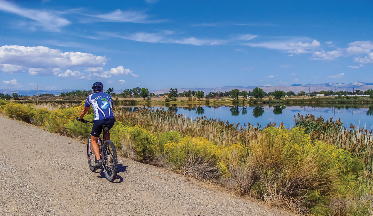
Image Courtesy of Emily and Mark Fagan
Fruita + Palisade
Dropping 95 miles south, we arrived at Fruita, Colorado, a mountain-biking mecca and the gateway to Colorado National Monument. We first took in the sights by bike, riding portions of the paved Colorado Riverfront Trail that goes between Loma, Fruita, Grand Junction, and beyond. For many, Colorado evokes images of craggy mountains and snow, so Fruita seemed an odd name for a Colorado town.
However, at the farmers market we discovered the name is perfectly apropos as we savored locally grown apples and melons that were bursting with flavor. We threw our heads back in laughter as sweet melon juice ran down our chins, and then spotted some adorable alpacas for sale in a pen next to us. The breeder told us these cute-faced animals are docile and are really fun to raise. We petted their soft fuzzy heads while listening to a live band playing folk music in the background.
This part of Colorado is great for growing grapes, too, and there are a surprising number of vintners making fine wines east of Grand Junction in the verdant farming areas around Palisade. We got a map for the Palisade Fruit and Wine Byway, which was a pretty drive, and we did a little wine tasting along the way.
Colorado National Monument
All of this wonderfully lush farmland is made possible by irrigation from the Colorado River that flows through these towns. However, south of the river there is a vast outcropping of red rocks and sandstone that stands in stark and arid contrast to the bountiful harvests happening in Fruita and Palisade. Colorado National Monument embraces much of these dramatic landscapes, and Scenic Rimrock Drive took us from one stunning viewpoint to another.
We strolled the easy 1.5-mile round-trip Canyon Rim and Window Rock trails, giving us a terrific view of 450-foot-tall Independence Monument jutting up out of the desert floor, followed by a glimpse through Window Rock at the green valley beyond. As we made our way across the wide and flat rock shelves underfoot, we kept hearing voices in the distance but couldn’t figure out where they were coming from. Suddenly we saw some people on the top of Independence Monument’s skinny spire. A group of rock climbers was fearlessly ascending the uppermost reaches of the pinnacle!
We later learned that the first person to scramble up Independence Monument was John Otto in the early 1900s. Today’s most popular route to the top is the one he took. His dream was to see the exotic landscape set aside as a national monument. Besides tirelessly campaigning for the creation of the Colorado National Monument, which was established in 1911, he also oversaw the construction of much of Scenic Rimrock Drive, which boasts 52 switchbacks in just 4 miles.
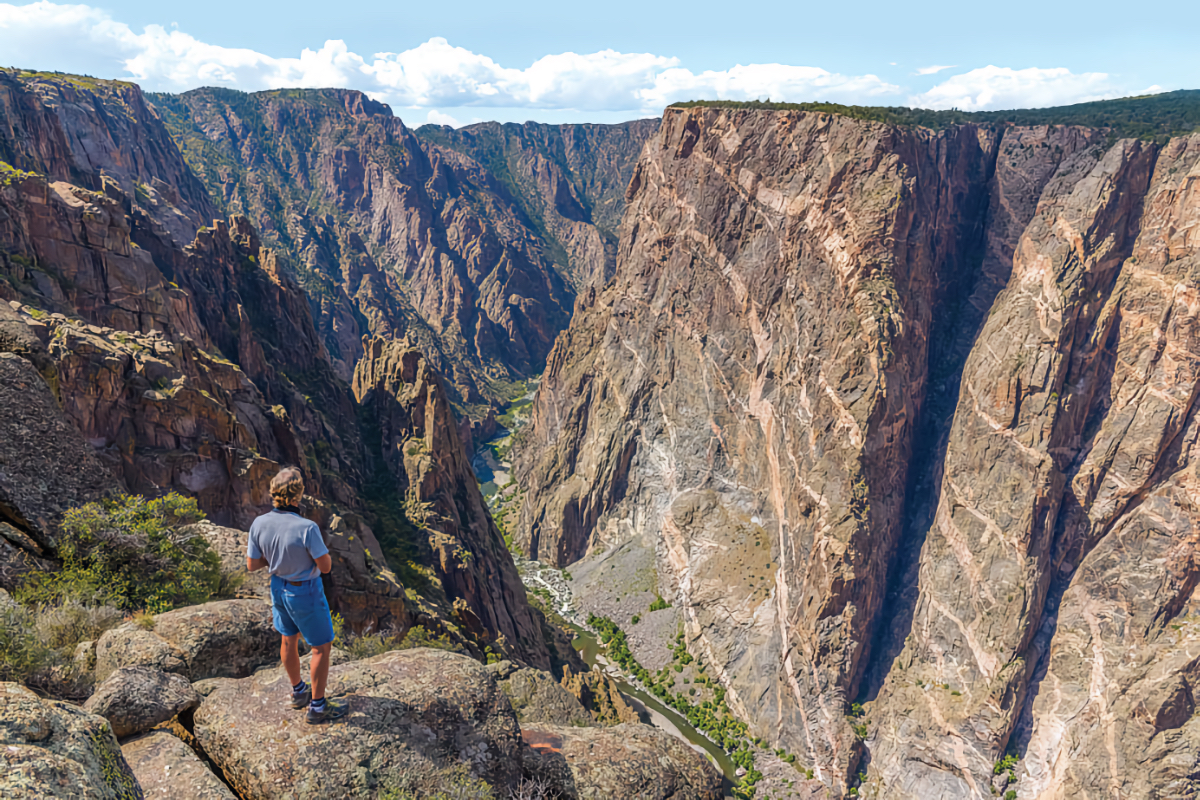
Image Courtesy of Emily and Mark Fagan
Black Canyon of the Gunnison
We found Black Canyon of the Gunnison National Park to be even more out of this world. Carved by the fast-flowing Gunnison River, which picks up speed by dropping 95 feet of elevation for every mile of distance, the water has cut through the black jagged volcanic rock like a knife. At its narrowest point, Black Canyon is just 1/4 mile across, and the depths of the sheer walls range from 1,750–2,700 feet. By comparison, the Empire State Building is only 1,454 feet tall.
Black Canyon of the Gunnison National Park lies south of the river, and a short road runs alongside the water’s edge at the bottom of the canyon. For the most breathtaking views, we went outside the national park and drove Colorado Route 92, which snakes along the crest of the canyon north of the river.
As we gazed down at the river far below, it was hard to imagine that beneath its surface the Denver and Rio Grande Railroad had once operated a narrow-gauge rail line in the late 1800s and early 1900s. Thousands of tourists took the Scenic Line of the World through 15 miles of the most impressive part of Black Canyon. The rail line was built by Irish and Italian immigrants in 1881–’82 and service ended in 1940. By the early 1960s the rail lines had been removed, the Blue Mesa Dam had been built, and the whole area had been flooded to form the long and narrow Morrison Reservoir.
Nearby, we explored the beautiful mountain scenery along Castle Creek Road where we came across Ashcroft Ghost Town. As interesting as the old, dilapidated buildings were, we were most intrigued by the Catto Center at Toklat next door. Inside we found many handsome wool rugs made by rug weavers from Teotitlán del Valle, a village outside Oaxaca, Mexico. A petite Mexican woman showed how the wool is dyed using insects and flowers to obtain the colors.
Our jaws dropped because we had recently visited that village during a tour of Mexico and we’d seen similar rugs and the exact same demonstration. The rugs were beautifully crafted and we were amazed a second time over that the indigo plant can create royal-blue wool, moss makes wool bright green, marigolds turn it yellow, and crushed bugs transform it into a vivid scarlet.
This colorful voyage through northwestern Colorado was a blast, and we highly recommend you take your time and relish it all!