The Red River is born near the neighboring towns of Wahpeton in North Dakota and Breckenridge in Minnesota. While still in its infancy, the Red has been given the political role as the boundary between these two states as it crawls on a meandering course of 394 river-miles to the Canadian border — a straight-line distance of 186 miles.
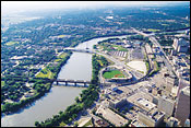
The Red continues to twist as if chasing a snake across the prairies of Southern Manitoba. After passing through downtown Winnipeg, it heads for Lake Winnipeg, where it empties. Its waters eventually flow into Hudson Bay at the north end of Manitoba, and off the maps familiar to most of us.
What’s surprising to me — it defies my sense of things, those laws of nature learned as a kid — is that the Red River flows north. For a short distance it parallels the Mississippi which, of course, flows south. The Mississippi’s headwaters are in Minnesota. They’re about 100 miles east of the Red and not far from Duluth, where I grew up. Childhood perceptions are the hardest to give up.
At the end of the last ice age — I take some solace in this — the Red River did flow south. But, when the glaciers receded, the Red changed direction, flowing north into the depression created by the departed glaciers.
In the States, it’s called the Red River of the North, to distinguish it from another Red River, a tributary of the Mississippi
that forms part of the border between Texas and Oklahoma.
The Red and the Mississippi are muddy-bottomed siblings of America’s Heartland, both rivers slow, murky and lazy. But both can flash into a rage of rushing water bringing devastating results in the towns and cities that normally bask in their serene, reflective beauty.
Before railways and highways were built, steam-powered paddle-wheelers plied both rivers. Today the Red is not used for commerce. And from what I saw of it, it’s not used much for recreational boating either. People do fish the Red and pull good-size catfish out of it, but I saw no marinas in Winnipeg.
I found public marinas and private docks at the river, however, including one at The Forks. The river is the focus for wide-ranging recreation around Winnipeg and the Red River Valley. “Routes on the Red” they call them — self-directed tours for walking, driving, paddling or cycling. “Walk in the footsteps of voyageurs, paddle the routes of the fur traders … more than 20 routes to choose from,” the brochures tell us. So I did some of it — at least a few days’ worth.
I quickly discovered why boating on the river is not popular. Look at a map of Manitoba. Count the lakes. They claim here there are 100,000 of them. Who wants to restrict their boating or waterskiing to the confines of a river, with all those beautiful lakes out there? Consequently, the river functions mostly as scenery, or a place on which to paddle a canoe or a kayak.
The Forks, where the Red is jointed by Assiniboine River, has retained its role through history as a place for congregating and remaking of the culture of the Canadian West. This piece of land, 56 acres and now part of downtown Winnipeg, was the main arena where the French and English battled each other for control of the trade with the Native trappers and hunters. (In Canada, Indians are quite simply called “Aboriginals” or “First Nations people” — we seem to prefer “Native Americans.”)
In 1888, the railroad built a terminal at The Forks, and rail activity came to dominate it. Winnipeg is a large transportation hub and the railroad still operates in its original terminal adjacent to The Forks — Union Station — designed by the same architects who built Grand Central Station in New York City. To this day, The Forks has remained a central meeting place. Tourists and locals alike collect here to browse the boutiques, stores and eateries in the old train shops.
I crossed the Red on the Esplanade Riel, also called the Saint Boniface pedestrian bridge. Its superstructure is a fan of cables, spreading from a transversely inclined pylon that towers high above the center of the bridge. A restaurant at the base of the pylon is literally hanging over the edge, suspended by another fan of cables. Painted a brilliant white, the bridge is a standout addition to the city’s skyline, especially at night when it is flooded with light.
Stepping off the bridge, I was in Winnipeg’s French quarter. Known as Saint Boniface, it’s the cultural center of the West for French-Canadians. Now simply a neighborhood — albeit with its own culture, food and language — it was a town for almost a century. It became part of Winnipeg in 1972.
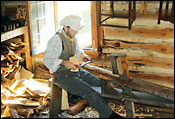
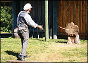
Fort Gibraltar is a replica of an old trading post. There I met Robert Frechette, 25, who was playing a solo game of “darts,” vintage 1815. With three hatchets in one hand, he was throwing them, one at a time, with the other. His target was the butt of a log propped up on its side.
“Actually, they called it what it is: hatchet throwing. But it was played like darts,” he said. Robert is a carpenter. “Most of us who live in St. Boniface can trace our ancestors back to the French fur traders. Many came as voyageurs who guided and paddled the canoes of the explorers.”
Voyageurs also transported the furs across the continent. They worked 14-hour days, were expected to paddle 50 strokes a minute and portage 90-pound loads. Many settled here, becoming craftsmen.
“When I’m here at the fort,” Robert said, “I work with the tools my ancestors used. I am making some chair legs in the whittling house with a straw knife. It takes a while by our view of time. But it’s the only tool they had.”
Welcome to America’s Outback.
Bill’s e-mail address: [email protected]

