Driving the Blue Ridge Parkway for Fall Colors
Image Caption:
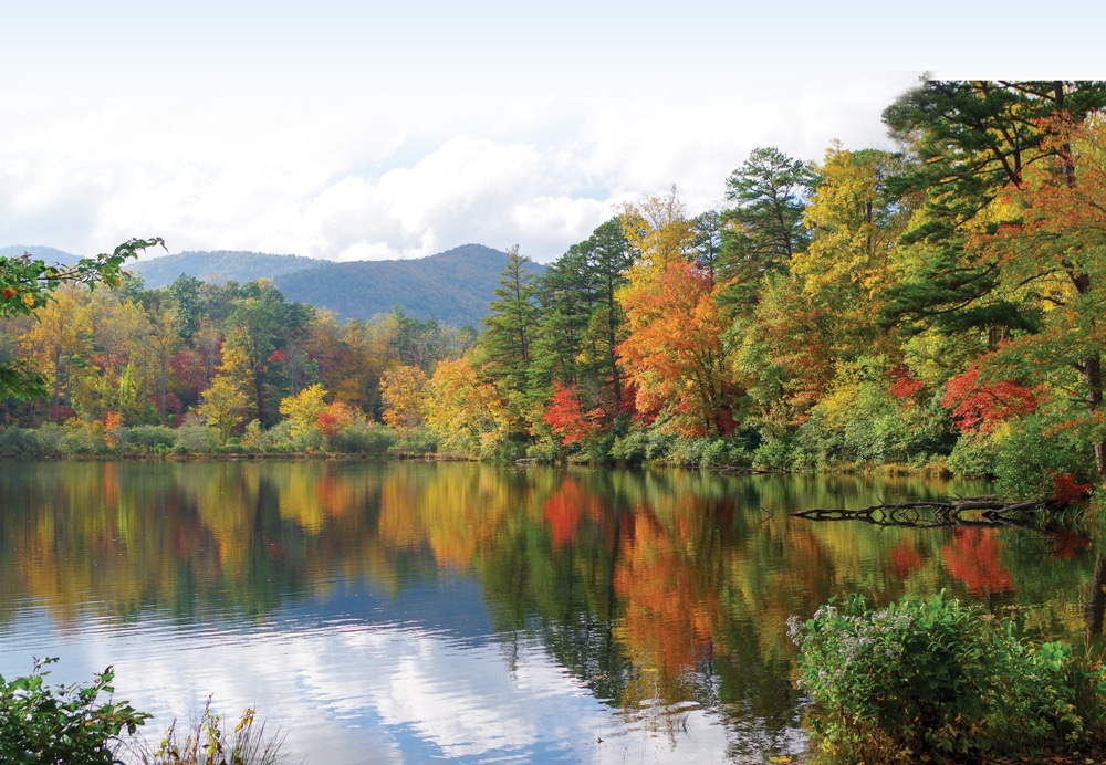
In addition to the scenic autumn splendor, the Lake Powhatan Recreation Area offers a swimming beach, trout fishing, cascading waterfalls, and hiking and mountain-biking trails.
As we drove our motorhome along the Blue Ridge Parkway, we couldn’t stop oohing and aahing at the magnificent views at every new turn in the road. Traveling from the north, we had timed our trip to arrive in Asheville, North Carolina, in mid-October, when the autumn leaves were in all their glory. We took a couple of days to check out Asheville – its terrific farmers market, the town’s eclectic shops and some of the local brewpubs – and camped nearby at Lake Powhatan Campground (828-670-5627), a U.S. Forest Service facility with available electric hookups and showers. From the campground, we hiked a short 1-mile trail to the North Carolina Arboretum (www.ncarboretum.org), 65 acres of cultivated beauty. This was all good fun, but we were just warming up for our time in the Great Smoky Mountains.
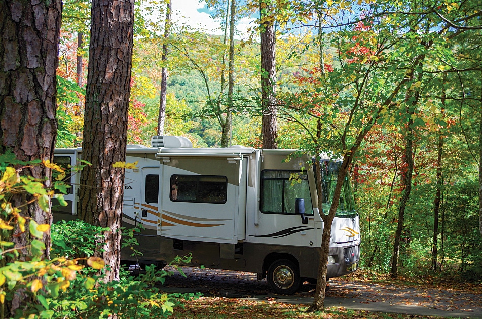
Lake Powhatan Campground offers nearly 100 sites (20 with full hookups) and an RV dump station. Most sites are private and shaded, and all have picnic tables, tent pads and fire rings. Hot showers and flush toilets are available in the bathhouses.
Great Smokey Mountains National Park
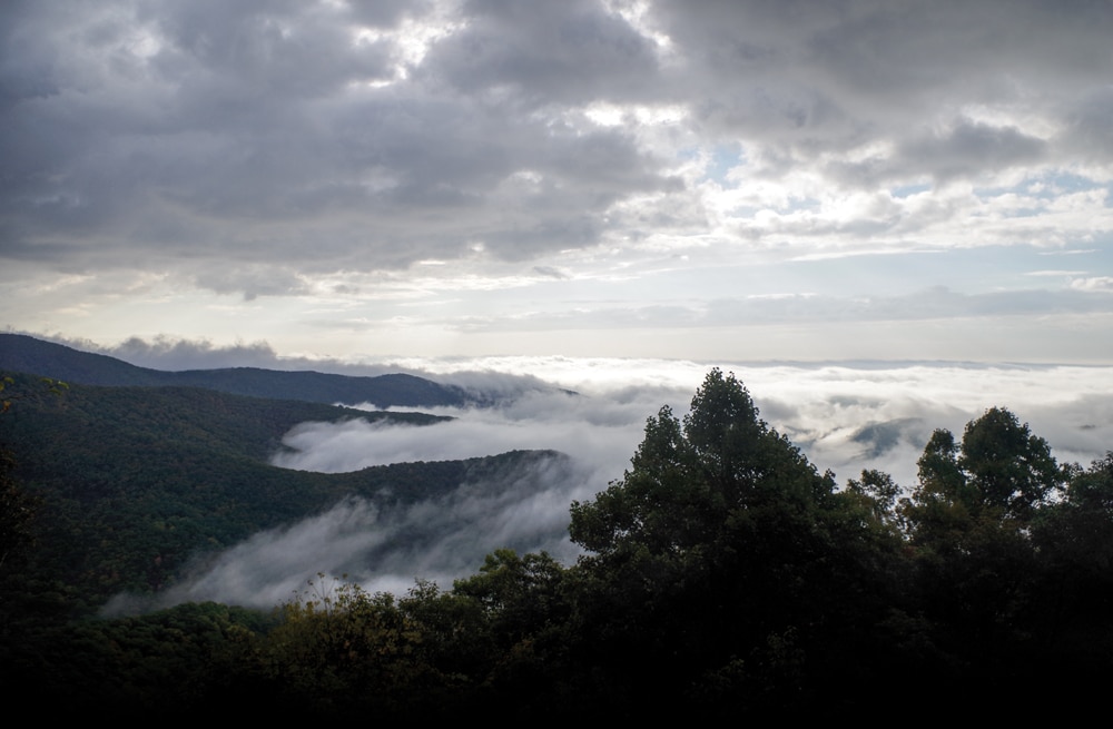
We awoke to a misty morning, the perfect day to head to Great Smoky Mountains National Park. First, we needed to decide whether to continue along the Blue Ridge Parkway to the park entrance, or to take an alternate route due to the mist and fog. This stretch of the Blue Ridge has the highest elevation, with some great views, and we didn’t want to miss these. So we delayed awhile, waiting for the fog to clear, and decided to take the Blue Ridge option. We’re glad we did; the fog lifted as we climbed through the 6,000-foot mountain pass. Along the way, we stopped at mile marker 422.4 and took the hike at Devil’s Courthouse up to a promontory. This is a fairly steep hike, but worth the effort, as we watched the sun break over the mountains. Knowing that there are some tunnels in the last 5 miles of the Parkway that are not RV-friendly, we exited by Soco Gap (mile marker 455.7) and headed to the town of Cherokee on U.S. Route 19.
Water and hydrocarbons emitted by the dense forest give the Great Smokies their name.
Cherokee was a good place to fuel up, fill our pantry and then take a couple of hours to visit the Museum of the Cherokee Indian. There are lots of exhibits and history at the museum on the first 10,000 years of this Indian nation. The museum depicts the arrival of the British and their trading, the settlements of the new Americans encroaching on Cherokee territory and then their forced relocation to Oklahoma. One Cherokee clan was able to return and purchase land, and has now become re-established in their former tribal lands.
Following our history stop, it was time to enter Great Smoky Mountains National Park, with an immediate stop at the Oconaluftee Visitor Center. We learned that this park is the most-visited national park in the country, with more than 10 million visitors annually. We picked up the fall park newspaper, park maps and a good book on local hikes. Loaded with all of this information, we started driving the Newfound Gap Road. We had been a little bit concerned about driving our motorhome on this road (U.S. Route 441), but it turned out not to be an issue. The road climbs to the Newfound Gap, with an elevation of 5,046 feet, and then drops back down toward Gatlinburg, Tennessee, following the Little Pigeon River. The road is well-paved, with wide shoulders and fairly gradual grades as well as many pullouts with mountain views. We thoroughly enjoyed the sights and watched the many different forests change as we climbed up and down from the gap.
After 33 miles on this pleasant drive, we reached the Sugarlands Visitor Center, where we turned west onto Little River Road (and then Laurel Creek Road) for another 18 miles. A beautiful but fairly tedious drive in our 30-foot motorhome, we reached our first campground destination in the Smokies, located in Cades Cove.
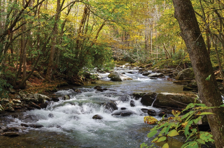
Serene sights such as this stream on Little River Trail are common.
Cades Cove Campground
Cades Cove Campground is a pretty typical national park campground. The primitive sites are fairly close together; no hookups are available, but there are flush toilets, drinking water and a dump station. There is an adjacent camp store with basic necessities (including ice cream!) and bike rentals. The best part about this campground is its location close to the Cades Cove Loop Road and the many hiking trails. With 159 campsites for RVs up to 35 feet, this campground does fill up on weekends, as it did while we were there. The peak fall colors brought out many of the campers.
Fortunately, we had made reservations (877-444-6777), so we had no issue getting a campsite. We recommend you do the same. While staying at this campground, we spotted white-tailed deer and heard rumors of nearby sightings of black bears, coyotes and turkeys.
Cades Cove Loop Road
The main event is the 11-mile Cades Cove Loop Road, which begins only a quarter-mile from the campground. The valley of Cades Cove held a vibrant community in the late 19th century. Throughout the valley there are still many buildings from this era, including log homes, barns, a gristmill and three churches. Many of these buildings have been restored and are open to explore. You can make the drive with your dinghy or, as we did, bicycle the length of the loop.
Having brought our bikes with us, we set them up, loaded a picnic lunch and some snacks in our panniers and off we rode. Because it was a Saturday morning, we ran into some heavy car traffic driving the same one-way loop, and since we were into late October there were no bicycle-only times. (Every Wednesday and Saturday morning prior to 10 a.m., the road is closed to automobile traffic, from the beginning of May until the third week in September). Fortunately, after the first mile, the traffic congestion cleared and we could enjoy the ride. We stopped at many of the cabins and churches, and took a longer break by the Cable Mill to enjoy our lunch. There is also a small general store with souvenirs and snacks.
We spotted a park ranger interpretive talk and went over to hear a discussion about bear safety. A volunteering 12-year-old boy with a bearskin was demonstrating the proper actions to take when confronting a bear. With more than 1,500 bears in the park, this was good information. Next we talked with a park ranger who was playing a psaltery, a musical instrument from the era. Played with a bow rather than plucked, it was hauntingly beautiful. The ranger said it was a combination of the Irish-Celtic and the German settlers’ instruments. Following our break, we got back on our bikes and continued the loop with stops along the way. Arriving back at the campground, with the blue skies of fall, and the leaves coming down, we sat by our campfire and relaxed, planning for our next two days of hikes.
Anthony Creek Trail
And hike we did. Waking up in the morning with the mists surrounding the mountains, we ate a hearty breakfast and then assembled our packs and headed out on the trails. It’s really good to have so many trails leaving right from Cades Cove Campground. Today’s hike was the Anthony Creek Trail, only a little over a half-mile to the trailhead, and then we continued another couple of miles to where we met up with the Appalachian Trail. We enjoyed the great views of the leaf colors and the surrounding mountains.
The following day, we hiked the 5-mile round trip to Abrams Falls. Even though these falls are only 20 feet high, the volume of water crashing down the rocks into a long, deep pool made this one of our favorite waterfalls in the park. The pine and oak forest along the ridges, the hemlock and rhododendron forest along the creek and another sunny blue sky all made for another perfect fall day.
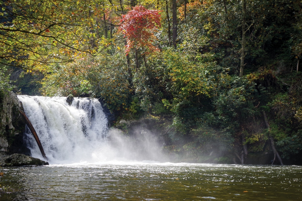
A moderate 5-mile round trip hike through pine-oak, hemlock and rhododendron forests rewards visitors with 20-foot-tall Abrams Falls, named for a Cherokee chief who lived down-stream.
Elkmont Campground
We could have lingered at Cades Cove Campground for many more days, but we decided to head to Elkmont Campground and check out another part of this park. Once again, we were glad we had made reservations, since the campground was full. The fabulous weather and peak fall colors had much to do with the lack of available sites. The 220 campsites at Elkmont are more spacious than Cades Cove. There is a maximum motorhome length of 35 feet here (32 feet for trailers). Elkmont is also centrally located to a number of hiking trails, the nearby Sugarlands Visitor Center (where the RV dump station is located) and the 1.9-mile pedestrian bike/walk trail from the visitor center to Gatlinburg. There is also a shuttle service from the campground to Laurel Falls and to Gatlinburg.
We skipped the walk into Gatlinburg, although driving through the main street on our way out of the park, it did look like fun checking out the local souvenir shops, the many restaurants and the constant activities at the convention center. We did decide to take the Cucumber Gap Trail (with a name like this, how could you not?). This was another lovely hike through the woods, and then a surprise. In the early 1900s the Appalachian Club was established by visitors from Knoxville. They built a large clubhouse for their social activities, and many cabins to house the visitors. This was quite a happening place in its day. The National Park Service has restored the clubhouse and is working to restore many of the other buildings. Our hike led us down the main street of this development. At one time, the location of the Elkmont Campground was part of this resort, but we had no idea we would come across this village at the back of our campground.
After a few days, it was time for us to move on, but there were so many more hikes and waterfalls that we wanted to see. We will just have to make another trip back here in the future. We thought we had picked the perfect time to see the Great Smoky Mountains with its vibrant fall colors. Or did we? When the rhododendrons bloom in May, the spring flowers pop; is that a better time to visit? Or is it the summer, when the mists have cleared? There’s so much to do and see here in Great Smoky Mountains National Park. It’s easy to see why this is the most-visited national park.
For More Information
Blue Ridge Parkway | 828-298-0398 | www.nps.gov/blri
Great Smoky Mountains National Park | 865-436-1200 | www.nps.gov/grsm
Museum of the Cherokee Indian | 828-497-3481 | www.cherokeemuseum.org