
New Mexico’s Chaco Culture National Historical Park is rugged AND REMOTE, with clear, dark skies perfect for night-sky viewing
What if you could drive your motor-home right into the center of a place as highly regarded as the Acropolis in Greece,  England’s Stonehenge or the Egyptian Pyramids, and stay the night alongside ancient stone dwellings? We did exactly that while touring northern New Mexico in our 22-foot Class B motorhome last September.
Sound far-fetched? Not at Chaco Culture National Historical Park, a site designated in 1987 to the prestigious World Heritage List of “places with outstanding universal value” created by UNESCO, the United Nations Educational, Scientific and Cultural Organization.

At Chaco’s observatory, star gazers can attend Night Sky programs several nights a week from April through October. Photo: National Park Service
What’s so exciting about this remote, high-desert canyon? The monumental remains of a culture that flourished in the Four Corners region from A.D. 850 to 1250, “the largest, best-preserved and most complex prehistoric architectural structures in North America,” according to the National Park Service (NPS).
Inside Chaco Canyon are massive “great houses” built by ancestral Puebloan stonemasons more than 1,000 years ago. Chacoans carved stone stairways into and out of the canyon, and engineered some 400 miles of 30-foot-wide, prehistoric roads connecting to more than 150 “outlier” great houses. And without benefit of wheels or pack animals, they carried approximately 225,000 tree trunks from distant mountains back to Chaco for use as wooden beams.
Why did these people choose to build elaborate projects in such a place with long, cold winters, hot summers and meager rainfall? Did they purposely align the buildings to mark solar and lunar movements? And why did they abandon their valley, after using it as a hub of ceremony and trade for more than 300 years? Some researchers think drought or famine were factors, while others believe political or religious conflicts caused Puebloan people to migrate away during the 13th century.
Such mysteries continue to burnish Chaco’s mystique for travelers. But there’s no mystery about why so few people come here; it’s the park’s isolation and notorious access roads.
Would-be visitors discover they must drive on miles of dirt road to reach Chaco. There is no public transportation, and
the closest lodgings are more than 60 miles away in Bloomfield, New Mexico. There are no fuel stations, restaurants or grocery stores in or near the park. At 6,200 feet, Chaco is a high-desert environment where temperatures can swing 50 degrees in a day.
So arriving in a motorhome with plenty of food, water, fuel, beds, furnace and an all-temperature wardrobe is an enviable solution. (The maximum RV size in the park’s campground is 35 feet, and dispersed camping is not permitted.)
How to get there? The NPS recommends that RVs avoid entering Chaco from the south via Route 9, an approach that involves either 20 or 33 miles on rough to impassable dirt roads complicated by missing signs and inaccurate GPS information.
There’s a more viable option: Turn off U.S. Highway 550 at County Road 7900 (located 3 miles southeast of Nageezi, New Mexico, or about 50 miles west of Cuba, New Mexico, at mile 112.5). This 21-mile route is well marked and includes 8 miles of paved road (County Road 7900) and “only” 13 miles of washboard dirt road (County Road 7950).
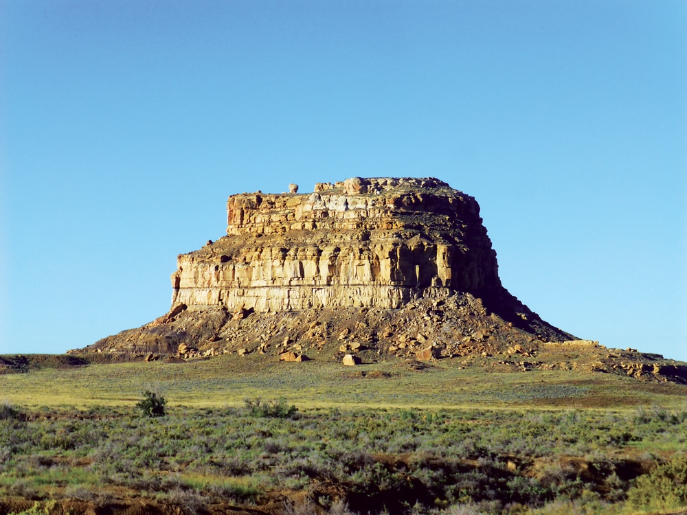
Atop Fajada Butte, a spiral petroglyph known as the “Sun Dagger Site” marked the equinoxes and the solstices.
Plan to drive during daylight hours and don’t count on a cell signal. Avoid side ditches, watch out for farm animals and heed a sign posted near a stream bed: “Danger! Do not cross if wash is flowing.” The road can be a jarring washboard of ruts, depending on when it was last scraped, so be alert especially during the last 5 miles before entering the park.
The NPS staff at Chaco suggest that drivers call to inquire about current road conditions before setting out (505-786-7014). Take them up on the offer, and pay attention to the weather forecast if you plan to arrive during the Southwest’s monsoon season of July, August and September. Driving will be more feasible when the road is dry.
“We’ve had people getting through today,” advised a cheerful ranger at the other end of our phone call last September after a few wet days. “Stay in the ruts and you’ll be all right.” Rain that morning had turned 7950 to mud as slippery as ice. We took it slow, arrived an hour after leaving Highway 550 and selected a campsite.
Near the park entrance, the simple Gallo Campground at the base of a cliff was our first taste of the “Chaco Phenomenon.” We walked a petroglyph trail, built a campfire, fell asleep by a stone alcove dwelling (circa A.D. 1150) and awakened to bright sunshine painting Fajada Butte with gold.
Gallo Campground has 49 dry camping sites, each with a picnic table and fire grate. Facilities include a dump station and flush toilets but no showers. Drinking water is available in the visitor center parking lot. Site fee is $15 a night.
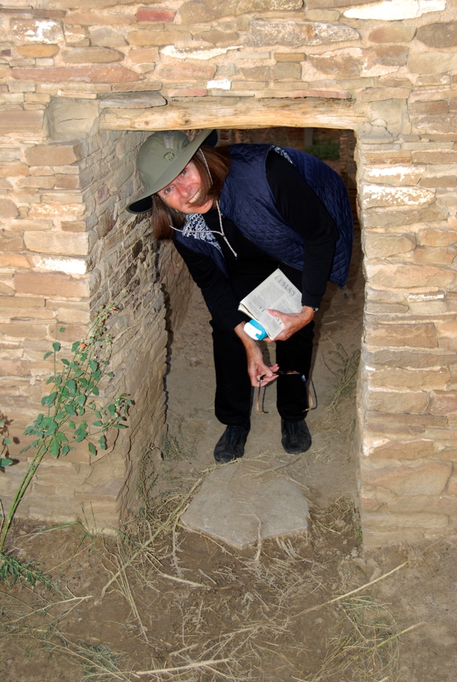
Visitors must bend over to pass through Pueblo Bonito doorways, which may have been kept small for heat retention or defensive purposes.
Atop the butte, a sacred place for Pueblo, Hopi and Navajo people, is the Sun Dagger site, evidence that Chacoans were ancient astronomers who tracked the sun’s movements. Until 1989, when three stone slabs shifted slightly, sunlight that passed between them fell onto a spiral petroglyph and marked the equinoxes and the summer and winter solstices.
A mile from the campground is the recently rebuilt visitor center and bookstore where campers can pay for site and entrance fees, watch an introductory film and study a useful canyon wall map. Park rangers lead free, guided walks of the largest site, Pueblo Bonito, year-round, as well as other walks and programs from April through October.
The next morning, we drove past a small herd of elk that live in the park, and continued on the 9-mile, paved Canyon Loop Drive that led to six major places we could easily explore. (There are more than 3,000 historic sites in the park but not all are excavated or accessible.) We parked and walked along well-marked, self-guided trails using free loaner guide pamphlets.
After having visited other National Park sites that were packed with hoards of people, we could hardly believe our good luck in picking a crisp, sunny day when we had this place almost entirely to ourselves. Later, we learned that fewer than 30,000 visitors came to Chaco Culture National Historical Park in all of 2013, an average of only about 82 per day.
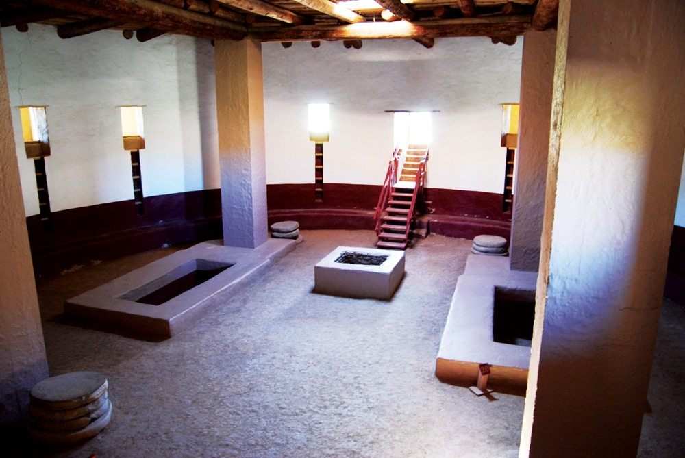
In the solitary silence of the canyon’s heart, we tried to imagine people using the D-shaped Pueblo Bonito great house 1,000 years ago, adding onto it over three centuries until it covered 3 acres, rose to four or five stories and had more than 600 rooms.
We bent over to fit through doorways into the rooms, and walked across two open plazas, where researchers believe that community gatherings and trading once took place. Evidence of trade goods, such as pottery, turquoise, seashells, scarlet macaws, copper bells and cacao (chocolate) from as far away as Mexico, have turned up during excavations.
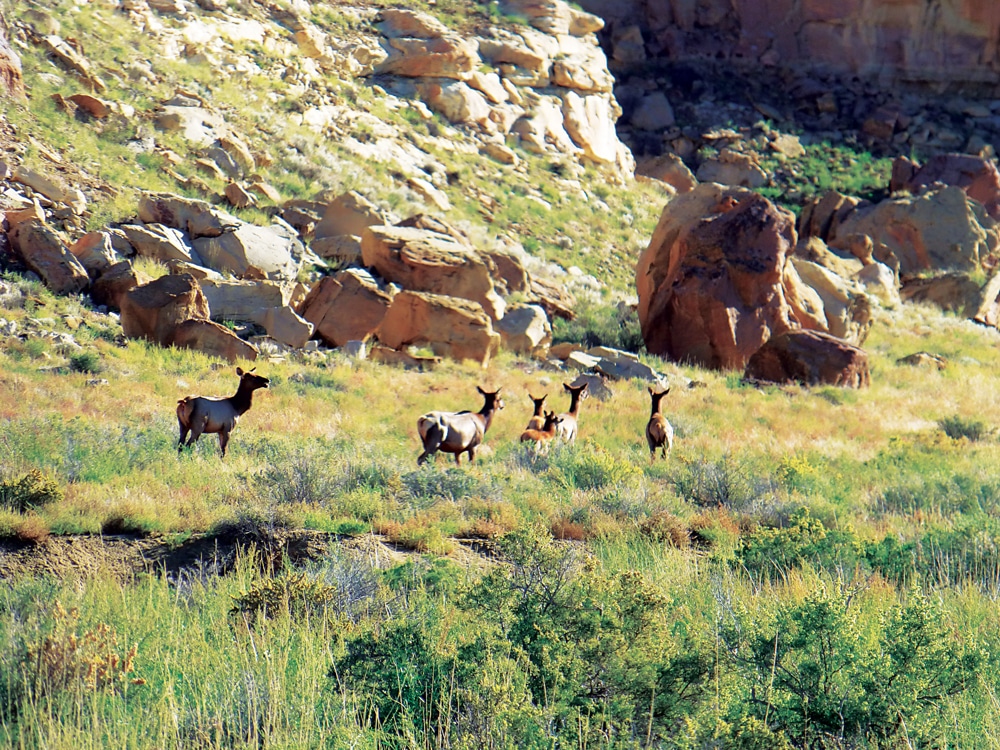
Chaco Culture National Historical Park is the high-desert home to some 60 elk.
We looked for ancient symbols and characters on the Petroglyph Trail near Pueblo Bonito’s cliff. According to the trail guide, “Chaco is the only known place in the world where the techniques of pecking, incising, abrading and drilling were all combined in a single image,” that of a bird. We spotted stick figures, animals and sun-like spirals, the canyon’s most common image.
Our next stop was the canyon’s second-largest building, Chetro Ketl, with a plaza elevated 12 feet above the valley floor. We peered into one of the largest of Chaco’s many great kivas, round sunken chambers used for worship or other ceremonies.
We walked through the Pueblo Del Arroyo’s D-shaped great house remnants, with flooring made of beams, sticks and mud, and continued on to a simple, wood-fenced graveyard. We were surprised to learn that explorer Richard Wetherill, who came to Chaco from Mesa Verde in 1896, was buried here with his wife. He excavated and homesteaded around Pueblo Bonito, operating a trading post until he was shot in 1910 by a Navajo neighbor.
From one canyon great house to the next, we admired stonework that often varied within the same structure. Skilled masons quarried rectangular blocks from the sandstone cliffs, fit them together closely with mud mortar and sometimes chinked them with small mosaic-like pieces. Finally, they covered the walls in plaster, which no longer remains. On a ranger-led hike from the visitor center, we walked up to the largely unexcavated Una Vida and learned that the rubble core and thin veneer masonry styles in the canyon changed over time, which has helped archaeologists estimate construction periods.
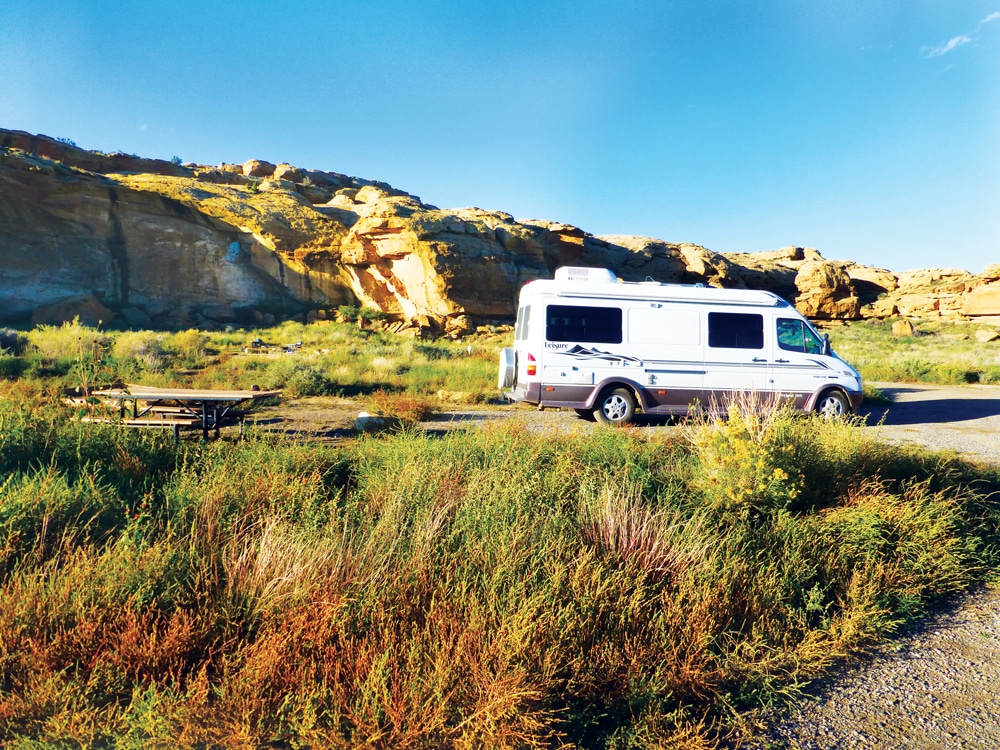
Gallo Campground can accommodate RVs up to 35 feet long.
After visiting for just a day and two nights, we agreed with UNESCO: Chaco’s ancient urban ceremonial center “is unlike anything constructed before or since.” Next time, we’ll hike beyond the paved roads farther into the canyon and climb to the Pueblo Alto complex for sweeping views from atop the cliffs.
Though Chaco seems timeless, there have been recent changes worth noting. The NPS announced a reservation system that began in January. “We will be using the www.recreation.gov website for the Gallo Campground reservations,” reported Christine Czazasty, the park’s chief of interpretation. Previously, a first-come, first-served system meant some campers had to turn around during busy times.
In August 2013, the International Dark-Sky Association certified Chaco Culture as an International Dark-Sky Park, only the fourth unit of the NPS to receive that designation. At Chaco’s observatory next to the visitor center, stargazers can attend night-sky programs several nights a week from April through October, a bonus missed by day-trippers.
And as for County Road 7950? It’s not likely to change. Late in 2012, after more than a dozen years of meetings and studies, San Juan County Commissioners gave up on a plan to pave the road due in part to opposition from environmental and Native American groups.
But that’s OK. Making it into Chaco Canyon just adds to the campground camaraderie, and other RV travelers we talked to during our visit agreed.
Reaching what the Hopi call “the place beyond the horizon” was worth the journey.
CHACO ALTERNATIVES
Easily accessed Aztec Ruins National Monument’s reconstructed great kiva helps visitors visualize how these structures may have looked inside.
If you’d rather not take your motorhome into Chaco, consider driving your dinghy vehicle in or renting a car for a day. If you’re short on time, visit smaller, more easily reached northern New Mexico sites that archaeologists believe were part of the “Chaco World.”
Aztec Ruins National Monument, 75 miles north in Aztec, New Mexico, became a World Heritage Site as part of Chaco Culture. It has Chaco-style masonry, large rooms and a reconstructed great kiva that visitors can enter to visualize how these structures may have looked in ancient times.
South of Aztec, between Bloomfield and Farmington, New Mexico, the Salmon Ruins site owned by San Juan County has a Chaco-style tower kiva, similar to one at Chetro Ketl and a plaza with a great kiva.
 Christine Goodier is a freelance writer and editor who lives on the North Carolina coast and travels with her husband, photographer Bob Goodier, in a Class B Sprinter motorhome.