
From royal-blue Crater Lake to the outdoorsy yet cosmopolitan city of Bend, this high-desert playground is flanked by the captivating Three Sisters peaks and perennially unattached Mount Bachelor
Central Oregon is protected from the Pacific Ocean’s wet storms and moist air by the towering Cascade mountain range, giving it a dry climate that locals call the high desert. An RV trip through this area quickly makes it apparent, however, that it  is hardly an arid place. Many beautiful rivers and stunning lakes fill the region. The sound of rushing streams and the sight of calm water set against snowcapped mountain backdrops become familiar and almost commonplace after camping in the area for a while.
On a recent trip with our fifth-wheel trailer, we came into central Oregon from the south after crossing the hundreds of miles of vast, open and barely inhabited desert valleys that spread out across southeastern Oregon and northern Nevada. What a feast for the eyes it was to arrive at sparkling Diamond Lake, where the last vestiges of winter snow blanketed Mount Bailey, deep green trees pressed against a bright-blue sky and tiny wind-whipped waves lapped the shore. A paved 13-mile path around the lake made for an easy bicycle ride and gave us views of the water and surrounding mountains from all sides.
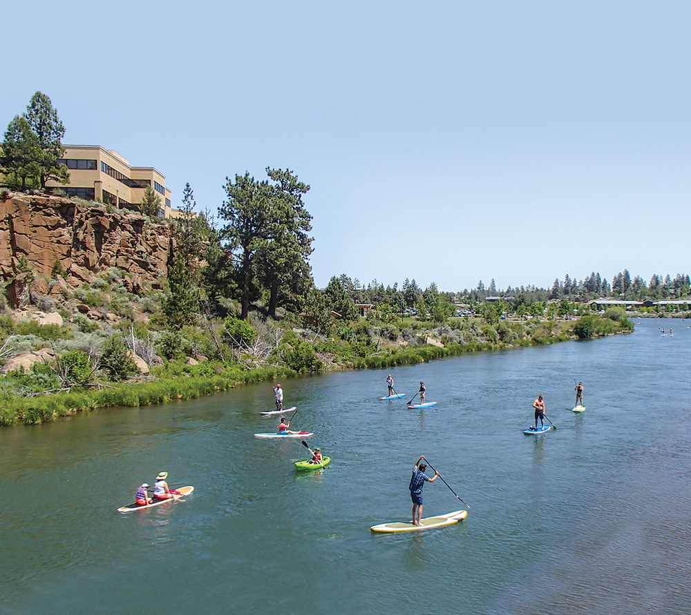
Outdoor enthusiasts paddle and float along the Deschutes River in Bend.
However, pretty Diamond Lake paled in comparison to her spectacular big sister, Crater Lake, a few miles away. We visited the national park on a warm morning in late May and were shocked to find snowdrifts that were twice our height in size. Even more stunning was the rich royal-blue color of the lake. As I looked at the dozens of photos I was taking on my camera, I had to keep double-checking the color of the water. Was it really that blue? Yes, it was! All around the lake, the snow-covered mountains swept down to the water’s edge, kissing their reflections in the placid water at the shoreline and creating perfectly mirrored images.
Crater Lake isn’t just for gawking. Hiking trails cut through the mountains that surround the lake, and in summertime the park service offers boat rides. We were there a little early in the season, before the snow had melted off the trails and too soon to get out on a boat to admire the scenery rising up from the shore. An equally enjoyable alternative was having a nice cold microbrew beer out on the deck of the old log-built Crater Lake Lodge overlooking the majestic scenery.
Oregon is known for its microbrews, and nowhere is that more evident than in the city of Bend at the hub of central Oregon. Just two hours north of Crater Lake, Bend is a youthful, hip and vibrant city with an outdoorsy, energetic spirit seemingly fueled by good coffee and great beer. There is a cute coffee kiosk or microwbrew pub on almost every corner, and in the dry air of this high-desert region, everyone makes it a point to keep hydrated!
The Deschutes Brewery offers free tours and tastings, and we got a kick out of sampling their tasty Mirror Pond and Red Chair ales. Bend is proud to have more breweries per capita than any other city in Oregon. To help visitors find all the breweries, the local visitor center has created the Bend Ale Trail, complete with “passports” that visitors get stamped at each brewery they visit. Collect 10 stamps, and the passport can be redeemed for a prize at the visitor center. We started filling in our passport stamps with great intentions but still have a few to go.
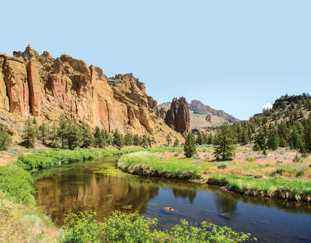
The Crooked River winds through Smith Rock State Park near Bend, Oregon.
The lovely Deschutes River flows through the heart of Bend, and following its flow is a great way to explore the city. The Deschutes River Trail runs along both sides of the river, through downtown and then further south for miles out into the countryside. The path is paved in town where it is part of the Urban Trail. In the center of the city, it passes the expansive grassy lawns of parks where dog owners toss balls for their dogs and kids play Frisbee. Following this path on our bikes, we passed a series of eateries at the Old Mill District, a goldmine for shoppers, where outdoor seating provides a great view of the river and mountains beyond.
What a surprise it was to stop at a bridge and see dozens of people out on the river on paddleboards, kayaks, floating tubes and even Coleman air mattresses, making their way up- and downstream and getting a tan. The pavement eventually yielded to a well-trodden dirt path that rose high above the river, and we could see some rapids at the base of the cliffs below. We watched a few intrepid hikers venture out onto some boulders midstream. The image of them sitting peacefully amid the rushing water, shirts off and swimming towels laid out on the rocks, a backdrop of sheer cliffs rising behind them with a sleek glass-walled office building perched at the top, seemed to describe Bend to perfection: rugged and adventurous yet chic and urban at the same time.
The Deschutes River Trail extends for many miles south of the city, and whether traveled by bike or on foot, the route is among the most scenic in the area. Passing black, jagged beds of lava rock, the trail soars up and down over hills that line the river, offering dramatic views of several waterfalls along the way. When the river flattens out into a less tumultuous flow, the trail wanders into wide meadows. It has many access points, but, even though the trail is shared by bikers and walkers, so few people are on it at any point that there is little congestion.
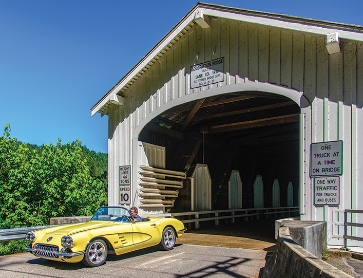
At 165 feet, the Goodpasture Bridge in Vida is the longest covered bridge still in daily use in Oregon.
Central Oregon is a woven tapestry of streams and rivers. Just a little to the north and east of Bend, the Crooked River winds an incredibly twisted path through the landscape. Smith Rock State Park is just a half hour north of Bend, yet when we came upon deer as we hiked its River Trail, it seemed a world away. Smith Rock is a rock-climbing mecca, and serious climbers scale its walls. I kept hearing voices and couldn’t figure out where they were coming from until I finally tipped my head back and looked up. Climbers were scattered across the rock face hundreds of feet above me!
Hikers can opt for a several-hour jaunt up and over steep hills past stony spires on the aptly named Misery Trail, or they can take a flat route on the River Trail along the banks of the river. Both trails are equally breathtaking for their scenic vistas, but the River Trail won’t leave you gasping for air.
The Crooked River extends far beyond Smith Rock State Park, and the scenic drive that follows it to the south and east is filled with generous views of beautiful farmlands backed by hills.
The small town of Prineville sits on this river’s edge about an hour east of Bend, and for 20 miles south of town, the river meanders through a canyon of fantastic lava beds and rock postpiles. The Bureau of Land Management oversees this entire section of the river and has created the Lower Crooked Wild and Scenic River Recreation Site, a heavenly spot for anglers (especially fly-fishing enthusiasts) where one riverfront campground practically blends into the next. At least half the sites are on the water, and they fill up quickly in the summer. These campgrounds are ideal for smaller to medium-size RVs, but the biggest rigs will require a shoehorn to get in.

The waterfront Deschutes River Trail entices both hikers and cyclists.
The McKenzie River flows on the west side of Bend, and it is perhaps best loved for the gorgeous scenic drive that follows its shores. Starting just outside the charming town of Sisters, the McKenzie River portion of the McKenzie Pass-Santiam Pass Scenic Byway climbs through a 10-mile series of switchbacks on the way to the summit. We climbed up the rocky stairs of the old stone Dee Wright Observatory turret at the top to take in the exotic views of vast lava beds that stretch to the horizon in all directions.
Also known as the McKenzie Pass Scenic Bikeway, this stretch is closed during the winter and for the first four weeks of spring is open only to bicycles, prior to opening to motorized traffic. A serious and scenic workout, the route is considered one of the premier road rides in the state. After taking a breather at the top, the most hardy cyclists fly down the sweeping hairpin turns on the far side of the pass before climbing up and over again to return to Sisters. Mountain bikers can catch a shuttle ride in Bend that will deliver them to the top of McKenzie Pass and pick them up after they soar to the bottom on a single-track trail through the thickly forested western flank of the mountain.
The other half of the byway is a little easier driving and travels over equally scenic Santiam Pass, which is open all winter. This route passes Suttle Lake, a small lake that is great for sailing and powerboating. The elegant Lodge at Suttle Lake (opening for the season on May 16 this year) is worthy of a visit. At the entrance a massive pair of handsome and elaborate wooden doors carved by Sisters artist Chester “Skip” Armstrong depict an Indian eagle dancer in a striking pose. Inside, a large and inviting stone-hearth fireplace awaits.
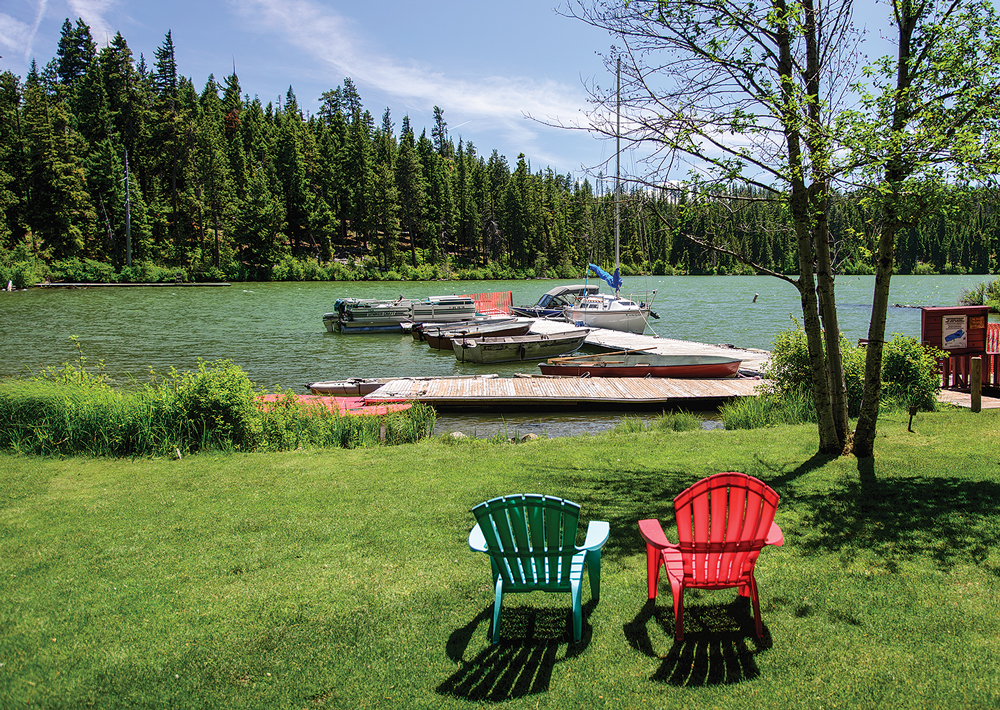
Pretty Suttle Lake makes a scenic stop on the drive over Santiam Pass in central Oregon’s Cascade Mountains.
Continuing along the McKenzie River, Sahalie (Chinook for “heaven”) Falls is among the most beautiful waterfalls in the state and can be seen after a short walk from the parking area. The blast of cold, moist air from the crashing falls was refreshing, and the stone stairs leading to its base lured us further down. From there, we discovered a junglelike walk that follows a pretty trail through the rainforest on the McKenzie River’s edge. Every now and then, the water rushing past us flashed a vivid turquoise. We were smitten by these falls and found the wet environment a fabulous contrast to the drier and dustier hikes along the Deschutes and Crooked rivers. Even the wooden handrails along the stairways were green with moss and damp and thick with forest growth.
Making our way a little farther along the McKenzie River, we came to the Goodpasture Bridge in Vida, the second longest covered bridge in Oregon and the longest that has been in continual use since it was built. We had thought that covered bridges were found only in the Midwest, but this bridge is one of several scattered throughout Oregon. As we stood there photographing this unique bridge, a mint condition 1959 Corvette convertible drove through it!
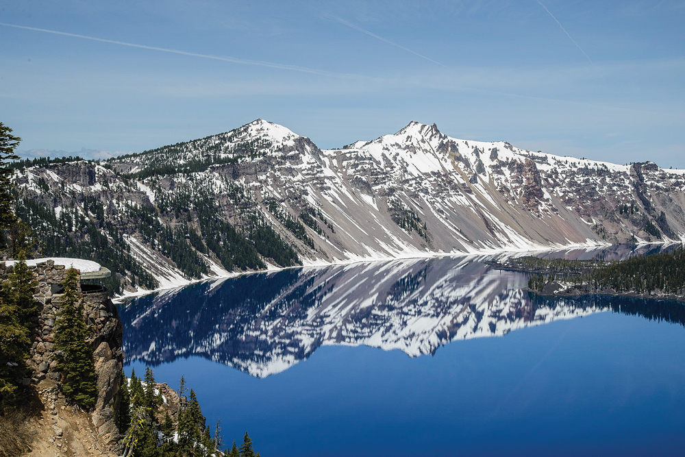
Vivid blue Crater Lake mirrors the rim’s sparkling snow and pine trees.
Another designated scenic route in central Oregon is the Cascade Lakes Scenic Byway. This stretch extends from Bend to the north, then curves west and south, and it is among the most picturesque drives in the state. This road is ideal for a leisurely bike ride, but boaters and campers rush straight to the alpine lakes along this route for waterfront scenery that is unsurpassed. Several small lakes dot this landscape, and each is flanked by views of the Three Sisters mountains. These three peaks, named Faith, Hope and Charity, have flirted mercilessly with lonely Mount Bachelor since the first volcanic eruptions in the area eons ago. The neighboring peak has yet to win their affections, however, and stands off to one side, admiring them all from a distance while luring skiers and snowboarders in the winter and chairlift-riding sightseers in the summer.
Whether your preference runs to the urban pleasures of fine dining, beer tasting and shopping or the outdoor pursuits of hiking, biking and water sports, central Oregon is an area that is sure to satisfy. Our several-week stay was in the late spring when the snow was melting and the locals were stripping off their winter parkas in favor of shorts and bathing suits. However, summer or fall would be equally lovely, and at those times all of the higher-elevation trails and roads would be snow-free and open to visitors.
After our thrilling first visit and introduction to central Oregon, we have already put the area back on our list for a return RV trip with a newly refined agenda of what we plan to see and do!
Recreation and Trails
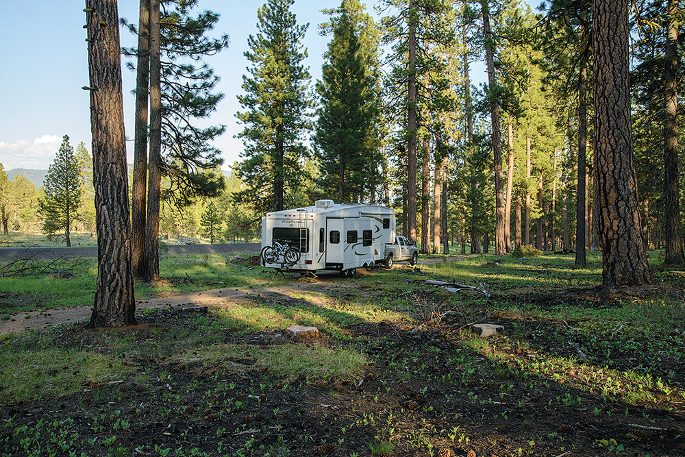
Central Oregon’s ponderosa pine forests create naturally shady campsites.
Bend Park and Recreation District
www.bendparksandrec.org
Cascade Lakes Scenic Byway and McKenzie Pass-Santiam Pass Scenic Byway
www.fhwa.dot.gov/byways/states/or
Crater Lake National Park
www.nps.gov/crla
Lower Crooked River Recreation Area
www.blm.gov/or/resources/recreation
McKenzie Pass Scenic Bikeway
www.rideoregon.com
Smith Rock State Park
www.oregonstateparks.org
Where to Stay in Bend
Bend/Sisters Garden RV Park
Top-rated Good Sam Park with paved RV sites, 30/50-amp hookups, Wi-Fi, fire rings, propane, pet walks, on-site fishing pond, heated pool and spa, nature trails and picnic areas. Nightly 10 percent discount for Good Sam Club members.
888-503-3588 | www.bendsistersgardenrv.com
CrownVilla RV Resort
Set in a quiet residential area, this big-rig-friendly RV resort has full-hookup sites on brick pavers, Wi-Fi and cable TV, tennis, shuffleboard, disc golf, a clubhouse and a fitness center. Pets welcome.
866-500-5300 | www.crownvillarvresort.com
Scandia RV Park
Family-owned RV campground with mature trees and green grass, full-hookup sites, Wi-Fi, cable TV, laundry facilities and a recreation hall. Walk to nearby
restaurants. Pets welcome.
541-382-6206 | www.scandiarv.com
 Trailer Life columnist and frequent contributor Emily Fagan has traveled full time by RV and sailboat with her husband, Mark, since 2007. The couple’s photos have appeared on more than 25 magazine covers and wall calendars, and Emily’s lifestyle, travel and how-to articles have been featured in more than a dozen RV and sailing publications. Follow their adventures on their blog, Roads Less Traveled.