The stallion turns and looks straight at us, ears perked, nostrils flaring, smelling our presence. One of about 250 mustangs in Wyoming’s White Mountain Wild Horse Herd, he stands about 100 yards off the road and, as I sit in my motorhome peering through my spotting scope, my heart races. He is all muscle and sinew and his dark reddish-brown coat, accented by a long, black mane and tail, shines in the sunlight.
We’d wanted to spend some time in Wyoming, but rather than head to the usual hot spots like Yellowstone, Devil’s Tower and the Grand Tetons¸ we craved less traveled roads. We opted for Sweetwater County, in the southwestern part of the Cowboy State that’s home to the firecracker-red Flaming Gorge, high desert vistas where Tyrannosaurus rex once hunted, some of the richest pioneer history in the country, and, of course, those magnificent wild horses.
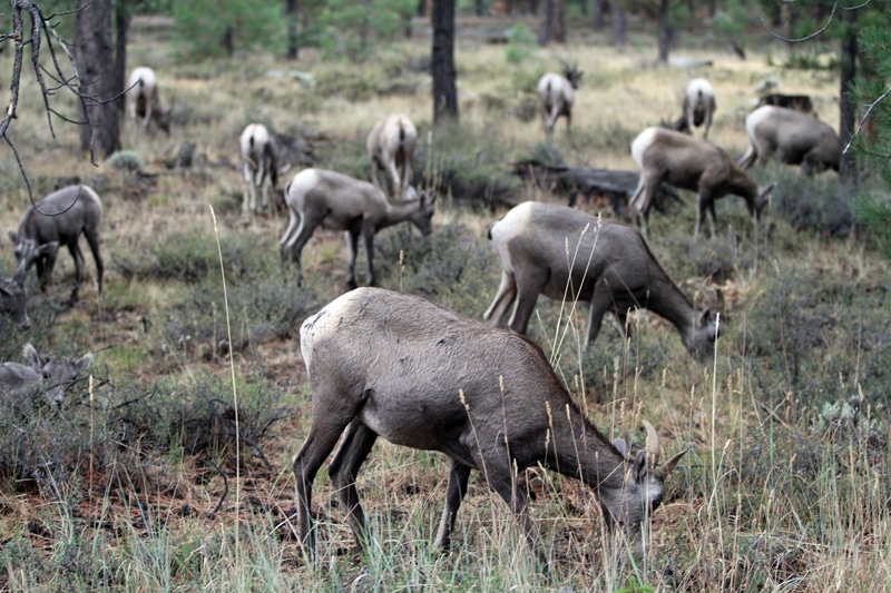
Rocky Mountain bighorn ewes and lambs graze near Red Canyon Visitor Center.
Traveling from Oregon to Wyoming is a long trek and we leave later than we’d planned. We streak through the night and arrive well past midnight at Mountain View RV Park in Baker City, Ore. This Western-themed park has been owned and operated by four generations of the same family since 1959 and it shows. It’s an oasis in the desert with shady trees and green grass, 73 sites (45 pull-throughs) with full hookups, laundry, showers, camp store, spa, outdoor pool and super-friendly management.
Refreshed, we spend the next day motoring across Idaho through desert landscapes the color of golden wheat, punctuated by the green of sagebrush, and fields filled with corn and alfalfa. Just outside of Boise, the land changes into towering, flattop plateaus, many of them crowned with basalt columns that resemble fortress walls.
Dark clouds gather and, as the sun sets just outside of Twin Falls, the black sky fills with the crackle of lightening; flashing ribbons of electricity hit the ground and brilliant sheets of lightening illuminate the sky. The wind picks up and the rain begins, softly at first and then in a torrent. At one point, the deluge is so heavy there are whitecaps on the water flowing down the highway and I can barely see so I hit the emergency flashers and drop the motorhome’s speed to 30 mph.
The storm follows us right into Green River, Wyo., where we pull the motorhome into the Tex’s Travel Camp, a bare-bones RV park right on the highway and both of us fall into exhausted dreamless slumber.
On to Flaming Gorge
We wake to brilliant blue skies and golden rocks in fantastical shapes that surround the little town that’s perched on the banks of its namesake river. The town boasts a historic train depot and a collection of surprisingly sophisticated public artworks along the city’s streets. It’s also the gateway to the Flaming Gorge National Recreational Area and, as we head out of town on Highway 530 south, we are treated to sweeping views of mountainous sagebrush country, billowy clouds, and blue skies that seem to stretch forever. We’re also immediately greeted by a herd of seven pronghorn antelope grazing along the road. Then there’s a lone buck and another small herd of females and babies. Throughout our Sweetwater journey, these graceful ungulates become our constant companions in the desert landscape.
The Flaming Gorge Loop is a scenic byway that’s approximately 160 miles long, encircling the 91-mile-long Lake Flaming Gorge and traversing the high desert plains of Wyoming and, to the south, the higher elevations of Utah’s Uinta Mountains. Along the way, visitors pass through lush forests and vast canyons carved by the Green River and travel back through geologic time on the way to the Uintah Basin of Utah.
We get our first glimpse of the reservoir and turn at Buckboard Marina, which offers water-view RV sites with picnic tables and fire rings, and a boat ramp. The wind shelters speak to the breezes blowing off the water and antelope wander through unoccupied campsites. We make a note that this would make a nice place to spend a day or two.
We pass through the green Lucerne Valley, obviously irrigated with water from the reservoir, and stop at the historic Linwood Overlook, the site of a former town flooded by the dam that created the lake.
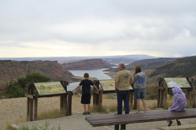
Winds that rise from the valleys near the summit prompt some visitors to bundle up as everyone gazes in awe.
We pass into Utah and, at the town of Manila, turn southeast on Highway 44 toward Flaming Gorge Dam and its visitors center. We are in the Ashley National Forest and every few feet a sign identifies the geologic formation and epoch we’re passing through – Jurassic, Entrada sandstone, alabaster from ancient tidal flats. It’s fascinating and makes us want to know more.
As we push deeper into Flaming Gorge, dark red cliffs that give the area its name rise up around us and the motorhome strains against the steep climb and high elevation (6,000-plus feet). As we gain elevation, juniper and pine replace sagebrush, followed by fir and white-trunked aspen. We stop at Sheep Creek Overlook to give the coach a break and take some panoramic photos of the reservoir and red canyon walls.
At Carter Creek, we pass a sign stating this is the site of Utah’s oldest fossils. We’ve traveled back in time more than 1 billion years.
We turn onto the road to Red Canyon Visitor Center and pass several lakes, including West Green Lake, and a number of primitive campgrounds with stellar canyon views. Along the roadside, a herd of Rocky Mountain bighorn sheep grazes, unconcerned about our passing. These animals were reintroduced to the area in 1938 and they’re thriving.
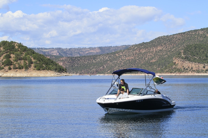
Flaming Gorge is a boaters’ paradise for fishing, water skiing or motoring the open waters.
The visitor center offers interpretive displays about the canyon and its animals along with drop-dead-gorgeous views of the water and cliffs below. All around the center are walkways and viewing spots perfect for photos. Below, speedboats, looking like toys, carve V’s in the sparkling water. Flaming Gorge is a dizzying 1,700 feet deep and 4,000 feet wide and, in many places, you can walk right to the canyon’s edge without fences to mar the view. We snap photos, hoping to forever capture the sense of grandeur we feel.
At Greendale Junction, we head north on U.S. Route 191 and meander down the canyon to Flaming Gorge Dam. Every 20 minutes, rangers give free, hour-long tours of the dam and allow visitors inside the power plant and onto spillway viewing platforms. It’s here we also learn that the lake is famous for great fishing – fish as large as 50 pounds have been landed. Next time, we’re bringing our poles.
The light is fading so we head for Mustang Ridge Campground, a lovely forested camp on a finger of the lake that offers electric hookups, showers and restrooms. Our paved site is large, private and surprisingly level, and we walk the dogs along the campground’s quiet roads.
The following day, we continue north on 191, and pause at Antelope Flat Overlook for one last look at the gorge. The viewpoint offers the sweep of the desert basin, sculpted by wind and weather, down into the blue reservoir and to the red soaring cliffs below.
Pioneer History and Wild Horses
We pass into Wyoming and back to sagebrush plains and flat-topped plateaus crowned with endless blue skies. This is spectacularly big country and it can be harsh and dangerous. The distances are great and RVers should make sure they carry plenty of fuel, water and food – just in case.
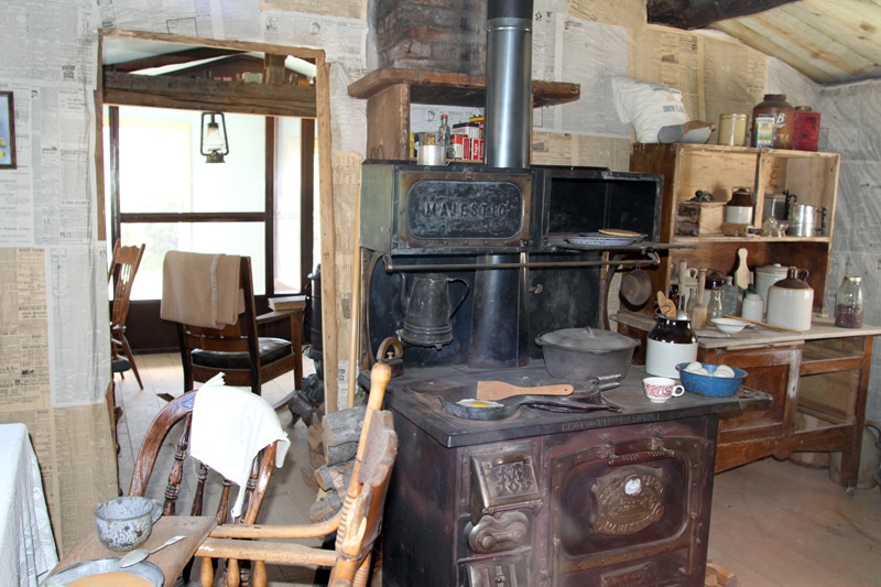
The restored interior of a miner’s home in South Pass City State Historic Site gives visitors a glimpse into this harsh life.
We pull off at the Art Gallery of Time overlook. These eroded bluffs and plateaus overlooking Little Firehole Canyon are relatively young – about 45 million years old. In contrast, the rocks down at Flaming Gorge Dam that form the canyon’s nearly vertical walls are 1.1 billion years old.
It’s only 70 miles from Flaming Gorge Dam to Rock Springs, but the mileage is deceptive because there are so many turnouts with great views and wildlife such as hawks and antelope that it takes us a few hours to make the journey. Once in Rock Springs, we follow the signs to the town’s historic district, a couple of blocks of turn-of-the-century buildings. It’s Sunday, so the museum, located in an impressive two-story stone building that used to house the city hall and fire station, is closed. But we meander down to the “Home of Rock Springs Coal Welcome” arch and a little greenway beside a historic rail depot that features an old caboose and a poignant memorial statue commemorating miners who lost their lives mining coal.
We head north out of Rock Springs toward the Farson crossroads of highways 191 and 28. Several important pioneer trails, including the Oregon Trail, the Mormon Pioneer, the Pony Express, and California National Historic Trail, parallel Highway 28 and there are historic markers and even original wagon ruts along the way. We pull out at False Parting of the Ways. As many as 500,000 people passed this way, braving untold hardships in their quest for new lives in the West. The two-lane dirt track of the Oregon Trail is clearly visible.
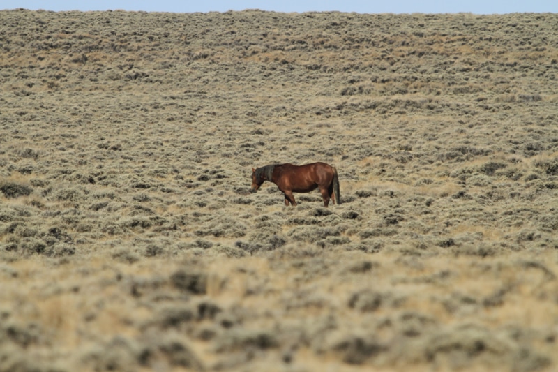
Our first sight of a wild mustang stallion on the Pilot Butte Wild Horse Scenic Loop felt thrilling.
We pass the Continental Divide (elevation 7,550 feet) and turn off at the old mining town of South Pass City, a state historic site that gives visitors a taste of life here in the 1860s. The town site boasts about two dozen original buildings, including old cabins, a general store, schoolhouse, livery stable, and several saloons filled with antiques and everyday items people who lived here would have used. In the store, shelves are filled with coffee, washing powder and canned fruits. Card tables in one of the saloons are set with glasses of beer and whiskey, a peeled hardboiled egg, and half-smoked cigars. It’s as if the miners and others who lived here have just stepped away. This summer, tours of the Carissa Mine, where residents worked, will resume.
It’s our last day in Sweetwater County and we’re up early to see the area’s famous wild horses. We drive south to Green River and onto Wild Horse Road, a 14-mile dirt and gravel track that runs between Green River and Rock Springs. Some people say it’s rare to spot the mustangs, but, just 10 minutes into our drive, we see the first one, a dark stallion with a light-colored mane. Then it’s two more and four more, a black, two reds and a gray. Before long, it’s 10 horses, then a dozen. We see 19 of these beauties, including my stunning red stallion with the thick mane and tail that stands close to the road and looks squarely at me. They are fat, healthy and wild equines that love Sweetwater County – almost as much as we do.
For More Information
Mountain View RV Park
541-523-4824, www.mtviewrv.com
Sweetwater County
307-872-3732, www.sweet.wy.us
Utah Travel Industry
800-200-1160, www.utah.com
Wyoming Tourism
307-777-7777, www.wyomingtourism.org