Fishing, hiking, geological formations and exploring the last silver boom town in the Centennial State make for as colorful a trip as the stunning fall foliage
I admit, I’m a fall foliage snob. I grew up in the Northeast, and I’ve always maintained that nothing is more stunning than a multihued forest of maple trees. However, after visiting the area around South Fork, Colorado, I’m reconsidering this opinion. As we discovered on a road trip there last fall, the aspens and cottonwoods, framed by the craggy San Juan Mountains to the west and the Teton-like Sangre de Cristo Mountains to the east, glow with such richness that the early miners who tramped this rugged region likely paused in their search for silver to ogle the glorious golden views.
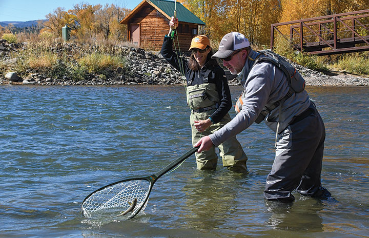
Anglers net a feisty fall brown trout on the Upper Rio Grande near South Fork. A stretch of the river between South Fork and Del Norte is classified as a Gold Medal trout stream. Photos by Jack and Lisa Ballard
Our road trip to southwestern Colorado came about quickly, thanks to an invitation to go fly fishing on the Upper Rio Grande. The source of the Rio Grande is in the San Juan Mountains, just east of the Continental Divide. Where the south fork of the river meets the main stem, at the town of South Fork (population 604), the flow is 50 yards wide with many riffles, small rapids, gravel bars and eddies. Both rainbow trout and brown trout were originally stocked here by the state of Colorado but have now naturalized. They get big, particularly in a stretch of water between South Fork and Del Norte. The chance to cast for them got our wheels in motion.
Trout Fishing on the Rio Grande
When we arrived the river was about half its normal level. A couple of drift boats and rafts bumped along the deepest channel, but we opted for wading. Most of the fish we netted were small, about 12 inches. The brown trout were particularly plentiful and gorgeous. Their flanks were as golden as the aspen and cottonwood leaves that draped over the riverbanks and floated by in the chilly, crystalline water.
We spent the morning working our way south from the Rio Grande Club, a golf resort in South Fork, for a half-mile. Then we drove northwest to the 579-acre Coller State Wildlife Area, a popular spot for wildlife watching, picnicking and hunting, but we were focused on the fishing. After landing another half-dozen fish, we yearned for some lunch, so we packed up our tackle and continued north a few more miles to Creede, a historic mining town wedged into a narrow, cliffy valley.
Creede Historic Mining Town
Driving down the main street of Creede (population 260), one straddles the old and the new. Enticing cafés and galleries have sprung up among the tumbledown miners’ cabins. This tucked-away town is in the midst of a resurgence, and not for the first time.
Silver was first discovered near Creede in 1869 but extracting it from those early claims proved unprofitable. Over the next two decades, a few homesteaders moved to the area as a result of the stagecoach line rather than mining prospects. Then, in 1889, Creede’s fortunes changed, with the discovery of purer mineral deposits in Willow Canyon, just beyond the town, deeper in the mountains.
A brief boom ensued, during which the population of Creede ballooned to 10,000 people, but it lasted only four years. In 1893, the Silver Panic caused silver prices to plummet. Most silver mines in Colorado closed, but Creede survived by mining gold, lead, zinc and copper. That said, the silver mines stayed open until the 1960s. Over the life of the silver mines, 870 metric tons of this precious metal were pulled out of the ground.
After poking around the small mining museum at the entrance to Willow Canyon, we made our way along the 17-mile Bachelor Loop, a self-guided driving tour through the heart of Creede’s mining district that’s both ATV- and RV-friendly. We wound our way up the well-maintained dirt road past numerous old mine shafts, the remains of railroad bridges and the impressive Humphrey’s Mill, where silver ore was processed during the early 1900s. The massive gravity-fed mill employed 1,000 men during its heyday. Today, Bachelor Loop preserves a piece of Western heritage, transporting casual observers to an earlier century and an important period in Colorado’s history.
Elephant Rocks
Anxious to get some exercise, the next day we looked for a place to go hiking. A couple of the locals in South Fork suggested checking out Elephant Rocks and then climbing up to La Garita, a natural arch, both northeast of town. As we planned to head east anyway to explore Great Sand Dunes National Park and Preserve, Elephant Rocks sounded like a perfect pitstop en route.
Elephant Rocks are an outcropping of boulders near the town of Del Norte. It was fun to scramble on top of the rounded rocks that resembled the backs of a large herd of elephants. Even more fun was looking for birds among the pinyon pines and scrubby junipers. Rock wrens, green-tailed towhees and pinyon jays were among the many species that we spotted in this high, dry scrubland.
La Garita Natural Arch
Our hiking appetites whetted, we continued to La Garita Natural Arch. Though technically in La Garita Wilderness, a dirt road that allowed vehicles ended at its base. It was a quarter mile and 150 vertical feet from the small parking area to the giant stone ring, but it felt near vertical. The climb was worth it for the panoramic views of the towering Sangre de Cristo Mountains across the San Luis Valley.
“I’ll take your picture by the arch,” offered my husband, Jack, but I couldn’t stand still. I leapt for the joy of it as he snapped a few frames.
Afterward, still eager to hike more, we headed to nearby Penitente Canyon, for yet another lesson in southern Colorado landscapes and history.
Penitente Canyon
During the early to mid-1800s, pioneers and pack animals traveled along the Old Spanish Trail, a trade route from Santa Fe, New Mexico, to Los Angeles, California, that swung north into this part of Colorado. Penitente Canyon was part of that path.
Jack and I opted for the 2.5-mile Penitente Loop Trail which went through the heart of the canyon and then circled back on an open plateau. As we broke out of the narrow, winding chasm onto the arid plain, we could see wagon-wheel ruts from the pioneer era carved into the sun-bleached rock.
The wagon trains weren’t the earliest people to pass this way. Indigenous people traveled through Penitente Canyon more than 2,000 years ago, as evidenced by the pictographs preserved on the canyon’s walls. Nowadays, in addition to hikers, rock climbers flock to the canyon, which looks like a natural climbing gym. It’s a rock hotspot with hundreds of routes, appealing to all ability levels.
Great Sand Dunes National Park and Preserve
Our last stop on our Southern Colorado sojourn was Great Sand Dunes National Park and Preserve, the geological phenomenon at the point where the San Luis Valley bumps into the Sangre de Cristo Mountains. My goal was to hike to the top of Star Dune (elevation 8,617 feet). It is the tallest dune in the park and thus the tallest dune in North America.
“Go for it!” urged Jack, who opted for a nap. He had already climbed the dunes a number of years ago.
The park’s dune field spreads across 30 square miles. It’s a place of extremes. During the summer, surface temperatures of 150 degrees Fahrenheit bake the sand. During the winter, that same spot might be minus 20 degrees F. On my dune-climbing day, it was chilly, in the 30s, and the wind howled.
Wind is a key part of the dune ecosystem. The prevailing winds from the southwest pick up sand from as far away as the San Juan Mountains (65 miles) and slam it into the wall of the Sangre de Cristo Mountains. As northeasterly winds blast through the mountain passes, the sediment piles back on itself and then gets washed back onto the arid plain with the spring snowmelt. The cycle has repeated for more than 400,000 years.
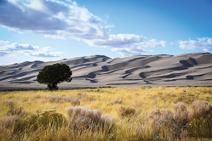
The wind constantly reshapes the dune field at Great Sand Dunes National Park into mesmerizing waves.
When I stepped onto the pale, talc-like surface of the dune field, the wind nearly knocked me off my feet. I zipped up my collar to prevent my cheeks from getting sandblasted, then put a shoulder into the wind. It was tough going. The fine grains gave way under each step.
The first quarter mile was pancake flat, then the climb began. Though the climb sounded modest, 3.8 miles and about 750 feet of vertical gain, it felt three times higher due to the loose footing. Luckily there was entertainment along the way.
Much like a snowy slope, some people sledded down the dunes while others stood on snowboard-like boards without bindings. I watched one gal face plant, as her friends laughed from the launching point. “Want to try?” asked one of the onlookers offering me a sand board. I declined, continuing my climb.
When I finally reached the top, I marveled at the waves of sand that flowed around me, framed by the rock face of Mount Herard, a 13,000-footer at the northwestern edge of the dune field. Then I boot-skied down.
The dune field contains more than 5 billion cubic feet of sand. About half of that poured out of my hiking boots when my hike was over, but what a unique experience! As I watched the pale grains drain from my boots, I reflected back on the many unexpected, welcome parts of our trip. The area around South Fork, Colorado, is beautiful and largely undiscovered. We loved the limitless outdoor opportunities there. And it’s RV-friendly. You can bet we’ll be back.
More to Know
The town of South Fork is high, 8,200 feet. Many of the historic sights and recreational activities are higher than that. Respect the elevation by staying rested and hydrated. Plan more time for hiking and other aerobic activities because you will be out of breath more quickly. If you feel nauseous or have a headache, head lower to avoid acute mountain sickness.
If you go to Elephant Rocks, avoid towing a trailer past the information sign at the entrance. It’s a narrow dirt road without an adequate turn-around spot.
If visiting La Garita Arch, a four-wheel-drive vehicle with higher clearance than a passenger car is highly recommended. Check with the forest service office in Del Norte for road conditions.
Bring a bandanna or a buff, and sunglasses — preferably the kind that wrap around — to protect your face and eyes from sand and sun on the dune field at Great Sand Dunes National Park.
Creede Visitor Center and Chamber
www.creede.com
Great Sand Dunes National Park and Preserve
www.nps.gov/grsa
San Luis Valley Tourism Office
www.sanluisvalley.org
South Fork Anglers (fishing info and guides)
www.southforkanglers.com
South Fork Visitor Center
www.southfork.org
Stay and Play
With a plethora of RV parks and campgrounds and fewer people than the more well-known destinations in Colorado, there are many options in the area after Labor Day, including these four forest service campgrounds and several RV parks.
Creede (Divide Ranger District)
719-658-2556
Del Norte (Divide Ranger District)
719-657-3321
La Jara (Conejos Peak Ranger District)
719-274-8971
Saguache (Saguache Ranger District)
719-655-2547
www.fs.usda.gov/recarea/riogrande
Creede
Mountainviews at Rivers Edge RV Resort, located in the San Juan Mountains along the banks of the Rio Grande River, has 97 level full-hookup sites to accommodate any size rig, a stocked trout pond, a pet area and pet wash. Open May through October, there’s also an on-site gift shop and fitness center.
mountainviewsrv.com
Mosca
Located just outside the entrance to Great Sand Dunes National Park and Preserve is Oasis Campground with 20 pull-through, full-hookup RV sites. Oasis offers sand board and sled rentals, and is open April 1 through October 15.
www.greatdunes.com
South Fork
South Fork Campground, a pet-friendly Good Sam Park that is open May 1 through October 1, has large shaded sites along the Rio Grande, laundry facilities, a country store and a playground.
www.southforkcampground.com
A Good Sam Park, Alpine Trails RV Park is open May through mid-September (depending on snow) and has 42 full-hookup sites and offers overflow parking for Jeeps and side-by-side off-road vehicles.
www.alpinetrailsrvpark.com
Trailer Life columnist Lisa Ballard (with her husband, Jack) explores the outdoors and camps throughout North America while on assignment and for fun. A freelance writer and photographer since 1991, Lisa’s work has appeared in hundreds of magazines, websites, calendars, billboards and on vehicles…anywhere words or images appear. She has written 11 books, including six guidebooks, and recently her first children’s book, Gasparilla, A Pirate’s Tale. Ride along with her at www.lisaballardoutdoors.com.