The Sonoran Desert offers an impressive array of colorful flora and fauna, scenic drives and outdoor recreation — all a stone’s throw from the urban sprawl of Phoenix
The central Arizona region of the Sonoran Desert is a lush landscape full of exotic vegetation, unusual wildlife, colorful flowers and even a few rivers and lakes. Best of all, this natural beauty is very accessible, even for RVers staying within the city limits of Phoenix and Scottsdale. It is no wonder that snowbirds flock to Arizona every winter to escape the northern blizzards and enjoy the wonders of the desert.
Phoenix is the sixth largest city in America, and it sits on a massive, flat expanse of land that is dotted with ancient volcanic mountain peaks jutting up from the desert floor. Many of these hillsides have been set aside as recreation areas for the public, and there are huge hiking, biking and horseback-riding trail systems just a few miles in every direction from the heart of the city.
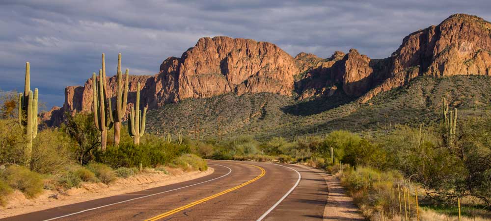
The Bush Highway scenic drive follows through some of the most scenic landscapes in central Arizona. Photos: Emily and Mark Fagan
For decades, urban Phoenicians have taken to the outdoors at lunch and after work on the popular trails at South Mountain and Piestewa Peak in Phoenix, and on Camelback Mountain next door in Scottsdale. In recent years (even as recent as last year), the extensive Sonoran Desert Preserve and McDowell Sonoran Preserve trail systems in these cities have been enlarged with new trails.
Miraculously, it takes just a few steps on any trail for the chaos and clamor of the city to vanish behind. These trails are wonderful places to commune with cactus wrens, cottontail rabbits and the many species of cactus, especially the saguaro cactus that stand tall with their arms raised high as if they were being held up by a Wild West stagecoach robber.
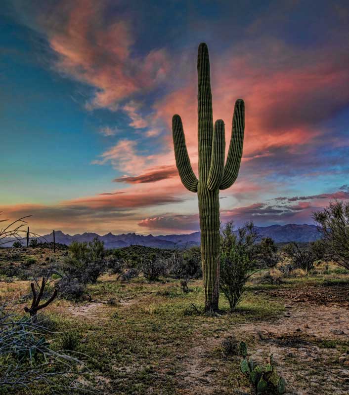
The saguaro cactus stands tall in the desert region.
For RVers staying in Phoenix or Scottsdale, these urban trails make for an ideal excursion, but the real treasures of the Sonoran Desert are but a short drive and just a few miles farther east of the metro area. On a recent trip, my husband, Mark, and I used Mesa, Arizona, as a home base for exploring the wild side of Arizona’s deserts, and we spent many a happy day discovering the gems of the Sonoran Desert that lay just beyond our RV site.
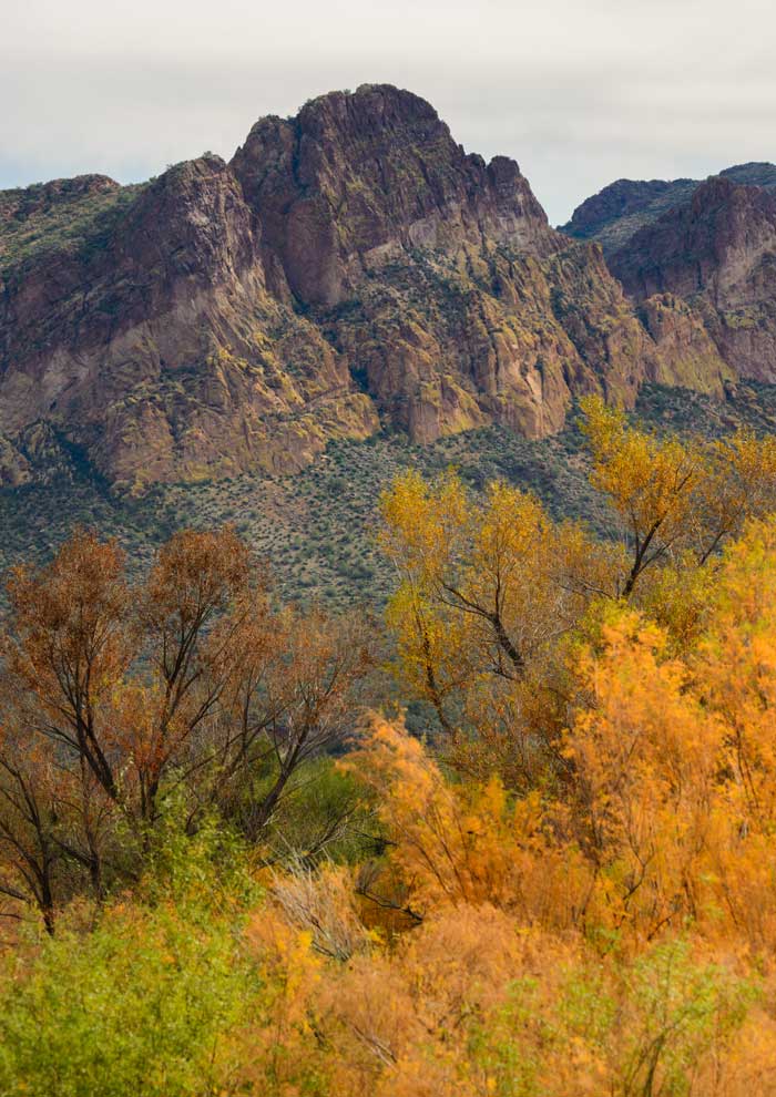
Autumn brings a blaze of fall foliage to the Sonoran Desert.
One of our favorite daytrips was a drive along the extraordinary Bush Highway, which runs between state routes 87 and 202 northeast of Phoenix. This stunningly scenic drive follows the pretty Salt River through some of the most eye-popping landscapes in central Arizona. Although this state isn’t known for having four real seasons, when autumn arrives in late November and December, the whole area erupts in vivid fall colors, and nowhere are they more vibrant than along the Salt River.
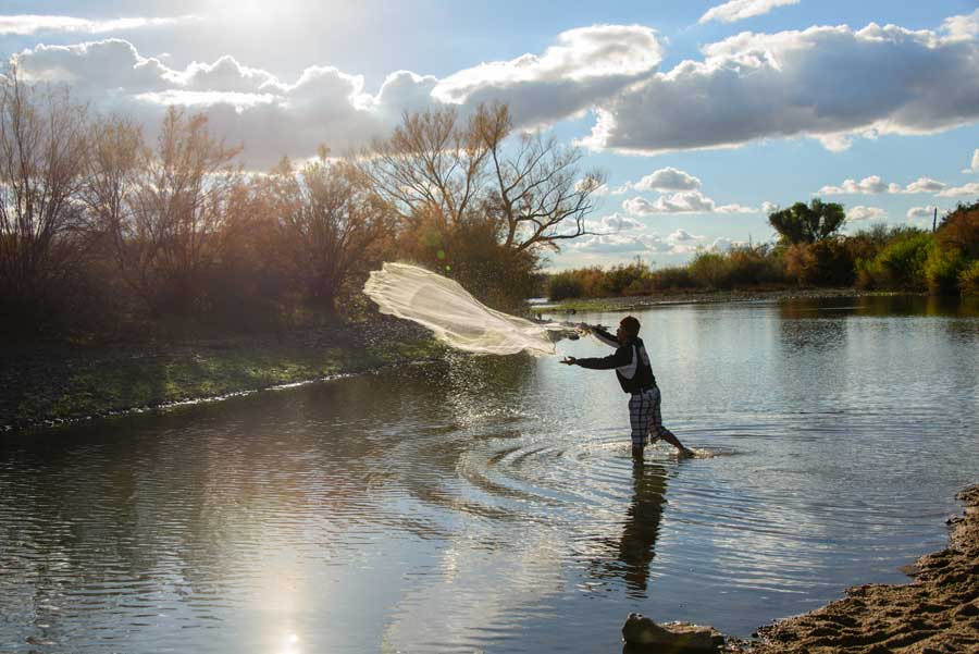
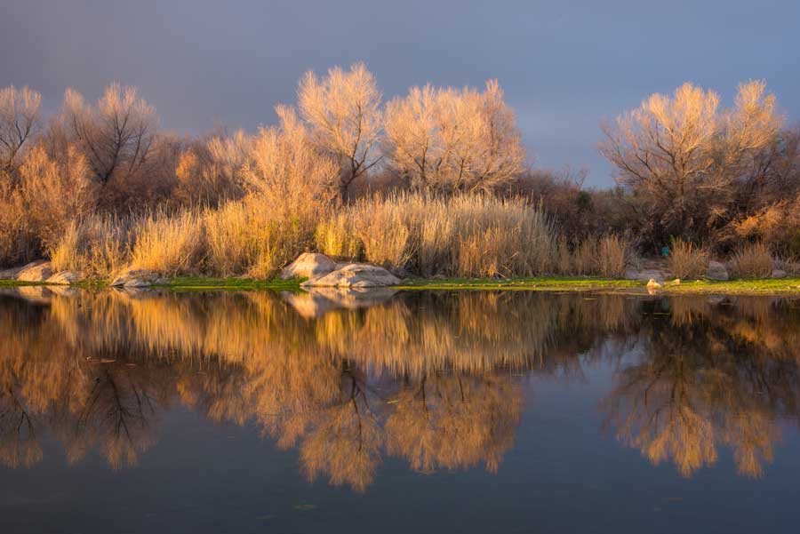
We stopped at the Blue Point Picnic Area and walked along a trail on the banks of the Salt River. Looking back across the water toward the mountains, the bushes and trees flashed brilliant gold and orange in the setting sun. High up on a rock precipice, a great blue heron stared down at us while a fisherman stood in the middle of the river casting his net. It was hard to believe we were just 30 miles, as the eagle flies, from the high-rise office buildings of downtown Phoenix.
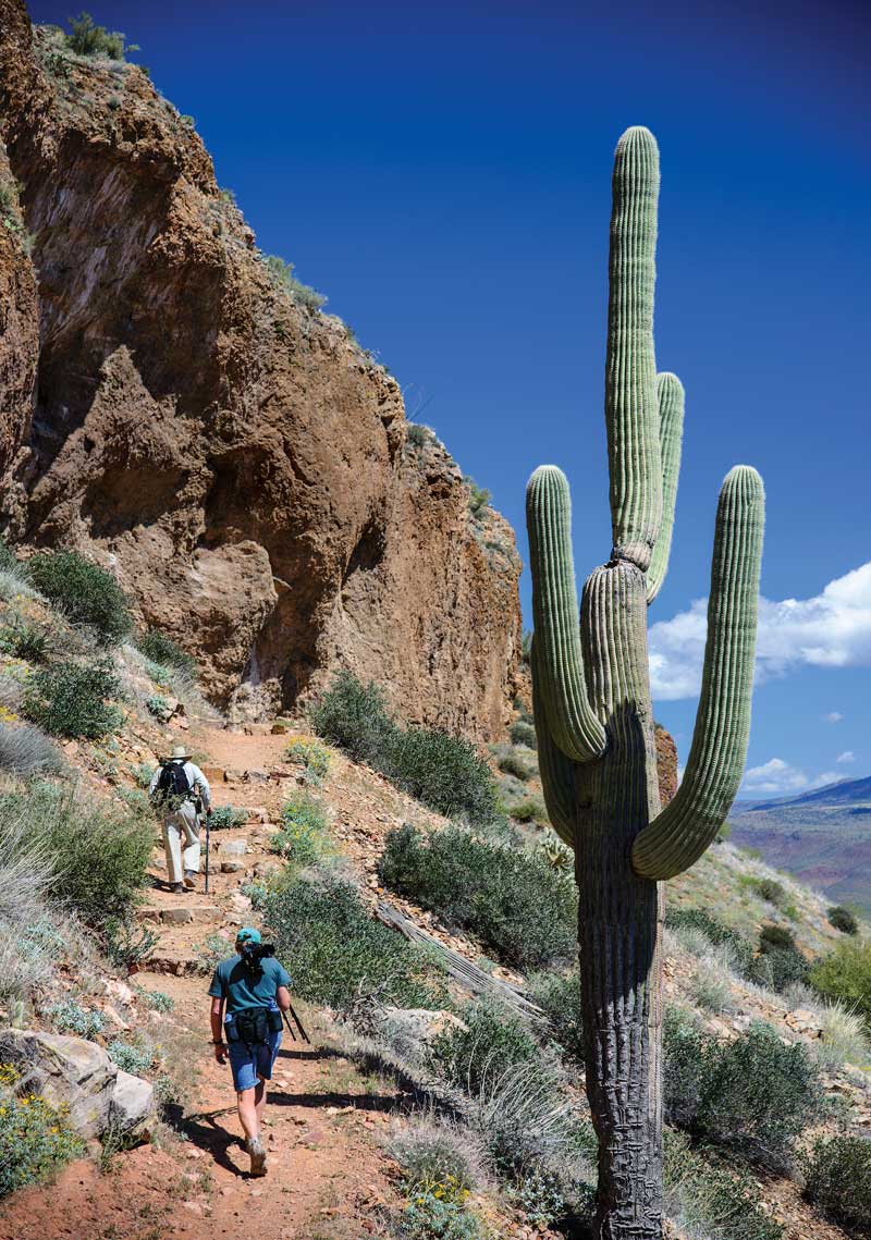
Hikers climb to the Upper Cliff Dwellings at Tonto National Monument.
As we hiked back to our rig, a winter storm began to brew, and the sky turned black. An eerie light from the glowing sun and dark sky filled the valley. On the northeast horizon in the distance, we could see that it was raining in torrents, and as the sun fell lower in the sky a huge rainbow appeared above the forest of saguaro cactus before us. We held our breath watching this magical scene unfold as the rainbow glowed brighter and brighter over the cactus.
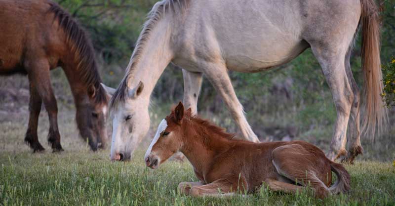
Wild horses and their colt graze on the desert grasses.
A herd of a hundred or more wild horses calls this area east of Phoenix home, and they can often be seen at the various scenic overlooks along the Bush Highway. We were very lucky one afternoon to follow a trail from the Stewart Mountain scenic overlook and come across a mare and stallion grazing with a very young colt. The colt couldn’t have been more than a week old or so, and its spindly legs and knobby knees were adorable. The mare raised her head for a moment to give us a quick glance, but she wasn’t too concerned with our presence. These horses are popular, and they are used to being in the spotlight; we later met a production crew that was filming them for a special program on the Travel Channel.
The Sonoran Desert region east of Phoenix, Arizona, is laced with many beautiful waterways, including the Salt River.
A little farther east on the Bush Highway is an entirely different habitat, where the Salt River was dammed to form lovely Saguaro Lake. Here the arid desert gives way to a big lake whose waves lap lazily on the shore. There is a marina at one end of the lake, and on weekends the boating community is very active with lots of locals taking their small power and sailboats out for a spin.
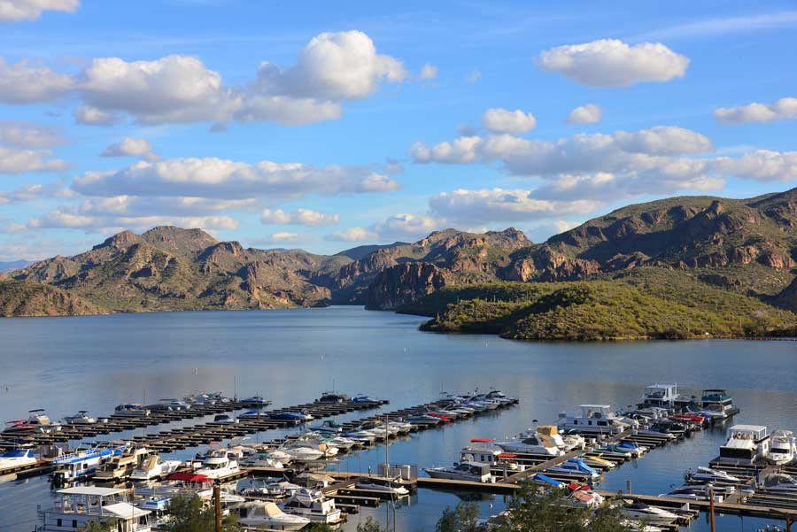
The Salt River was dammed to form lovely Saguaro Lake, which has a marina and is the launching point for guided tours on the Desert Belle double-decker boat.
Tourists can enjoy the water aboard the Desert Belle, a double-decker boat that gives guided tours down the long, skinny lake into the canyons where the desert hillsides rise up from the shore. Spotting a bald eagle soaring on the thermals was a high point on our excursion. Back at the marina restaurant, a tasty cheeseburger and a beer on the deck with a fantastic view of the lake made a perfect lunch stop. What an ideal place to take a selfie to send to friends back home who are shoveling snow!
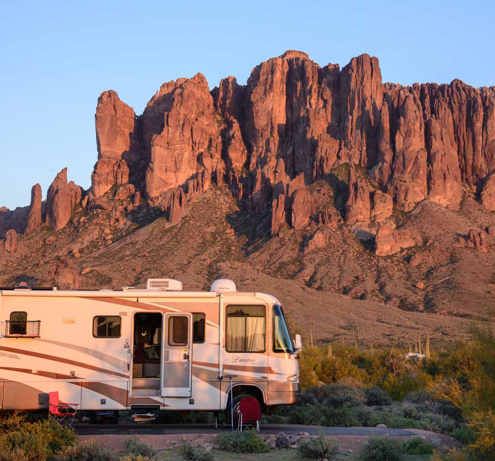
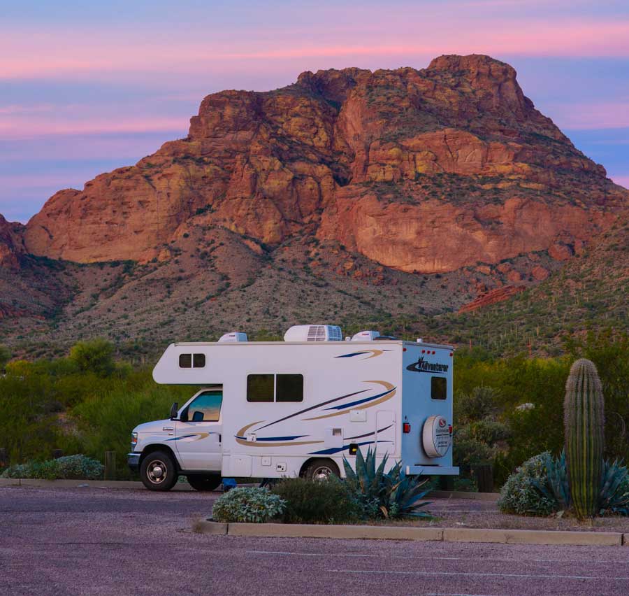
The Superstition Mountains provide a stunning, dramatic backdrop to the campsites at Lost Dutchman State Park in Apache Junction.
For RVers who want to be immersed in the beauty of the Sonoran Desert, there are three outstanding public campgrounds with paved loops, sites big enough for large motorhomes and electric and water hookups: McDowell Mountain Regional Park, Usery Mountain Regional Park and Lost Dutchman State Park. Each has an RV dump station to empty the holding tanks at the end of your stay.
The beauty of staying in one of these parks is that there are great hiking trails and gorgeous Sonoran Desert scenery right outside your door. A hummingbird feeder will attract cute crimson-headed hummers within an hour, and a shallow dish of water on the ground will bring songbirds and small critters. These are all extremely popular spots for RVers in the winter months, and advanced reservations are highly recommended.
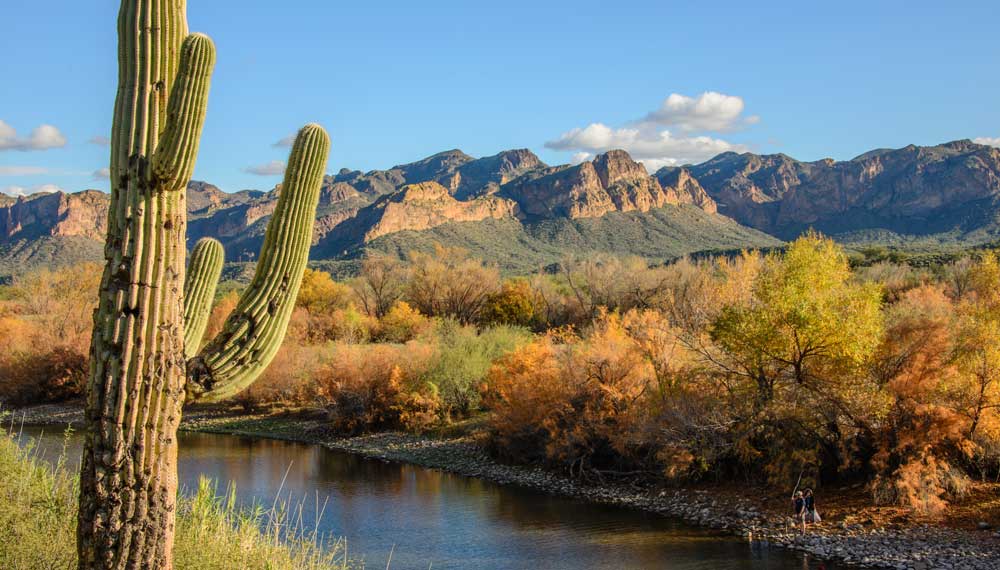
The whole area erupts in vivid fall colors along the Salt River.
McDowell Mountain and Usery Mountain regional parks feature wonderful mountain-biking and hiking-trail systems, offering both easy and challenging loops for all skill and fitness levels. Our favorite hike was the Wind Cave Trail at Usery Mountain Regional Park. We followed the trail to the top of the mountain that flanks the park, and the views at the top were worth every huff and puff it took to get there. The little chipmunks at the summit were very cheeky, and few hikers could resist sharing a crumb from their sandwich or protein bar with these little guys. We hadn’t noticed before our hike that lichen covering all the sheer rock walls gave the cliffs a yellow tint, even from ground level; however, those amber rock walls soon became an easy landmark for us to spot as we drove around the area.
Lost Dutchman State Park is a perennial favorite among snowbirds, and the entire park is presided over by the majestic Superstition Mountains. During our stay, we could take in a fabulous view of the column-like cliffs right from our RV window. At dawn each morning we woke to the haunting cries of the Gambel’s quail, a wistful call that gives the desert an almost melancholy air. These small, pudgy birds wear a single black feather as a topknot on the top of their heads, and we got a kick out of watching their little feather headdresses bobbing around as they scampered across our site.
There is an unexpected calmness to be discovered just outside the hustle and bustle of Phoenix and Scottsdale.
Located in Apache Junction, Lost Dutchman State Park marks the beginning of the incomparable Apache Trail (state Route 88), a scenic drive that goes through some of the most pristine and awe-inspiring Sonoran Desert terrain in the state. You’ll need to leave your motorhome at the campground and take your dinghy on this route. A significant portion of the byway is unpaved, though the first 20 miles of the Apache Trail is paved and winds between hills and valleys filled with saguaro, prickly pear and cholla cactus. After passing the vivid blue waters of Canyon Lake, you’ll encounter the little town of Tortilla Flat, population 6. There is a U.S. Forest Service campground here, open October through April, with water and sewer hookups and a dump station. Shortly after leaving town, the road turns to dirt for the next 20 miles and continues its weaving path through exquisite desert landscapes and passes a breathtaking viewpoint high up on a plateau.
This dirt road is not recommended for large RVs, as it is narrow and goes through many twists and turns. For intrepid drivers, the reward in the middle is a dramatic view of Apache Lake from high above, and the reward at the end is the engineering marvel of Roosevelt Dam. This dam, built in 1911, holds back the Salt River to create Roosevelt Lake. Where Saguaro Lake is long and skinny, Roosevelt Lake is broad and wide, and high up on its southern shore is Tonto National Monument, home to ancient Native American cliff dwellings that were built by the Salado people 600-800 years ago. At the end of Route 88, take a right on state Route 188 and drive for 3 miles to Tonto National Monument on the right.
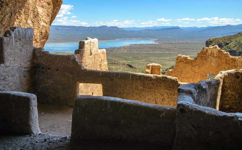
The evocative ancient Anasazi cliff dwellings at Tonto National Monument have a view of Roosevelt Lake.
There are two levels of cliff dwellings at Tonto National Monument, and the lower cliff dwellings are open for all to see. After climbing the steep path up to the ruins and ducking under the low doorways within the dwellings, we peered down at the valley below us and marveled at how these people managed to sustain life in such a high place. They must have been extremely fit! The upper cliff dwellings can only be viewed on a guided hike with a ranger on certain days and at certain times. We took the excellent $3 “Photo Tour” hike to see them. Panting by the time we got up there, we realized that if hauling water from the river hundreds of feet below to the lower cliff dwellings had been a challenge for those ancient people, getting water to the upper level must have been a gargantuan task!
From Tonto National Monument travelers have two options: Either return to Lost Dutchman State Park by retracing the route or continue on in a loop through Globe along Route 188 and U.S. Highway 60. If you choose to drive the loop, there is some attractive scenery along the way, but it’s nothing like the awe-inspiring sights you have already enjoyed on the Apache Trail. Besides, your shutter fingers have probably grown weary from taking so many photos.
Vibrant and colorful sunsets are a natural part of everyday life in this exotic corner of the world.
If the word “desert” has always evoked images of camels and vast sand dunes for you, take your motorhome to the Sonoran Desert in central Arizona, and discover the color and vitality of this unique place!
GETTING THERE: Phoenix is located in south-central Arizona. It is accessible from the north via Interstate 17 and via Interstate 10 from all other directions. Phoenix is 150 miles from Flagstaff, 110 miles from Tucson and 300 miles from Las Vegas.
FOR MORE INFORMATION
Eagle View RV Resort
480-789-5310, www.eagleviewrvresort.com
Lost Dutchman State Park
480-982-4485, https://azstateparks.itinio.com/lostdutchman
McDowell Mountain Regional Park
480-471-0173, www.maricopa.gov/parks/mcdowell
Tonto National Monument
928-467-2241, www.nps.gov/tont
Usery Mountain Regional Park
480-984-0032, www.maricopa.gov/parks/usery