
Photo opportunities abound in and around the town of Bishop, California
In our years of travel writing, I have made a number of writer pilgrimages. I have gazed at the items on Mark Twain’s mantle that launched evening tales to amuse his children. I’ve placed a stone at the site of Henry David Thoreau’s cabin at Walden Pond; walked the paths of Jack London’s Ranch; and bowed my head at the final rests of Hawthorne, Emerson, Thoreau and Louisa May Alcott at Concord’s Sleepy Hollow Cemetery. So, when my photographer husband, George, started to channel Galen Rowell’s spirit, I was more than ready to reciprocate and pack my bags for Bishop, California.
A world-renown outdoor photographer and adventurer, Galen Rowell’s impact and creative eye invigorated the art of landscape photography. More than a decade after his tragic death in a plane crash, his work remains a mainstay in print media. On Bishop’s Main Street, Mountain Light Gallery still exhibits his fine Sierra work and offers popular photography workshops with leading professionals.
Of all the magnificent places in the world, Rowell chose remote Bishop to make his home. The picturesque Owens Valley, the contrasting alpine and desert landscapes, and the 14,000-foot Sierra Nevada and White Mountain guard offered him the ideal studio. The area is an important touchstone to photographers, and these days nearly everyone is a photographer.
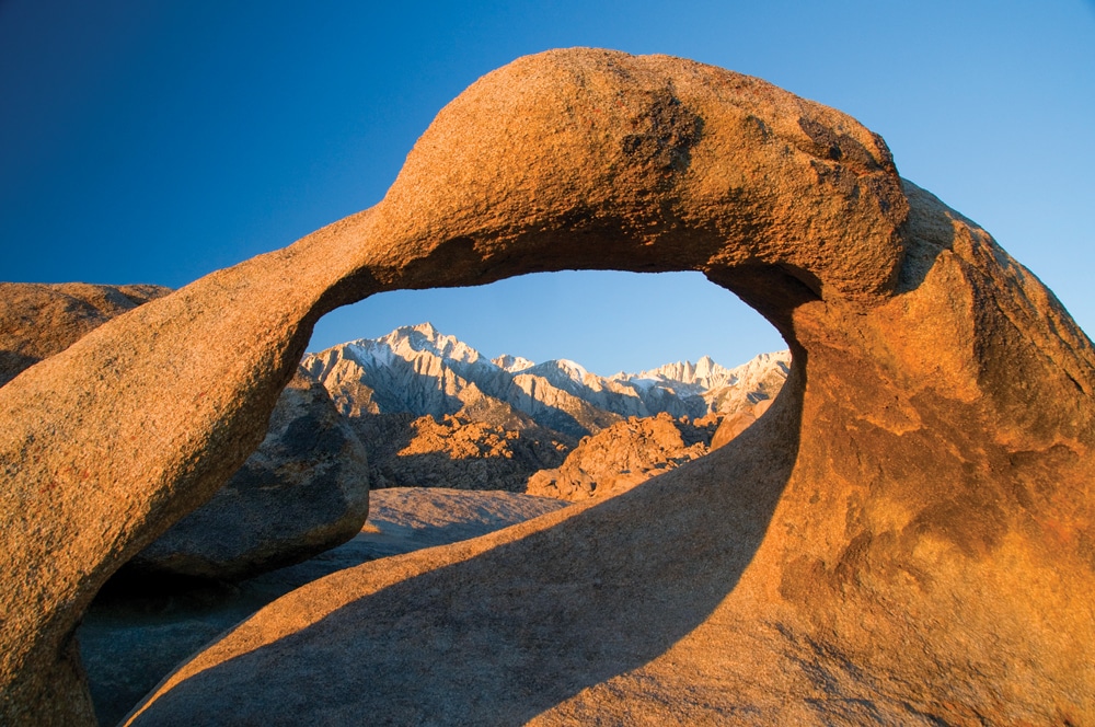
Mobius Arch, accessed by a moderate hiking trail in Alabama Hills Recreation Area, offers the perfect frame for the mesmerizing sight of Mount Whitney.
U.S. Highway 395 – the Eastern Sierra Scenic Byway and Birding Trail – is the artery to inspiration. Subject destinations stretch from the Nevada border to Death Valley National Park. When you visit, plan to tap in to your adventurer’s soul, exploring heights and dirt roads less-traveled. Having access to a dinghy vehicle expands opportunity and greatly eases mobility. Some locations are simple drive-to destinations, while others offer boot-to-trail discovery. But even at valley level and paved surface, you’ll find stunning subjects.
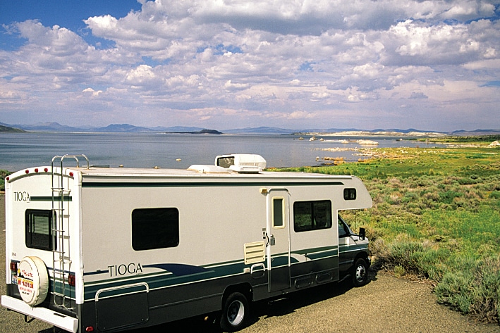
Area camping falls short of high-end extravagance, but comfort is within reach. For more primitive stays, the backdrop usually compensates for “roughing it.” RV campgrounds can be found in Bishop, Big Pine, Bridgeport, Independence, Lone Pine and Lee Vining. But do your research, as some are dry camps and others cannot accommodate large rigs. Smaller BLM and USFS camps put you next door to shoots. Come prepared for wind and sun, carry water and keep fuel tanks topped.
The listed outings will get you started. Finding the light and soul is up to each photographer.
Owens Valley
An ancient river and lake system, and lava, fashioned this picturesque valley in the rain shadow of the High Sierras. Ranching, mining and rail sponsored its dotting of small towns, with Bishop being the largest. Bounded by forbidding heights, the valley suggested a natural passage for Native American migrations, wagon roads, railroads and now U.S. 395. Grasslands, wetlands, lakes and volcanic cones, craters and tablelands create vital wildlife habitat. Small museums, rustic structures, fences, one-room schoolhouses and the historic Mono County Courthouse in Bridgeport or the Inyo County Courthouse in Independence lend photographic detail.
Ancient Bristlecone Pine Forest
The ear-popping heights of the White Mountains, east of Bishop, hold some of the world’s oldest living trees. Twisted, runted (less than 25 feet tall), sand-polished and defying the elements, these trees sunk root when the great pyramids were erected in Egypt. The Methuselah Walk strings past members of the 40-century club, including Methuselah. A new recordholder tops 50 centuries of life, and snags can linger a thousand years beyond even these generous lifespans. What self-respecting photographer could pass up an alpine desert of gravelly white sand, an incomparable blue vault and such weird living sculptures?
From U.S. 395 near Big Pine, head east-northeast on State Route 168 to follow climbing White Mountain Road, paved to Schulman Grove and passable dirt road (no motorhomes) to Patriarch Grove. Self-guided nature trails at Schulman Grove and Patriarch Grove welcome strolling. Methuselah Walk is a more demanding 4-mile hiking loop.
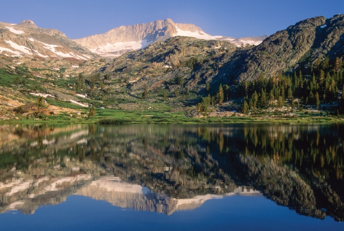
Time for quiet reflection awaits at Sawmill Lake on Bennettville Trail in Inyo National Forest.
High Sierras
The weather-making Sierra Nevada range stretches nearly 2 vertical miles above Owens Valley. Dramatic and uncompromising, the range has attracted the world’s best photographers, including Ansel Adams and Galen Rowell. Flowing and standing waters, chiseled peaks, high meadows, naked boulders, exposed rocky heights and high timber compose award-winning subjects. The mountains achieve heightened beauty with brewing storm, awakening and waning light and seasonal brush strokes. Most any east-west highway through the mountains promises grandeur. Whitney Portal (out of Lone Pine) and Onion Valley (out of Independence) are two paved, switchbacking swallow-hard high routes. Whitney Portal Recreation Area has no motorhome parking but does have reservable RV sites (family sites; no hookups in the facility); Onion Valley Campground’s RV sites are 25-foot maximum. Smaller is better.
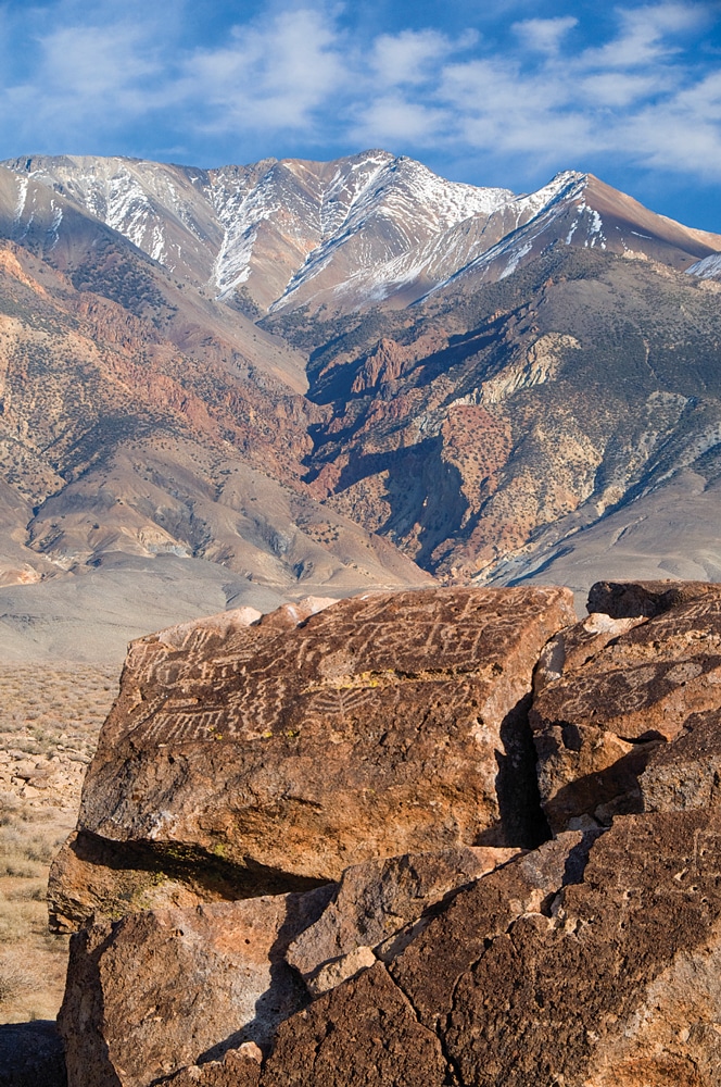
Fish Slough Bureau of Land Management ACEC combines red-rock petrogylphs with stunning views of the eastern Sierra Nevada.
Fish Slough BLM Area of Critical Environmental Concern (ACEC)
At the edge of the Great Basin, in a volcanic tableland that starts 5 miles north of Bishop, seekers of the road-less-traveled can find a trio of exceptional rock-art sites. Each jumble – warped and cracked – stands as a tablet to a bygone time, recording geologic processes and the passage of early travelers, most recently the Owens Valley Paiute Indians.
Crowding the dark volcanics are petroglyph images of hunters and animals. Look for paw, hand and foot prints, as well as suns, dots, masks and geometric forms. Some consider the art spiritual, others hunting magic because of nearby game trails. Overcast days typically improve shooting. Because shadow and light can hide or overpower some images, photographers should seek different perspectives.
Slough marshes and shade pockets of willows and cottonwoods accentuate the desert, making the ACEC a Watchable Wildlife Area. Travel is on a good graded dirt road suitable for dinghy vehicles; the rock-art sites are only steps from parking areas.
Mono Lake
Off U.S. 395 near Lee Vining, cinder cones and craters break the valley floor, low veils of steam announce area hot springs, and giant calcium-carbonate (tufa) towers scatter the lakeshore of the magnificent blue orb of Mono Lake. With the ancient lake having no outlet other than evaporation, concentrated minerals have rendered it three times more saline and 80 times more alkaline than the ocean. When this chemistry combined with percolating bottom springs and receding depths, the peculiar and grand cavelike structures found the light of day.
The brine shrimp and brine flies nurtured by the chemistry feed nesting California gulls and 70 species of migratory bird and waterfowl. The doubling reflections amplify the magic.
Mono Lake Committee and Mono Basin National Forest Scenic Area visitor centers have materials to spark ideas and staff to point the way. Mono Lake County Park and the South Tufa Area are within easy reach.
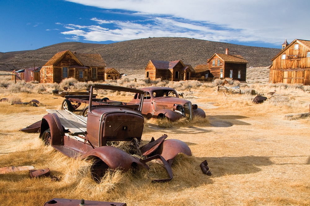
The remaining buildings at Bodie State Historic Park provide the backdrop for these abandoned autos.
Bodie State Historic Park
North of Mono Lake, the surviving 5 percent of Bodie’s original buildings capture the spirit and hardship of this wild gold town of the late 1800s. The leaning structures of darkened timber hint at once-bustling streets. Everywhere is subject matter, from the cobwebs on distorted window glass to the peeled, yellowed newsprint holding back the wind at the clapboard cracks. Leaky washtubs, cure-alls in a store window and the repeated names on infant gravestones, all tell a story. Reach the park 13 miles off U.S. 395 via State Route 270, the last 3 miles on rough dirt.
Manzanar
North of Lone Pine, this place given the charming Spanish name for “apple orchard,” represents a dark chapter in American history: internment camps. In 1942, some 10,000 Japanese-American men, women and children were stripped of their property and held here behind barbed wire without due process. Most were U.S. citizens. Somber, haunting, pensive, the site truly evokes mood.
The visitor center provides the backstory, with exhibits, a short film and nearby reconstructed barracks and mess hall. The 3.2-mile auto tour reveals remnants of camp orchards, gardens and foundations. Internees lived and worked within the confine. Erected to the 150 who died during incarceration, the gleaming white cemetery obelisk is a striking emblem against the Sierra backdrop. On our visit, a Japanese tour group had left folded paper cranes. Prayer flags were other tributes.
Alabama Hills
Viewed from Whitney Portal Road and dirt Movie Road (usually safe for dinghy vehicles, but check current conditions/road reconstruction), this rocky playground west of Lone Pine wears the name of a Confederate warship and triggered the imagination of Hollywood filmmakers in addition to Galen Rowell. From here, Rowell took his celebrated image of the Sierras, looking through Mobius Arch, also called Galen’s Arch. A loop trail visits the site; expect plenty of tripod-carrying company.
The hills’ rounded granite explores shades of buff, gold and pink, depending on lighting and lichen etching. The sharp-edged Eastern Sierras rise in contrast to the windows, blobs, bread loaves, pillars and imaginative layered forms. Phlox, paintbrush and cactus bloom lend seasonal accent. Where better as a photographer to practice Rowell’s “previsualization,” anticipating light and shadow and choosing the elements to invoke the desired impact or emotion?
Jeep roads and paths entangle the hills. Visitors can download the Movie Road Touring Brochure at www.blm.gov/style/medialib/blm/ca/pdf/bishop/suv.Par.46073.File.dat/movie_road_tour_brochure.pdf. In October, Lone Pine hosts a film festival, with guided caravan tours.
Creative Juices Still Flowing?
Yosemite, Mammoth Lakes, Devils Postpile, Sequoia and Kings Canyon and Death Valley await nearby.
For More Information
Bishop Chamber of Commerce
888-395-3952 | www.bishopvisitor.com
Bureau of Land Management, Bishop
760-872-5000
A turnout at the Old Marina Tufa Area offers RVers an expansive view of Mono Lake.
California State Parks
800-777-0369 | www.parks.ca.gov
Lone Pine Film Festival
Ticket office: 760-876-9103 | www.lonepinefilmfestival.org
Manzanar National Historic Site
760-878-2194, extension 3310 | www.nps.gov/manz/index.htm
Mountain Light Gallery
760-873-7700 | www.mountainlight.com
USFS, Inyo National Forest
760-873-2400 | www.fs.usda.gov/recmain/inyo/recreation