The First Leg – Dawson Creek, British Columbia, to Dawson City, Yukon Territory
![]()
For many people, Alaska is a dream destination that elicits many questions. Shall we cruise or fly? Will we see the real Alaska? How about traveling the historic Alaska  Highway in our own motorhome? I can tell you from experience that the answer is, absolutely yes! Nothing else compares.
My husband, Arjun, and I chose to make this epic 5,000-mile journey with an RV group tour organized by Adventure Caravans. On our trip we would learn about Alaska’s captivating history and ancient cultures while exploring towering mountains, massive glaciers, pristine fjords, unfettered wildlife and the marvel of Mother Nature’s artistry when left undisturbed.
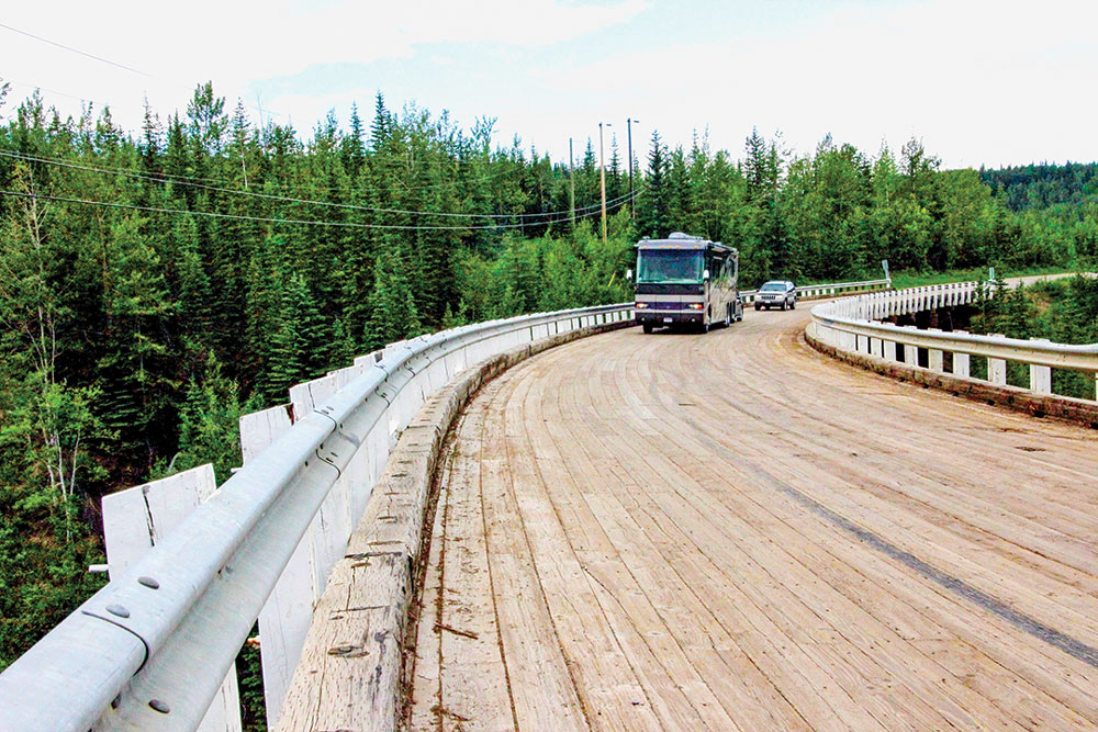
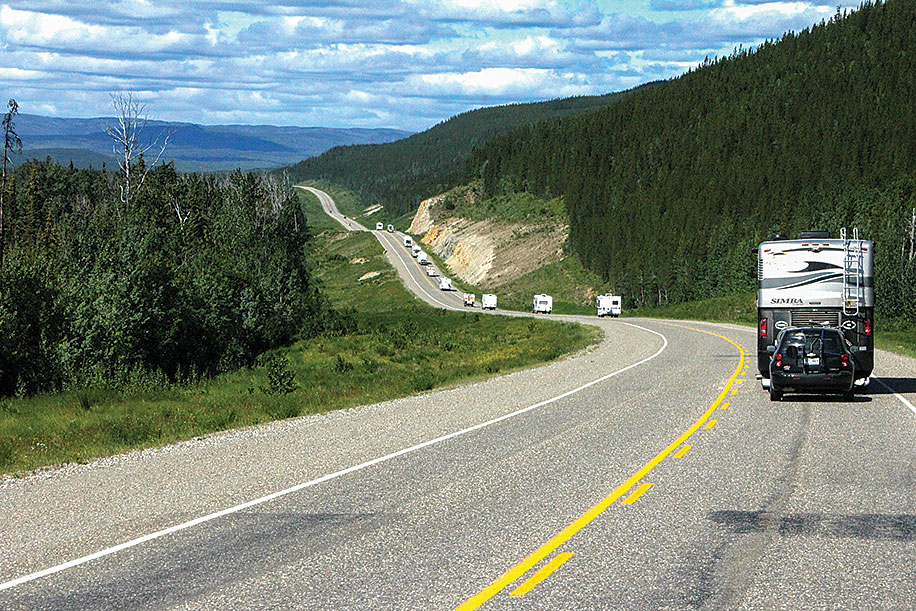
The Kiskatinaw River Bridge curves 9 degrees along its 543-foot length.
Alaska is larger than Texas, California and Montana combined. Everything here is super-sized, so think big! Mount McKinley – North America’s highest peak – dominates. More than 100,000 glaciers cover the land and in the fertile Palmer Valley, farmers routinely grow 80-pound cabbages and giant pumpkins during the long summer sunlight.
Before departing, we remember to pack our passports and drivers licenses; the current vaccination papers for our dog, Reggie; prescription medications; a spare tire for the motorhome and dinghy; extra gas cans (there can be up to 150 miles between fuel stations); and mosquito repellent. We’re ready to go!
Day 1: Dawson Creek
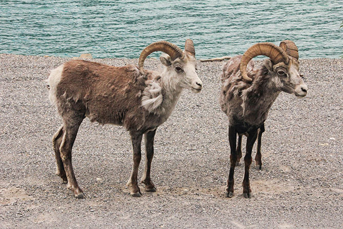
Stone sheep stand close to the highway near Muncho Lake Provincial Park.
Far up in northeast British Columbia, Canada, lies Dawson Creek, the official entrance to the Alaska Highway and the beginning of our journey. We meet up with the other RVers in our group – all have traveled thousands of miles to reach the rendezvous point.
We only have one day to explore Dawson Creek. This busy little town is loaded with history and everything’s within walking distance. So off we go!
Starting at the metal arch (cairn) located near the Northern Alaska Railway Park, a sign states: “You Are Now Entering
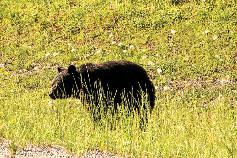
A black bear ambles along the side of the road in British Columbia.
the World Famous Alaska Highway.”
After Pearl Harbor in 1941, a highway connecting the Lower 48 with Alaska became vital. On March 8, 1942, 11,000 American troops and 7,000 pieces of equipment arrived in Dawson Creek. Joined by 16,000 Canadian workers, construction on the highway began. Clearing 1,500 torturous miles through mountains and forests in subzero temperatures and mud, 8 miles of road were laid everyday, seven days a week. The 1,390-mile project was completed in eight months, an amazing accomplishment.
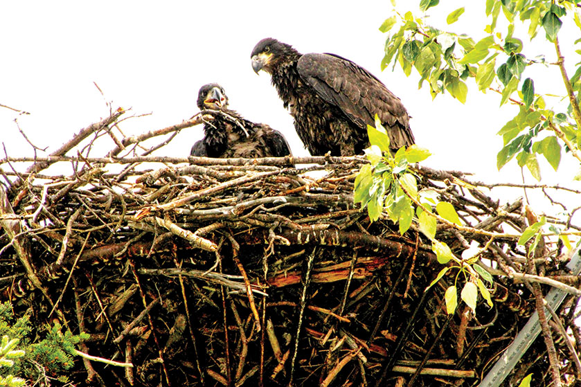
This enormous eagle’s nest was perched high atop a pole in Whitehorse, Yukon Territory.
On Nov. 20, 1942, the highway was officially opened during a ceremony at Mile 1061, known as Soldier’s Summit.
We stop in at the Dawson Creek visitors center and art gallery, located in a historic wooden grain elevator, and the Walter Wright Pioneer Village. Then we walk to the Mile 0 Monument, on 10th and 102nd Avenue, and visit the new Alaska Highway House Museum.
Later that afternoon, we return to the Northern Lights RV Park (www.nlrv.com) for our first Adventure Caravans orientation meeting and potluck dinner.
Day 2: Dawson Creek to Fort Nelson, British Columbia (281.2 miles)
The big day is here! We ready our Thor Challenger motorhome and do a final check. “The MILEPOST,” considered the bible of the North Country with details about traveling to Alaska, sits handily in the magazine rack. Odometer set to “0,” and we’re on our way.
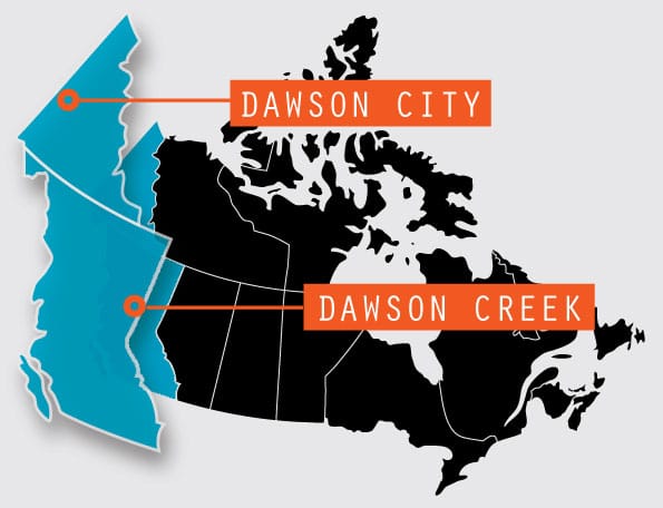
Similar, but Different: Dawson City, Yukon Territory, is often confused with Dawson Creek, British Columbia, which is Mile 0 and the beginning of the Alaska Highway.
Driving north, we look for historic milepost markers highlighting special points of interest, including lodges and roadhouses built during the 1940s, still used by travelers as mailing addresses and reference points.
At Mile 20 we take a diversion to Kiskatinaw Provincial Park, and the 534-foot historic Kiskatinaw River Bridge. This remarkable curved, wooden timber structure was constructed like this because of the sharp bend in the river, and is the only one remaining along the Alaska Highway. After crossing, we rejoin the Alaska Highway.
The road descends steeply to the Peace River Bridge near Taylor, British Columbia, and we continue to Fort St. John. After a huge natural oil and gas field was discovered in 1951, it became the Oil Capital of British Columbia and it was nicknamed the “Energetic City.”
At Fort St. John, Mile 72, is the Shepherd’s Inn and Husky fuel station, selling gas, diesel and propane. Their ad in “The MILEPOST” says “Fill up and get a free shower.” It’s a favorite stop for RVs and tour buses, but we keep going.
After a steep downgrade, we cross the Sikanni Chief River Bridge and at Mile 268, reach Spectra Energy, the foremost natural gas processing plant in North America. A large gas pipeline crosses the highway overhead.
At 4:30 p.m., Mile 281, we reach Fort Nelson and the Triple “G” Hideaway Campground & Family Restaurant (250-774-2340, www.triple
ghideaway.com), a full-service RV park open year-round.
Day 3: Fort Nelson to Liard Hot Springs Provincial Park, British Columbia (188.6 miles)
At 1,917 feet long, the Nisutlin Bay Bridge near Teslin is the longest water span on the Alaska Highway.
After a quick tour of the Fort Nelson Heritage Museum, where vintage autos, trucks and machinery used during the highway’s construction are displayed, we head north, then west toward Liard River, surrounded by splendid scenery and dense forests cloaked in fog. We climb steadily for the next couple of hundred miles to Steamboat Mountain (elevation 3,460 feet), a lonely, rugged, unexplored wilderness. Reaching Indian Head Mountain we pass “drunken forests” – a condition where thawing permafrost loosens the frozen soil, and the trees, unable to root deep in the ground, get pushed in all directions during high winds.
At Mile 392, we reach Summit Pass (elevation 4,250 feet), the highest point on the Alaska Highway. Snow-covered mountains are visible as we drive through a picturesque valley to the Toad River Lodge. An oasis in isolation, the lodge has a restaurant, post office, tire-repair shop, gas, diesel, propane and full-hookup RV camping. It’s also famous for a collection of more than 7,700 hats that deck the walls and ceilings.
Nearing Muncho Lake Provincial Park, we slow down for stone sheep standing stubbornly on the road. As we inch forward gradually, they reluctantly move aside.
Ahead is Folded Mountain. About 175 million years ago, the North American and Pacific plates collided, and the gigantic force raised and bent the land into amazing wave-like shapes.
At Mile 475, we reach Liard Hot Springs Provincial Park (www.env.gov.bc.ca/bcparks/explore/parkpgs/liard_rv_hs). Beautifully maintained and open year-round, it has large, wooded sites for dry camping only. This popular destination attracts visitors from all over the world, so book early.
A major construction camp was located here during the highway’s construction, and the hot springs became immensely popular with the troops.
After parking, we walk to the springs along the boardwalk, surrounded by a natural wetland and boreal forest plants. Tiny minnow-like fishes, “lake chubs,” dart among the plants feeding on algae. It’s amazing how they survive in this extremely warm water. At the hot springs, the temperatures range from 108 to 126 degrees Fahrenheit, and we settle into the Goldilocks zone, not too hot and not too cool.
Day 4: Liard River Provincial Park to Watson Lake, Yukon Territory (129 miles)
Soon after leaving, we spot a black bear ambling along the side of the road. Excited, we pull over, like the other RVers and motorists, hanging out the windows trying to capture an award-winning photo. As traffic starts to back up, impatient locals honk for us to move on. Sigh! We must leave.
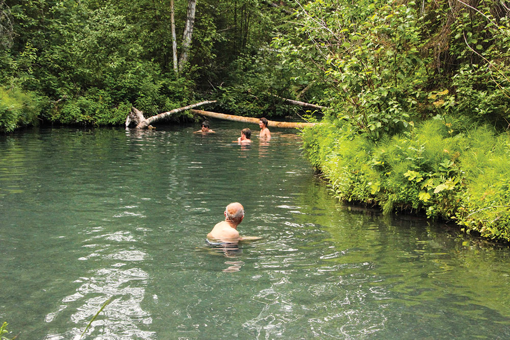
Liard Hot Springs Provincial Park has the second-largest hot spring in Canada.
In September 1942, two regiments, one from the north and one from the south, joined here, at Contact Creek, Mile 588, completing the southern segment of the Alaska Highway. Historic Contact Creek Lodge is open year-round and sells groceries, gas, diesel and propane. Minor repairs (including welding) are done here.
At Mile 627, we cross from British Columbia into the Yukon Territory, the first of seven crossings that bump in and out between the two. We drive into the town of Watson Lake at Mile 635 and pull into the Downtown RV Park (867-536-2646) at 3:30 p.m. Parking is tight and we must make sure our slideouts don’t hit our RV neighbor.
Watson Lake, famous for its Sign Post Forest, is located at the junction of the Alaska and Robert Campbell highways.
In 1942, homesick Private Carl K. Lindley, working on the highway, put up a sign pointing the direction to his hometown in Danville, Illinois. Others followed and it soon grew into this remarkable place. It’s a tradition to leave behind “a sign,” so we remove the front license plate of our dinghy vehicle and nail it to a post. It’s like looking for prime real estate to find a vacant spot. If you come, bring a sign, a hammer and some nails.
Day 5: Watson Lake to Whitehorse, Yukon Territory (265.7 miles)
Heading toward Whitehorse, mountains, valleys, lakes and wildflowers grow profusely along the highway, including the bright purple “fireweeds.” The locals say, “When the fireweeds top out, it’s time to get the long johns out.”
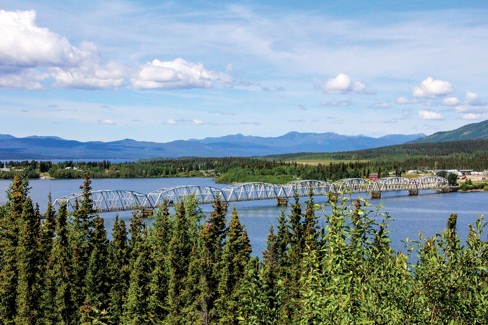
At Teslin, we cross the 1,917-foot Nisutlin Bay Bridge, the longest water span on the Alaska Highway. After crossing the 1,466-foot Teslin River Bridge, third-longest bridge on the Alaska Highway, at Mile 911, we enter Whitehorse and pull into the Pioneer RV Park & Campground (867-668-5944, www.pioneer-rv-park.com), our home for the next three nights. It has partially wooded sites, full hookups and sells gas, diesel and propane. Rig washing is allowed and there’s also a dog-washing facility.
Whitehorse, a major hub for travelers, is well served with department stores, restaurants, and RV parts and repair outlets.
Nicknamed the “Wilderness City,” Whitehorse, located on the banks of the mighty Yukon River, is named for the treacherous waters of Miles Canyon Rapids, which resemble the flowing manes of white horses.
After gold was discovered in the Klondike and Yukon in 1898, Whitehorse was swamped with prospectors heading north to Dawson City (our next destination). Rumors that gold nuggets littered the creeks and roads of Dawson City started a crazy stampede, but they first had to navigate the dangerous waters of Miles Canyon, where many boats were wrecked and lives lost in the frantic rush.
Day 6: Whitehorse, Yukon Territory
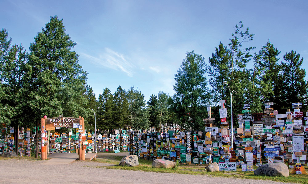
A must-see: The famous Sign Post Forest in Watson Lake, Yukon Territory, at Mile 635.
We arrive for a guided tour of the historic SS Klondike. Built by the British Yukon Navigation Company in 1937, it plied the Yukon River between Whitehorse and Dawson City as a freight and passenger boat, with elegant interiors for first-class passengers. The boat was retired in 1955; in 1966 it was “elevated” to its present location on dry land, and designated a National Historic Site.
Next, we tour the Yukon Brewing Company to sample some of its specialty beers for a fun-filled, lip-smacking experience.
At 8:30 p.m., we attend the entertaining Frantic Follies vaudeville revue in the Westmark Whitehorse Hotel. Reliving the early 1900s, this not-to-be-missed high-stepping review and lively can-can dancing show has entertained viewers for almost 50 years.
Day 7: Whitehorse, Yukon Territory
As we leave the RV park for a day of sightseeing, we spot an enormous eagle’s nest high on a pole and two young eagles flapping their wings, getting ready for flight.
We head to the Yukon Transportation Museum to see the world’s largest, one-of-a-kind weather vane. Completing its final flight in November 1970, this DC-3 was donated to the Yukon Flying Club, raised and flawlessly balanced on a pedestal built by master welder Al Jacobs. We watch fascinated as it slowly revolves on its mount, pointing into the wind, just as it did decades ago, ready for takeoff. Incredibly, it only takes a 5-knot wind to turn it.
At the Yukon Beringia Interpretive Centre nearby, we tour exhibits and watch a film about the prehistoric era of this land. During the last Ice Age, between 18,000 and 11,000 years ago, sea levels were lower, and a vast land bridge called Beringia connected Asia and North America. This became the migration route for woolly mammoth, mastodon, brown bear, moose, and musk ox, and early human hunters followed, becoming the first inhabitants of North America. After the ice melted, this land became submerged, and is now the Bering Sea.
Returning to Pioneer RV Park, we prepare for the long drive tomorrow.
Day 8: Whitehorse to Dawson City, Yukon Territory (335 miles)
After driving north for 15 miles, we leave the Alaska Highway (only temporarily) and take the Klondike Highway (Yukon Highway 2) toward Dawson City (not to be confused with Dawson Creek, British Columbia, at Mile 0 – the start of the Alaska Highway). It’s a six-hour drive along the same route used by gold prospectors during the frantic rush to reach Dawson City.
Our RV group caravanning north on the Klondike Highway to Dawson City through desolate mountains, high ridges and forests.
Heading north (as did the prospectors) across a mostly uninhabited plateau surrounded by desolate mountains, high ridges, forests and lakes, one senses the wilderness and aloneness here.
At Carmacks, we’re 78 miles from Dawson City. George Carmack’s isolated trading post went bankrupt in 1885 so he moved his family to another isolated area, now Dawson City. That summer he struck it rich, discovering huge quantities of gold in Rabbit Creek, which he renamed Bonanza Creek. Word of his discovery ignited the gold rush.
After crossing the Yukon River Bridge, we pull into a large rest area with an expansive view of the Five Fingers Rapids rocky outcrops in the river. Overloaded boats traveling between Whitehorse and Dawson City in 1898 frequently struck these rocks and sank. Many lives were lost.
On to the Tintina Trench – a major fault that ripped apart the earth’s crust, stretching more than 600 miles from southeastern Yukon west to near Fairbanks. One side of the fault has shifted diagonally about 280 miles in the last 200 million years. The rocks and land of Whitehorse and Dawson City, once adjacent, are now about 300 miles apart.
At 4 p.m., we arrive at Gold Rush Campground (866-330-5006, www.goldrushcampground.com) and settle in for the night. The sites are short, unpaved and very narrow.
Day 9: Dawson City, Yukon Territory
Strategically situated at the confluence of the Yukon and Klondike rivers, Dawson City (once the capital of the Yukon), is a well-preserved gold rush town, and National Historic Site. It still looks and feels like a living, breathing 1870s town.
Despite its remote wilderness location, the city is a vibrant cultural and tourist center. The gold fever that gripped North America a century ago made this charismatic town the largest metropolis north of Seattle, Washington. Brightly painted wood buildings line the streets, hurriedly constructed when the gold rush brought thousands into the city.
At the visitors center, Marieke Hiensch, our costumed guide, recalls the vibrant life 100 years ago. Businesses sprang up to meet people’s needs, and Ruby Scott – one of the city’s colorful characters, originally from Paris – opened a brothel “to please lonely men.”
The Post Office was the daily gathering place for residents. Hiensch tells us about postal employee Percy DeWolf, who transported mail from Dawson City to Eagle, Alaska, 150 miles away. In summer, he used a boat-and-horse team, but during the brutally cold winters, he led his sled dogs along the banks of the treacherous frozen Yukon River. Thirty-five years, and he never missed a day.
The Percy DeWolf sled-dog race, held every winter, honors this Iron Man of the North, attracting world-class mushers from the Yukon Quest and Iditarod, a qualifying race for both.
“How many cities boast about their local dump?” asks Hiensch. “Dawson City does!” Its isolation created a tradition for residents to leave unwanted possessions here for others to take home. “Cave Man Bill” proudly hauled a grandmother clock back to his cave. Kept awake by the ding-dong every hour, he returned it the next day. “Too noisy,” he declared.
There’s history on every street: Diamond Tooth Gertie’s Gambling Hall, Klondike Kate’s restaurant, the Midnight Sun Hotel and Flora Dora Hotel, all established in the late 1800s and early 1900s, tell the city’s past.
The once-busy Dawson City Daily News’ old printing presses stand silent.
At sundown, the city springs alive, bringing back the long-gone feverish gold rush days.