![]()
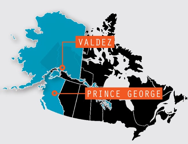
The Final Leg – Valdez, Alaska, to Prince George, British Columbia
We’ve reached the last part of our great Alaskan adventure, but we still have 12 more days and roughly 1,800 miles left to explore, including a trip on the White Pass & Yukon  Route Railroad and a catamaran cruise through the storied Inside Passage.
Day 35: Valdez to Tok (254.6 miles)
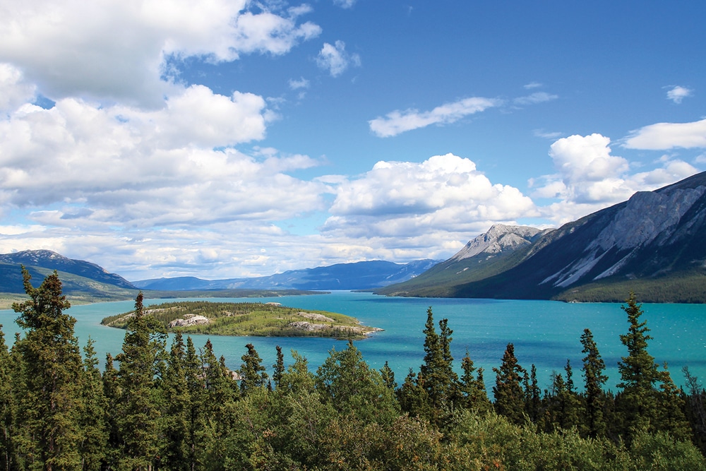
Canada’s Tagish Lake has two arms, Taku Arm in the east and Windy Arm in the west. The Klondike Highway runs along Windy Arm, south of Carcross, Yukon Territory.
Leaving Bear Paw RV Park in Valdez, our destination is Tok RV Village. The weather is 51 degrees, and for the next 20 miles, moisture-laden bushes droop heavy with fog, and mist surrounds the hills. The dew-laden roadside grass glows silvery in the morning sun as we head north on the Richardson Highway.
Low clouds shroud the mountaintops of Keystone Canyon, and hanging glaciers slip into the silent valley below. Waters gently cascade down Bridal Veil and Horsetail falls just off the road. We drive cautiously along the slippery mountain highway. As we begin the 7-plus-mile ascent through legendary Thompson Pass, trucks on the road groan and struggle to make the climb.
Thirty-three miles out of Valdez, the Worthington Glacier fills the 5,774-acre valley. The light is different now as its icy white cloak glows in the soft sun. We were here four days ago on our way to Valdez, but it’s so irresistible that we stop again to take it all in.
The sun breaks through the clouds and casts a gentle blush across the valley while the majestic Wrangell Mountains glisten in the distance. We see small lakes scattered throughout the area, an eagle sunning itself high on a tree and a moose feeding on lush green reeds in a roadside pond.
Turning right at Tok Highway, we pass the historic Gakona Lodge and Trading Post at the confluence of the Gakona and Copper rivers. Crossing the Chistochina River, gorgeous views accompany us all the way to the junction of the Glenn Highway. At mile 254, we turn onto Alaska Highway 2 and then into Tok RV Village (907-883-5877, www.tokrv.net).
Day 36: Tok, Alaska, to Destruction Bay, Yukon Territory (224.5 miles)
Back on Alaska Highway 2 south, the road is full of washboards, frost heaves and construction, which back up traffic and slow us to a crawl. Crossing the Tanana River bridge, we arrive at the Tetlin National Wildlife Refuge at mile 82.1. This 730,000-acre bird migration corridor is known as the Tetlin Passage, where more than 180 bird species and 44 mammals raise their young.
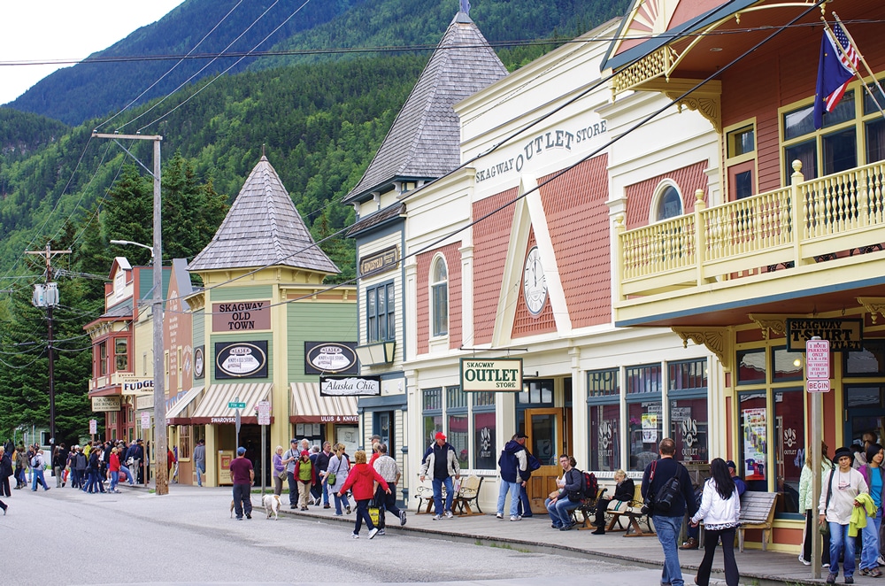
Broadway, one of Skagway’s main streets, is home to many buildings built between 1897 and 1900.
At the U.S. Customs and Border Protection station Port Alcan, we’re back in the Yukon Territory. Small, busy Beaver Creek is a good place to stop, refuel and satisfy your hunger. Buckshot Betty’s has a restaurant/store, fuel, an ATM and post office.
Now 20 miles southeast of the border, we’re 113 miles from Tok and 184 miles from Haines Junction. Construction crews working from opposite directions connected the Alaska Highway here at Beaver Creek in 1942.
Except for occasional frost heaves, it’s a scenic, relaxing drive. At mile 180.5 there’s a dramatic view of Canada’s six highest peaks, all more than 15,000 feet tall. We stop at the Kluane Museum of Natural History at Burwash Landing. Small and unimpressive on the outside, it’s amazing inside. Rated No. 1 in the Yukon, its remarkable wildlife exhibits are displayed as if in their natural habitat.
At mile 224.5 we reach Destruction Bay RV Lodge (867-841-5332) for the night. It has spacious sites with electricity and water, but no sewer hookups.
Destruction Bay, on the shores of Kluane Lake at Alaska Highway mile 1,083, was a truck relay station during the highway’s construction before a devastating storm wreaked havoc here, giving it its name.
Lodge owner Loren Maluorno has a special evening planned for our RV group: a sumptuous dinner with roast beef, potato salad and berry pie. Yum! After dinner, Maluorno narrates fascinating Yukon folklore and tells us about life in this remote area.
Day 37: Destruction Bay, Yukon Territory, to Skagway, Alaska (269.5 miles)
Continuing along the Alaska Highway, we pass Soldier Summit, site of the 1942 opening of the Alaska Highway. From Haines Junction we continue on to Whitehorse, then turn onto Klondike Highway 2 heading toward Skagway.
Going With a Group: If you’d like to travel to Alaska with other RVers, two popular tour companies are Adventure Caravans (844-872-7897, www.adventurecar
avans.com) and Fantasy RV Tours (800-952-8496,www.fantasyrvtours.com).
On to the village Carcross, originally named Caribou Crossing. Just north of town is said to be the world’s smallest desert, and it’s a magnet for travelers. We wonder how a desert could have formed here. These sand dunes are remnants of the last ice age, when a large lake dried up, leaving behind this rare, geological feature.
Driving south we stop for pictures at the Bove Island lookout in Tagish Lake, with expansive views of Windy Arm. Approaching the border at mile 249.9, there’s a long line ahead. This is supposedly the busiest of all U.S./Canada border-crossing stations. All vehicles must pass through a large metal arch scanner, and the space is so tight, it’s disconcerting.
At White Pass Summit, the time zone changes and we set our clocks back one hour. A steep downgrade takes us from 3,292 feet to sea level in just 11½ miles along a narrow, single-lane road hedged in by mountains. Congested with buses, RVs, bikers and hikers all going to Skagway, extreme caution is required when driving here.
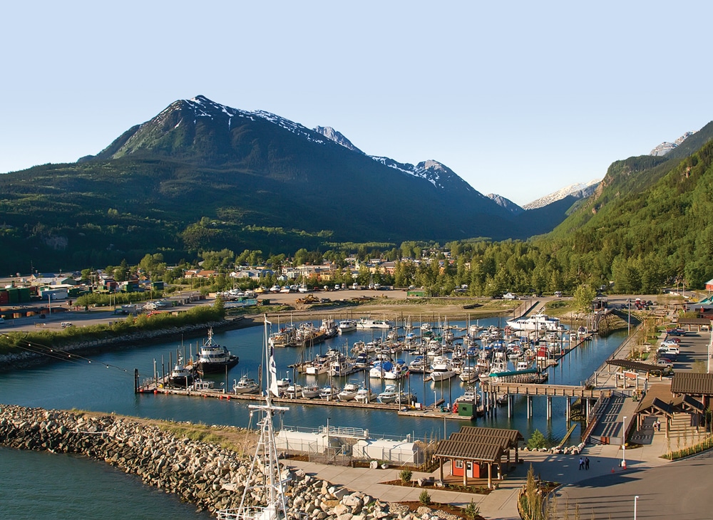
Crossing the Skagway River gorge and Captain William Moore Bridge, we enter Skagway and check in at the well-laid-out, full-service Garden City RV Park (907-983-2378).
Day 38: Skagway, Alaska
Skagway, nestled in a fjord at the northern end of Alaska’s Inside Passage, became a major corridor to the Yukon when gold rush fever swept North America like a tidal wave in 1898. Boats off-loaded thousands of prospectors, and Skagway was transformed into a tent city flooded with gold seekers heading north to Dyea. From here they hiked the perilous Chilkoot Trail, called “the meanest 33 miles in history” to Whitehorse. Waiting boats took them up the hazardous, rock-strewn rapids of the Yukon River. Many lives were lost when boats floundered and sank as they headed to Dawson City, where it was rumored the area was littered with gold. It’s estimated that of the 40,000 or so who undertook this treacherous journey, only 4,000 found gold.
Skagway is one of the most interesting and popular towns to visit in Alaska’s Inside Passage.
Today, about 2,000 hikers annually retrace history along the Chilkoot Trail, now a historic landmark. The construction of the White Pass & Yukon Route Railway (WP&YR) in 1900 made the Chilkoot Trail obsolete.
Skagway was a hotbed for lawlessness and scoundrels, the most notorious of which was “Soapy Smith,” a con man who sold wrapped soap bars containing $5, $10, and $100 bills to excited bystanders. Soapy’s own cronies, mingling with the crowd, always found the money. Soapy became entrenched in Skagway’s politics. At Jeff Smith’s Parlor, under his watchful eye, many fraudulent decisions favoring him were made. Eventually, a vigilante committee was formed to confront him. During a meeting at the wharf, Soapy arrived unexpectedly. Frank Reid, the city’s surveyor, confronted him, and a shootout ensued, leaving Soapy dead and Reid fatally wounded.
Reid and Smith were buried at the Gold Rush Cemetery about 2 miles north of town. An impressive memorial marks Reid’s grave, but Soapy’s, so insignificant, is hard to find. A nearby waterfall was named after Reid, but Soapy became the town’s legend.
Between 2nd and 3rd avenue, the Arctic Brotherhood Hall was built in 1898. Thousands of pieces of local driftwood cover its facade, making it the most photographed building in Alaska. We see the Trail of ’98 Museum inside.
Also worth visiting is the Skagway Museum and Archive, located in the old McCabe College building and the WP&YR 1898 Train Depot.
This evening our caravan group gathers at Eagles Hall, on 6th and Broadway, for Monte Carlo Night, and then head next door to the adjoining theater for the “Days of ’98.” This hugely entertaining vaudeville show is presented as a hilarious skit recalling the wild gold rush days, and includes can-can dancers and ragtime music.
Day 39: Skagway, Alaska (Juneau trip)
Today we ride a catamaran to Juneau, the only state capital in the U.S. without road access. At 7:25 a.m., Captain Glen Jacobsen, along with his deckhand, daughter Anna, welcomes us aboard the Fjordland. We’re served breakfast and coffee as we make our way through the early morning mist of the Lynn Canal. Inappropriately called a “canal,” this massive, 2,000-foot-deep gorge is part of the storied Inside Passage. It’s the longest, deepest glacial fjord in North America, and part of the Marine Highway System connecting Juneau, Haines and Skagway.
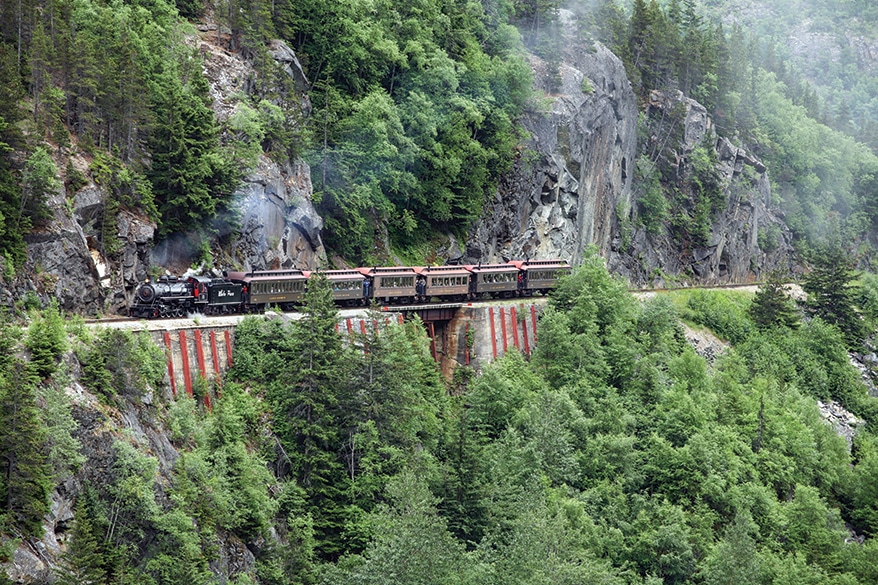
The WP&YR narrow-gauge railroad was built during the Klondike Gold Rush of 1898.
Humpback whales inhabit these deep waters. Suddenly Capt. Jacobsen calls out “whales sighted starboard,” and everyone rushes outside, cameras clicking. Three or four humpbacks put on an incredible show, blowing, diving and frolicking.
Once we reach Juneau it’s raining, and a bus takes us into downtown. We browse some gift shops and warm up with hot chocolate at the Heritage Café on South Franklin Street, then meet up with many of our caravan friends at the Red Dog Saloon. Several large cruise ships are in the harbor, and the restaurant/bar with its popular Wild West theme is packed.
After lunch, the bus takes us past the Alaska State Capitol, the governor’s mansion and other attractions on our way to Mendenhall Glacier. A trail from the glacier’s visitor center leads to outstanding views. The massive glacier is about 12 miles long and 1½ miles wide, rising 100 feet above the water, with ice depths about 2,000 feet in some areas. We take photos of this natural marvel and then head back to town for our return trip to Skagway.
Heading back on the boat, we pass an area of treacherous rocks and three lighthouses. In February 1898, the story goes, the Clara Nevada, with 40 passengers and lots of gold, hit rocks during a violent storm and sank. Original reports indicated four survivors, but no lifeboat or gold was found. Later, rumors surfaced that the captain and some of his crew were seen in various towns having a good time.
Day 40: Skagway, Alaska (train trip)
Today we ride the famous WP&YR. (Remember to take your passport since the train enters Canada and re-enters the U.S.) Construction on the WP&YR began in 1898. The railroad, including a steel-cantilever bridge, was completed in two years. Climbing nearly 3,000 feet in 20 miles and negotiating extreme, rugged topography, numerous bridges, sharp bends and two tunnels dug through the mountains and viaducts across deep gorges, this amazing engineering feat was designated an International Historic Civil Engineering Landmark, and awarded equal status as the Panama Canal, Eiffel Tower and Statue of Liberty.
Boarding one of the refurbished vintage passenger coaches, we settle into our seats for the 3½-hour, 40-mile round trip. Leaving town, we pass Gold Rush Cemetery and a black cross marking a tragic accident, when a massive 100-ton granite rock plunged down the hill crushing two workers.
The landscape changes rapidly as we negotiate sharp cliffs, bends and bridges. Surrounded by mountains and cascading waterfalls, we cross deep ravines and salmon-filled rivers. The original bridge, built in 1901, now unused, is pointed out to us. At Inspiration Point there’s an awesome view of Lynn Canal and the Chilkat Range.
Then, without warning, we plunge into two long, pitch-dark tunnels. Blinded as we re-enter daylight again, there’s much amusement among our group, trying to figure out “who kissed who.” Reaching White Pass, the international U.S./Canadian border, flags of both countries fly. The locomotives are unhooked, and moved to the other end for our return to Skagway.
Once back in Skagway, we visit the famed Red Onion Saloon. Stepping inside this once-boisterous tavern, its Wild West mood is infectious. Retaining much of its bygone theme, the original old bar with its loud atmosphere is a popular hangout. Waitresses dressed in period costumes, and dollar bills tucked into their bras, busily serve customers. On the enormously popular “brothel tour,” buxom ladies in typical late 1800s-style dresses escort curious visitors upstairs. It costs $5 for 15 minutes, “just like the good old days,” says the “madam.”
Day 41: Skagway, Alaska, to Northern Beaver Post, Yukon Territory (308.1 miles)
Leaving Skagway, we pass through White Pass Summit U.S. customs station and turn our clocks ahead one hour. Retracing our route along Tagish Lake and Carcross, we turn right onto Route 8 toward Atlin/Tagish, cross the Tagish Bridge and turn right onto Alaska Highway 1 toward Teslin.
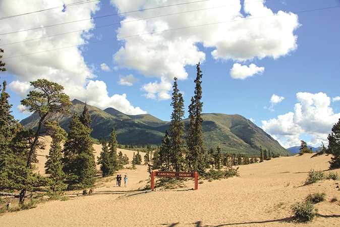
The sand dunes north of Carcross are remnants from the last ice age.
The Teslin Tlingit Heritage Centre on Teslin Lake has many interesting exhibits of Tlingit history and culture. An impressive and colorful row of totem poles lines the main entrance. After briefly visiting the nearby George Johnston Museum, we resume our journey through conifer forests.
We cross Nisutlin Bay Bridge and our pleasant drive continues through gently undulating terrain, crossing the Continental Divide, then passing Rancheria Falls at mile 234.3. Just beyond Big Creek Bridge, we look for the Cassiar Highway 37 south sign and at mile 308 check in at Baby Nugget RV Park (867-536-2307, www.nuggetcity.com/rvpark.html). The park has water, electric and cable, and a dump station.
Day 42: Northern Beaver Post, Yukon Territory, to Dease Lake, British Columbia (147.4 miles)
Leaving Baby Nugget RV Park, we take Cassiar Highway 37 toward the British Columbia/Yukon Territory border.
We stop at Cassiar Mountain Jade Store at mile 76.2. Jade is brought over from the Princess Jade Mine, about 82 miles east. It’s one of the largest jade claims in the world. We watch precision carving of vases, jewelry, memento boxes, chess sets and more.
Our drive continues, surrounded by rolling hills and pristine lakes. Mount Edziza, part of an active 7½ million-year-old volcanic complex, is located within a provincial park where obsidian tools and weapons made by the Tahltan and Iskut people have been excavated.
Farther on, we drive past a vast forested area of several thousand acres, where a lightning strike in 2010 ignited a devastating fire, closing the Cassiar Highway for several days. This natural phenomenon lets nature rejuvenate the forests
At mile 147.4 we turn left into Dease Lake RV Park (250-771-4666).
Day 43: Dease Lake, British Columbia, to Hyder, Alaska (242 miles)
Back on Cassiar Highway, we reach Gnat Pass Summit (elevation 4,072 feet), and encounter many sharp curves along this mountainous terrain. At mile 55.2, we reach a large pullout overlooking Tatogga Lake. This beautiful scene is a must for great photos.
Bell II Crossing, mile 148.3, is a convenient place for fuel and shopping. Continuing along Route 37A south to Meziadin Junction and heading toward Stewart and Hyder, we’re surrounded by majestic mountains. The dramatic scenery makes for an exceptionally picturesque drive.
At mile 221 we reach Bear Glacier. Captivated, we stop to admire the icy blue glacier. We must leave now, but we’ll be back tomorrow. After passing the “Welcome to Stewart” sign, we turn into Bear River RV Park (250-636-9205, www.bearriverrvpark.com).
The Portland Canal, a narrow 90-mile-long saltwater fjord, separates Hyder, Alaska, and Stewart, Canada. The main attraction here is Fish Creek, just north of Hyder. Located in the heart of the Tongass National Forest, Fish Creek Wildlife Observation Site attracts brown (grizzly) and black bears that come here to fish for returning chum and pink salmon. This recreation area along the Salmon River is open mid-July through early September with an admission charge. Operated by the U.S. Forest Service, rangers are present to ensure the safety of visitors.
We drive to Fish Creek along the heavily wooded Salmon Glacier Road, where bears frequently wander, to the observation area. We enter a long viewing platform that runs along Fish Creek and spot a bear ambling along the stream. As dusk approaches, we return to the RV park.
Day 44: Stewart, British Columbia, and Hyder, Alaska
The quaint town of Hyder, Alaska (population about 100), is called the “friendliest ghost town in Alaska” and recalls frontier days. The small post office, a few businesses and restaurants service the needs of the residents.
Feeling brave? Stop at the Sealaska Inn and Camp Run-A-Muck to get “hyderized” with a shot of its famous 190-proof alcohol drink, also fittingly called the “snake bite.” It’s pretty potent stuff we’re told. Remember, if you go to Hyder or Fish Creek, both in the U.S., you must show your passport when returning to Stewart, Canada. Both observe Pacific Time.
Hearing there’s a lot of bear activity today, we head to Fish Creek. It’s misty with a light drizzle, and covering our cameras with plastic bags, we find excellent spots on the viewing platform.
Around mid-morning, we return to Bear Glacier on Highway 37, north of Stewart. From a viewpoint along the road, we stop for one of the most amazing sights we’ve seen: a huge, luminous blue-and-white ice bridge formed at the toe of the glacier. In the silence we can hear the melting water rush under the bridge into Strohn Lake.
Returning to our campsite we prepare for tomorrow’s drive.
Day 45: Stewart, British Columbia, to Smithers, British Columbia (204.6 miles)
Today, typical mountain weather rules with intermittent sun, clouds and fog. Heading back north on Highway 37, we’re treated to a close encounter – black bears ambling along the roadside. Paying no attention to us, they wander off into the nearby forest.
Passing Meziadin Lake Provincial Park, a popular site for boating, camping and fishing, we keep going. An interesting detour and historical side trip at mile 134 is St. Paul’s Anglican Church, with its original 1893 bell tower and several totem poles. We continue, and look out for Yellowhead Highway 16 heading to Smithers.
At Moricetown, mile 182.3, we photograph nets set up by fishermen. Once inhabited by the Bulkley Valley Indians, it was renamed after the pioneer missionary, Father Morice. Salmon swimming upstream are caught with basketry traps, dip-nets and harpoons, then smoked at the native hatchery.
At Smithers, mile 204.6, we take a right toward Smithers Par 3 and RV campground (250-847-3229, www.smitherspar3andrv.com/the-rv-park).
Day 46: Smithers, British Columbia, to Prince George, British Columbia (232 miles)
Today is the final leg of our journey. Back on Yellowhead Highway 16, we drive through Houston, Topley, Burns Lake and Frazer Lake. Reaching a steep downhill grade at mile 214, we see a “Welcome to Prince George” sign. We find it somewhat complicated getting through Prince George to the Southpark RV Park (250-963-7577). Spacious, wooded, and well-maintained, we settle into our full-service site.
Our farewell dinner starts at 4:30 p.m. at Carmel Restaurant. After a huge buffet, we receive a gift bag of memories from Adventure Caravans.
Day 47: Prince George, British Columbia
After a farewell breakfast, hugs and goodbyes, our friends hitch up and drive away one by one. Waving to each other, we feel sad. It’s not an understatement to say this was a once-in-a-lifetime journey. Credit for our extraordinary, trouble-free experience goes to the planning and support of wagon masters Ken and Carole Adams and tail gunners Bill and Carol Hamilton.
Needing to get some work done on our motorhome before the long trip back home to Wisconsin, we stay another day in Prince George. We drop off our coach at a service center for a front-end alignment and replacement of leaking rear-axle seals (the result of the rough roads). We have a few hours available so we unhook our dinghy and explore the city.
At the Central BC Railway and Forestry Museum, we explore and climb into some old locomotives, fire engines and rail cars, and take a ride on the Cottonwood Minitrain. We then head to the Two Rivers Gallery, which focuses on contemporary Canadian art. Picking up our motorhome, we return to the RV park and prepare for our trip home.
This trip was indeed an exceptional experience. The all-embracing wilderness and serenely beautiful contact with nature in all its majesty made for the motorhome journey of a lifetime.