
From Great Smoky Mountains National Park to the Blue Ridge Parkway, a North Carolina road trip into the heart of Appalachia reveals a land of waterfalls, wildflowers and other over-the-top wonders
Great Smoky Mountains National Park and the Blue Ridge Parkway are two of America’s favorite destinations within the National Park System, and there’s no wonder why. They are gorgeous, they’re filled with things to see and do, and they’re not too far from the major cities on the Eastern Seaboard.
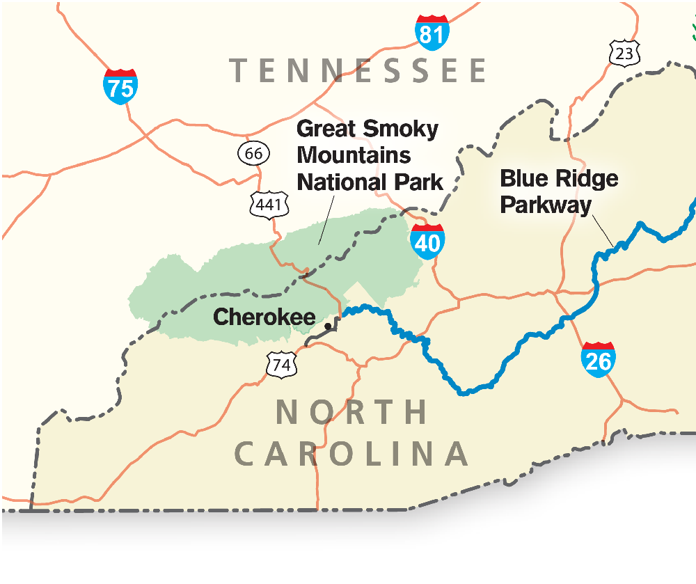
 Both are located in the Blue Ridge Mountains, a range in the Appalachians, but each is very different. Great Smoky Mountains National Park is enormous. It spans two states, North Carolina and Tennessee, and has four visitor centers inside the park. Just outside the park’s boundaries are four more information centers. The Blue Ridge Parkway is a narrow 469-mile-long ribbon of road that connects Great Smoky Mountains National Park to Shenandoah National Park in Virginia, and the locations of its many sightseeing highlights are designated by mileposts.
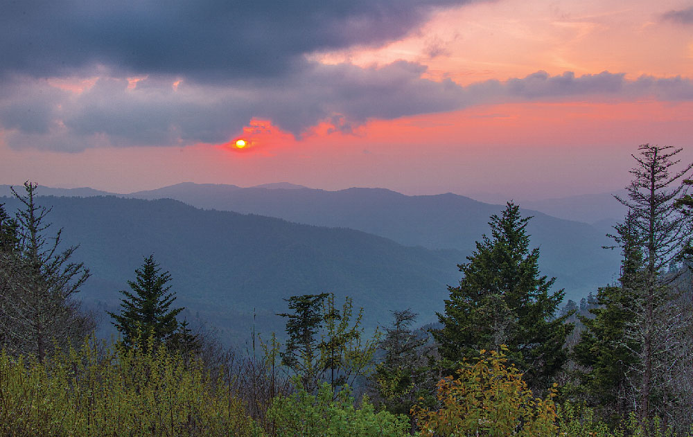
A classic Smokies sunset lights up the sky on the descent from Clingmans Dome, the highest point in Great Smoky Mountains National Park.
When we took our 36-foot HitchHiker fifth-wheel trailer on a road trip to this area recently, we opted to use the small town of Cherokee, North Carolina, as our home base. Cherokee is perched at the confluence of Newfound Gap Road, which traverses Great Smoky Mountains National Park, and the southern terminus of the Blue Ridge Parkway. It is an ideal spot to explore both of them.
Cherokee itself is quite touristy, but the slightly cheesy atmosphere is still fun. Members of the Cherokee tribe stand on the street corners in full-feathered-and-beaded regalia, complete with fringe and moccasins, eager to talk with visitors and invite them into their souvenir shops.
As we strolled through town, we came across a group of Native American street performers doing an impromptu dance. We had no idea whether the moves and music were authentic or just for tourists, but we laughed and clapped alongside a dozen other visitors and enjoyed the show immensely. Three dancers demonstrated various footwork and arm gestures, including an evocative Eagle Dance and theatrical Warrior Dance.
GREAT SMOKY MOUNTAINS
Leaving the beaded jewelry and trinkets behind, we quickly found the natural wonders of the Smoky Mountains just steps from town on the Oconaluftee River Trail. An easy and delightful hiking and biking trail wanders beside the namesake river for a mile and a half between the Cherokee Welcome Center in town and the Oconaluftee Visitor Center in the national park. The pungent smell of leaves on the trail tickled our noses, and our eyes grew wide when we turned a corner and spotted a bull elk and his harem of females standing in the river just a few feet away, leisurely taking a morning drink.
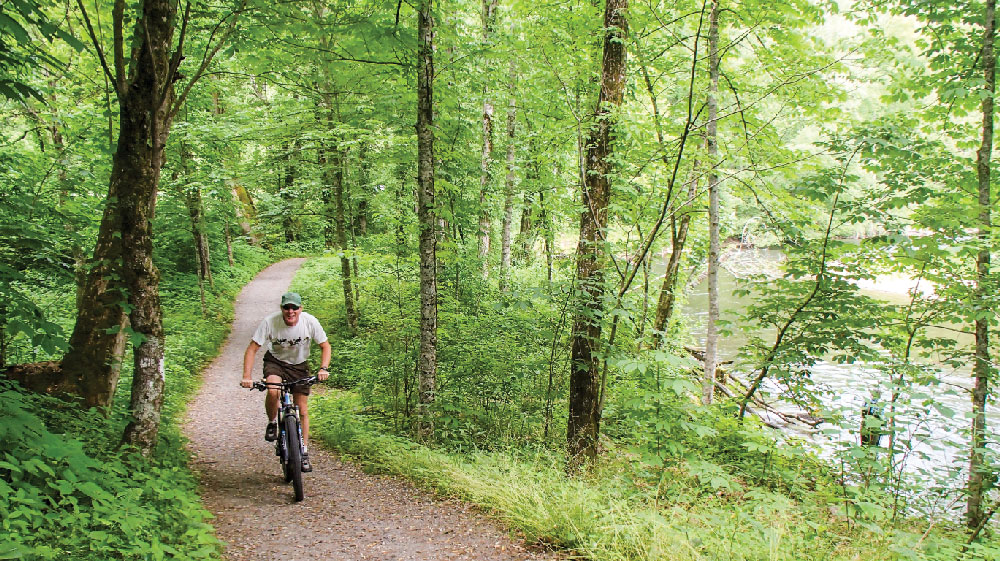
The Oconaluftee River Trail crosses the junction of Newfound Gap Road in Great Smoky Mountains National Park.
Elk were reintroduced to the Smokies in 2001 and 2002, and the herd has thrived since then, with their numbers now topping 150. Many wear radio collars so they can be tracked, and during a second biking excursion on this same trail, we came upon a female elk wearing one. She stood stock still, turning her head slowly from side to side to look at us first with one eye and then with the other.
Over the next few days, we learned that elk sightings are commonplace in the fields around the Oconaluftee Visitor Center. Lots of tourists congregate there to watch the herd and also to wander through the historic cabins of the Mountain Farm Museum next door. These cabins, built more than a century ago, were gathered from throughout the Smoky Mountains in the 1950s and moved to this site. They offer a step back in time, showing just how dramatically life has changed in a few short generations.
A half-mile farther into the park on Newfound Gap Road, we encountered more 19th-century history at Mingus Mill, a historic gristmill dating to 1886. This mill was unusual because it was powered by water flowing along a raised millrace to a cast-iron turbine, rather than to a more conventional paddle wheel. The turbine generated the power to crush grain on a grindstone, providing cornmeal and wheat flour for the whole community. Samples of those grains are sold at the mill today.
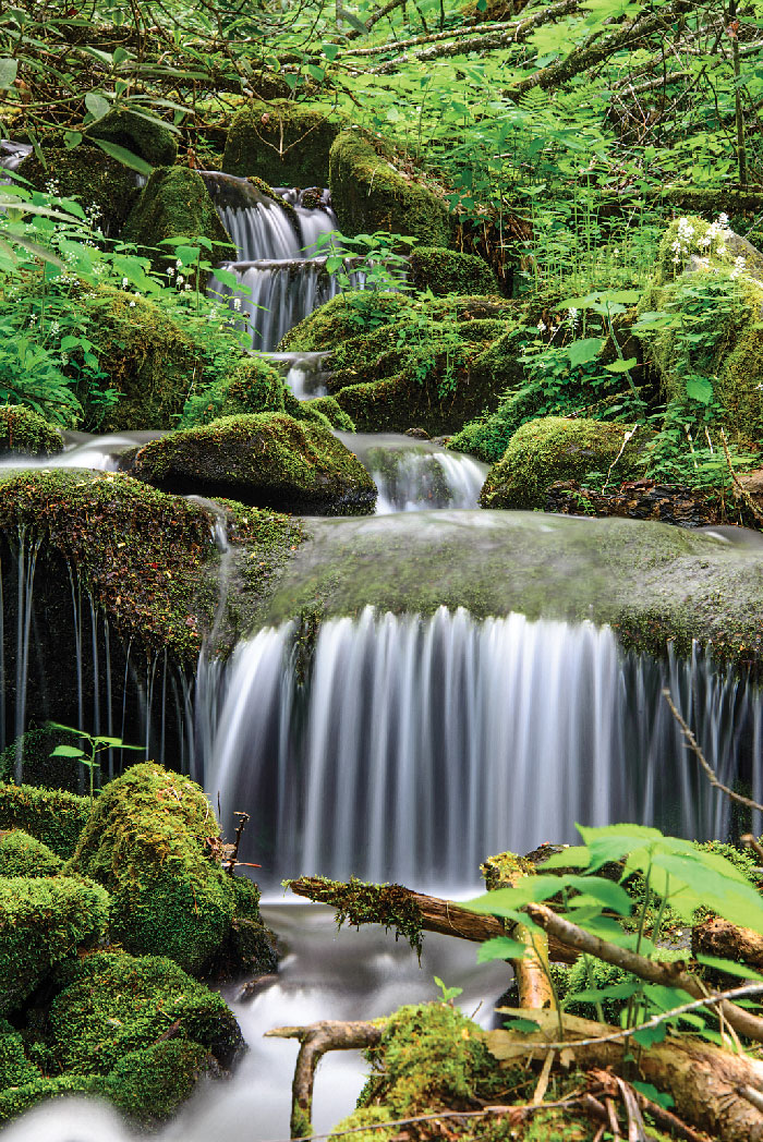
Waterfalls abound in the Smokies, and they come in all shapes and sizes. A fun travel theme for RVers exploring the area is to search for and hike to the most dramatic ones.
We piled back into our truck and continued on Newfound Gap Road to higher and higher elevations. As we rounded a series of switchbacks, suddenly the mystical beauty of the Smokies revealed itself at several scenic overlooks. Gray, misty layers of mountains rippled into the distance. Each overlapping band of undulating hills drew our gazes further out along the ridges until they melted away at the horizon in ever-whiter shades of pale. This was the classic image of the Smoky Mountains that we had always held in our minds.
Turning west, we made our way to the highest peak in the Smokies, Clingmans Dome, along a curved ramp that winds its way up to a 360-degree lookout. Groups of tourists took turns taking photos of each other against the iconic backdrop of the Smokies that rose and fell in waves and faded into soft, silvery hues. As we began our descent back to Cherokee, the sky erupted in a glorious spray of pinks and reds, and we stopped at every overlook to soak up another majestic view of the sunset.
On another day, we discovered a little-known and unnamed gem of a waterfall on the south side of Newfound Gap Road, about 8.5 miles from the Oconaluftee Visitor Center. Scrambling over rocks and leaves, we followed the splish-splash of the waterfall toward its source, going up hundreds of feet into the woods to watch the water tumble down over mossy rocks.
The serenity of this wild place captured our imaginations, and after spending a delightful few hours by the side of this waterfall, we were inspired to look for more. We discovered that three tall beauties can be enjoyed in one easy hike about 9 miles west of Cherokee, near Bryson City in the Deep Creek region of the park.
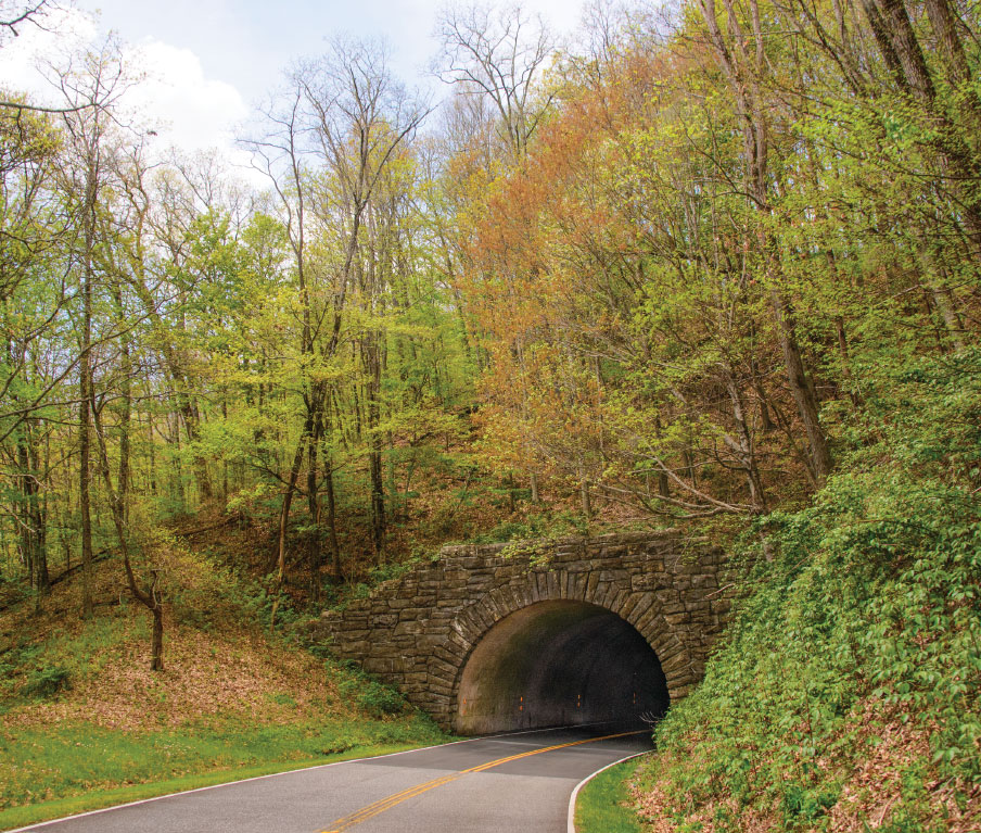
On the southern half of the Blue Ridge Parkway, pretty stone tunnels cut through the mountains. For RVers with bigger rigs, it’s best to explore this part of the route by tow vehicle and leave the trailer at a campsite.
At Juney Whank Falls, the National Park Service has set up a bench on a bridge right in front of the waterfall, and it was a lovely spot to enjoy a picnic while watching the water crash down a sheer cliff face just a few feet from us and then slip away behind us under the bridge.
Hiking just a short distance farther, we came to Tom Branch Falls, a tall and skinny stream of water that trickles down the side of a mountain across the river from the hiking trail. A father and his two kids waded out into the river to get a closer view of the waterfall, and then two girls on tubes came floating past us all. They clicked photos on their cell phones as they drifted by, lounging in swimsuits in their tubes.
The last bit of this easy hike took us to Indian Creek Falls, which is as squat and wide as Tom Branch Falls is tall and slim.
BLUE RIDGE PARKWAY
One of the greatest charms of the Smokies in the springtime is the explosion of color as the wildflowers bloom, and all along this leisurely waterfall hike we passed gorgeous mountain laurel trees whose delicate blossoms danced in the breeze and gave off the most delicious fragrance.
On Top of Old Smoky
Newfound Gap Road (U.S. Route 441) takes motorists from Cherokee, North Carolina, across Great Smoky Mountains National Park in less than an hour, but don’t rush it. Savor the 3,000-foot ascent through northern hardwood and evergreen forests. Get out and stretch your legs on the Appalachian Trail. And don’t miss the 7-mile detour up Clingmans Dome Road to the Smokies’ highest point at 6,643 feet.
Likewise designed for leisurely driving, the Blue Ridge Parkway has plenty of pullovers for admiring alpine vistas. Stop at the Haywood-Jackson Overlook near mile marker 431 (about 38 miles from Cherokee) to hike the 1.5-mile loop trail over the summit of 6,410-foot Richland Balsam Mountain, among the 20 highest peaks in the Appalachians. The next overlook, a third of a mile away, claims the highest elevation along the 469-mile parkway, 6,053 feet, and is known for its stunning sunset views.
Two low tunnels (lower than 11 feet 1 inch at mileposts 458.8 and 459.3) make this southern portion of the parkway tricky for taller trailers. Leaving our fifth-wheel at the campsite, we enjoyed day trips and scenic drives in our tow vehicle and got a kick out of going through the pretty stone tunnels that cut through the mountains on the southernmost 75 miles of the parkway. Although the parkway is managed by the park service, there is no fee or pass required to drive it, and loads of local mountain roads intersect it, making it a cinch to hop on and off.
Who’s Number One? With 10.7 million visitors, Great Smoky Mountains was the most visited of the 59 designated national parks in 2015, but the Blue Ridge Parkway was the most popular of the National Park Service’s 410 overall sites with more than 15 million visitors.
Big bushes were beginning to flower along the roadsides as well, and 3 miles north of Cherokee, when we turned east onto the beginning of the Blue Ridge Parkway, we found bright-orange azalea bushes dotting the sides of the road. White trillium flowers peeked up between brown leaves in the woods.
The 80-year-old Blue Ridge Parkway is a favorite among motor-cyclists, and we saw endless groups of bikes enjoying the sweeping turns and rolling hills as they rode under the canopy of green trees that frame the route.
With our appetites whetted for beautiful waterfalls, we sought out more along the parkway. Literally dozens flow within a short distance of Cherokee. We hiked down to stunning Soco Falls, just 17 miles from Cherokee via the parkway and an easy 10-mile return trip on U.S. Route 19. There is a viewing platform about halfway down the falls, but we discovered these waterfalls are most stunning if you brave the brief scramble all the way to the bottom. From this low vantage point, the twin falls towered above us — an impressive sight as they plunged straight down with a thunderous roar onto the rocks below.
A trio of local little kids was playing in the water near the base of Soco Falls while we were there, happily fishing for trout and collecting their catch in buckets.
“Look, we caught eight fish!” one kid announced proudly to my husband, Mark, while holding up his bucket. Mark raised his eyebrows and asked what they planned to do with them all.
“Eat them, of course!’ was the proud reply.
Two more exquisite waterfalls lie along the Blue Ridge Parkway a short distance from the town of Spruce Pine, about 100 miles or so northeast of Cherokee as the crow flies. To get there, we took a shortcut up Interstate 40 and were stunned when we suddenly passed a vibrantly colored field of wildflowers right next to the freeway just west of Asheville. We pulled over and were soon thigh-deep in crimson and pink flowers that stretched as far as we could see across a vast meadow. Motorists of all kinds pulled off the highway along with us to wade out among the red blossoms and immerse themselves in springtime.
Crabtree Falls is at milepost 339.5, and we enjoyed an easy hike down. It is a lofty waterfall, and a tall curtain of white water cascades over hundreds of rocks on its way to the bottom, forming a fantastic mosaic of silky spray. While the hike down had been a breeze, going back up was a good stair-stepping workout.
Linville Falls is located just 20 miles northeast on the parkway, and when we stopped at the visitor center for a hiking map, we discovered there are actually two waterfalls. With overcast skies looming, we decided to take the shorter hike to less visited Duggers Creek Falls first, and we were almost instantly engulfed in a torrential rainstorm on the trail.
After a mad dash back to the truck to hide out from the deluge, we resumed the hike an hour later and arrived at the falls to find the water was now foaming and creating wonderfully artful swirls, as the bubbles slipped downstream under a small bridge. We reveled in the unique beauty of this tiny canyon so long that the afternoon escaped us, and we never made it to Linville Falls.
The magnificent landscapes of the Blue Ridge Mountains captivated us, and we loved traveling during wildflower season with waterfalls as our guiding theme. We’re eager to make a return trip — with Linville Falls at the top of our bucket list — but next time we’ll try a different emphasis, perhaps focusing on fall foliage or wildlife sightings.
Camping in the Appalachians
BLUE RIDGE PARKWAY
The Blue Ridge Parkway Association’s printed and online directory provides maps and information for RV parks along the parkway, organized by geographical regions. The directory also lists landmarks and other attractions along the route.
828-298-0398 | www.blueridgeparkway.org
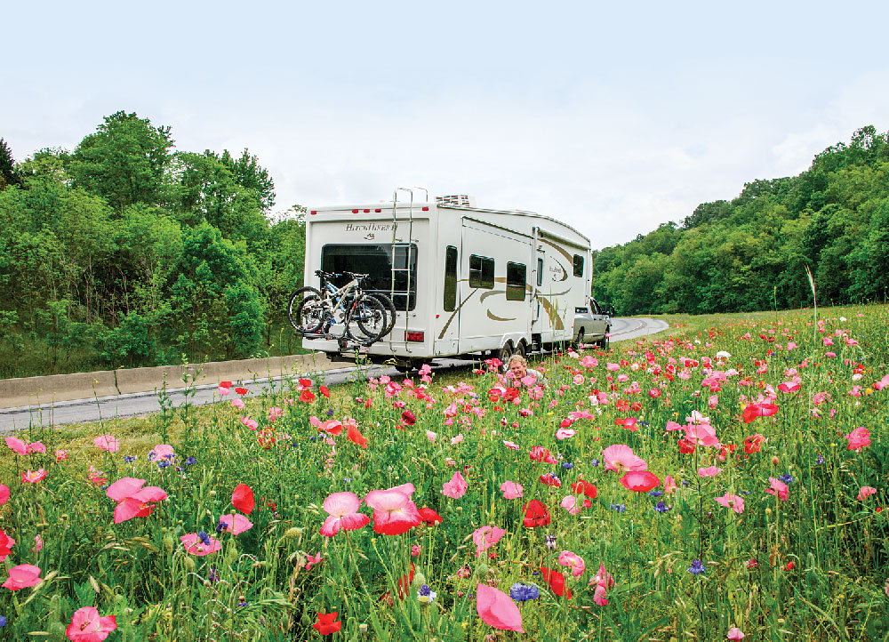
From Interstate 40 west of Asheville, a field bursting with pink and blue wildflowers presented an ideal spot to pull off the highway and take some photos.
GREAT SMOKY MOUNTAINS
America’s most-visited national park has nine developed campgrounds with campsites that accommodate RVs, but no hookups.
Five campgrounds take reservations; the others are first-come,
first-served. Maximum RV length varies.
865-436-1200 | www.nps.gov/grsm
GOOD SAM PARKS
Offering campsite discounts to Good Sam members, the following RV parks are located in Cherokee near the main North Carolina entrance to Great Smoky Mountains National Park and the southern entrance to the Blue Ridge Parkway, making them ideal base camps.
Fort Wilderness Campground and RV Park
828-497-9331 | www.fortwilderness.net
Happy Holiday Campground
828-497-9204 | www.happyholidayrv.com
Yogi Bear’s Jellystone Park — Cherokee
877-716-6711 | www.jellystonecherokee.com
Find more RV parks at www.goodsamclub.com/findacampground.
 Trailer Life columnist and frequent contributor Emily Fagan has traveled full time by RV and sailboat with her husband, Mark, since 2007. The couple’s photos have appeared on more than 25 magazine covers and wall calendars, and Emily’s lifestyle, travel and how-to articles have been featured in more than a dozen RV and sailing publications. Follow their adventures on their blog, Roads Less Traveled.