By early morning of day 10 on our five-week Route 66 odyssey we had said goodbye to Amarillo, Texas, and were watching this town of horses, cowboys, rodeos and more fade from view in our pickup’s rearview mirror. For the next two weeks we would be en route to Flagstaff, Arizona, a trip that includes some of the finest attractions the United States has to offer.
Cadillac Ranch just west of Amarillo hardly falls into this category. But the whimsical row of 10 antique Caddies (1949 to 1963), liberally decorated with sprayed-on graffiti and buried hood-deep in the ground, while not actually on Route 66, has been an icon for decades of the old road.
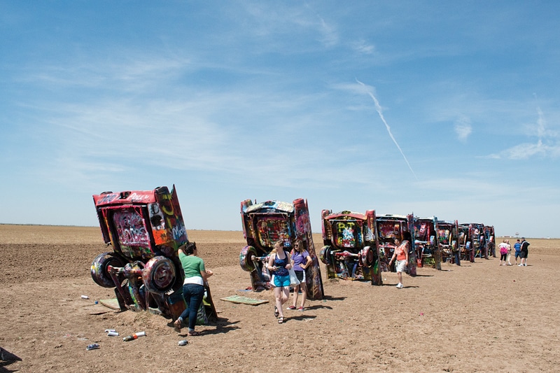
Stop and smell the spray paint at the Cadillac Ranch!
Created in 1974 for millionaire Stanley Marsh 3 to represent the “Golden Age of the American Automobile,” Cadillac Ranch is visited by more than 25 million Route 66 travelers every year. Cans of spray paint for visitors to use lie on the dusty ground between the cars, and there’s no shortage of takers.
From Amarillo west to the state line is about 70 miles. The old road parallels the westbound lane of Interstate 40 through country where no hills break the view to the horizon in any direction, and trees are rare as rubies.
At Vega, Texas, population 884, we recommend visiting Dot’s Mini Museum. Owner Betty Carpenter’s mother, Dot Leavitt, now deceased, came here in 1946 and opened the museum years later. Once-flourishing Vega dwindled after I-40 bypassed it in the 1960s, Carpenter says, but Route 66 travelers stop at the museum, which is crammed with 1940s and ’50s memorabilia.
Just past Adrian, the land transforms into hills, knobs and mesas dotted with fat green junipers. But by the time you reach Gruhlkey, where the frontage road dead-ends and you continue for about 16 miles on the interstate, the hills have vanished.
Glenrio, on the border of Texas and New Mexico, was once a bustling farming community served by the Chicago, Rock Island and Gulf Railway and later by Route 66. The desolate town is now long abandoned by railroad and highway. A handful of empty-eyed adobe homes with sagging roofs remain, and also a vacant post office, filling station and an old-fashioned motel and its sign with letters missing still standing at the old road, where fractured slabs sprout tall weeds.
Nonetheless, the town is a photographer’s dream. Slowly being reclaimed by the desert, it has become a cholla world. These stout treelike cactuses with angular branches and wicked spines belie their true nature in late spring by donning halos of magnificent pink-satin blooms.
These, and the less-lethal prickly pear cactuses, sage, yellow buttercups, white sprigs of lantana and stilettolike yuccas, join in an unending dance, propelled by a hot wind. Looking north you can see termite-size cars moving along I-40, but there is no sound other than the rushing of the relentless wind.
Ahead is New Mexico, which once claimed more than 500 circuitous miles of Route 66 — before the “Santa Fe Loop” was bypassed in 1937 in favor of a straight-line route across the state that shortened the trip by more than 100 miles.
At Glenrio Visitor Center just inside the state line, pick up maps and travel information, then visit nearby Russell’s Truck & Travel Center, a grand 30,000-square-foot establishment. Inside is a retro-style diner, a store and a free car museum featuring two-dozen magnificently restored vintage autos.
You can no longer drive historic Route 66 uninterrupted across the Land of Enchantment, and there are stretches where you must use I-40.
Route 66, lined with old-fashioned motels and RV parks, is still the main thoroughfare through Tucumcari. Neon-lit Blue Swallow Motel was built in 1939 and added to the National Register of Historic Places in 1993.
Other attractions include the Route 66 Photo Museum, where dozens of Route 66 images by Michael Campanelli are exhibited; Tucumcari Historical Museum, with artifacts displayed in a 1903 schoolhouse; and Mission Revival-style Tucumcari Train Depot, built in 1926 and the last remaining railroad building in this former railroad-center town. A Route 66 monument by artist Thomas Coffin is outside the Tucumcari Convention Center and sports a chrome Cadillac-like tail fin and stylized “66” pointed west.
The road winds on through a string of lonely desert towns to busy Santa Rosa, where streets lined with buildings of earth-tone sandstone and adobe could be straight out of Old Mexico. Santa Rosa attracts scuba divers to the Blue Hole, a magnificent azure pool 80 feet in diameter that expands to 130 feet at the bottom, and has a constant temperature of 64 degrees.
Continuing past the Blue Hole you can drive the original Mother Road alignment up into the hills (don’t try it towing your trailer, as the road is steep, winding and narrow). The lonely road, edged with sandstone boulders, junipers, cholla and fleshy lobes of prickly pear, gives a good impression of what driving here in a Model-T must have been like.
Santa Fe is a highlight of any trip to New Mexico, but should you want to bypass it, continue west from Santa Rosa on I-40 to Exit 203, and follow the old road to Albuquerque, where the Santa Fe Loop rejoins the later alignment.
Otherwise, drive north on U.S. Highway 84, the pre-1937 alignment of Route 66, through a landscape of round, flat boulders that could be huge desert tortoises dozing among the junipers. At quiet Dilia, a town that pre-dates Route 66 by nearly a century, aging adobe Sacred Heart Church, a handful of empty houses and an old garage all seem to be melting back into the earth.
Santa Fe is a shopper’s paradise.
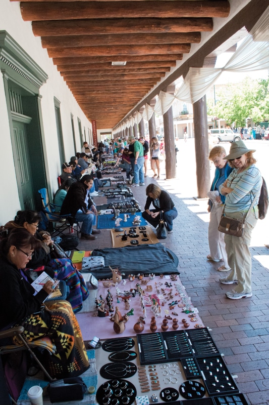
The old road proceeds west and retraces the final 58 miles of the 19th-century transportation route Santa Fe Trail into the state capital. Though the interstate is never more than a few dozen feet away, it’s hidden by thick stands of junipers. Santa Fe is a town rich in art and four centuries of history. This is a shopper’s paradise. Santa Fe claims more art galleries per capita than anywhere else in the country, many of them located along a mile-long stretch of antique Canyon Road. There’s a large farmers’ market at the railyard where you can buy everything from lemongrass soap and chili powder to beeswax candles and fine baskets. Elsewhere, under the south portico at the Palace of the Governors, dozens of Native Americans market their hand-crafted jewelry and pottery. A highlight of our visit was an afternoon at the Georgia O’Keeffe Museum.
We also attended a Confirmation Mass at the magnificent Cathedral Basilica of St. Francis of Assisi. The Romanesque-Revival cathedral was built between 1869 and 1886 on the site of a 1714 adobe church that in turn had replaced a 1626 church destroyed during the Pueblo Revolt of 1680.
Leaving Santa Fe, Route 66 heads southwest toward Albuquerque. Today much of the old road can’t be driven and you follow I-25. But at Exit 264 you can drive four miles west on New Mexico Highway 16, then right on the paved road for about a mile to a narrow, rutted road leading to the foot of La Bajada Hill. You don’t want to drive this road as it is the most difficult segment of old Route 66, and is advisable for only four-wheel-drive vehicles.
As you head for Albuquerque, watch signs carefully as following Route 66 at this part is tricky. Albuquerque is popular for outdoor activities, particularly hiking, biking, golfing and ballooning. For a week in early October the city celebrates the annual Albuquerque International Balloon Fiesta, with more than 500 colorful hot-air balloons taking to the skies as more than 800,000 visitors watch. Balloon rides are available year-round. Like Santa Fe, Albuquerque is rich in art.
West of Albuquerque, past Exit 126, old Route 66 loops back and forth, paralleling I-40 to the state line. About eight miles east of Grants the ground suddenly becomes a veritable moonscape thick with crusty black lava, broken slabs, cracked domes and depressions. This is McCarty’s Pahoehoe Lava Flow at El Malpais National Monument. It’s one of the country’s more recent lava flows, occurring 3,000 years ago. Today the area is popular for hiking and enjoying scenic overlooks.

To see some recent geological activities, you can’t find a better spot than the El Malpais Lava Flow.
In Grants, nicknamed “Uranium Capital of the World,” you’ll find the New Mexico Mining Museum. In 1950 a shepherd named Paddy Martinez found an odd yellow rock nearby that turned out to be from the largest uranium concentration in the world. A 30,000-pound drill bit is displayed outside the museum and is made up of 19 cylinders of varying sizes all edged with rows of dragonlike teeth, which drilled a 10-foot diameter shaft 2,234 feet.
Route 66 continues west toward Gallup through some of the most magnificent landscape anywhere. Tall mesas with long, oddly configured red flanks parallel the road. Red Rock Park, which appeared in the 1940 film The Grapes of Wrath, offers picnic areas, RV camping and hiking on several short trails.
Just past Thoreau the road crosses the Continental Divide, and shortly rolls into Gallup, the “Adventure Capital of New Mexico.” Route 66 winds back and forth across I-40 another two-dozen miles, crossing into Arizona at Lupton. The Copper State, with some 385 miles of Route 66, offers travelers more natural treasures than any other state, among them Petrified Forest, Painted Desert, Sunset Crater Volcano, Meteor Crater and Grand Canyon.

The Petrified Forest is just a stone’s throw from several other great spots.
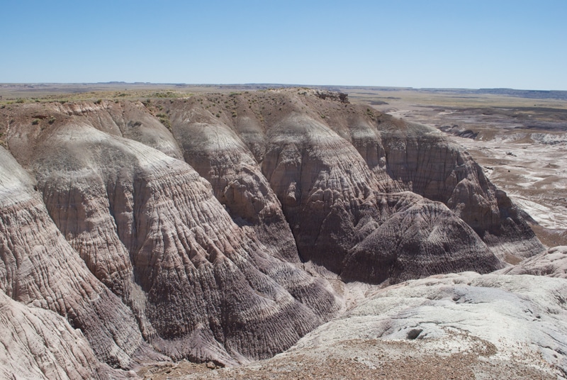
Today, where you can’t drive old Route 66 you travel I-40. But the new route also showcases some spectacular scenery, such as the stretch between Lupton and Holbrook, where you pass Petrified Forest and Painted Desert. Painted Desert’s breathtaking landscape was sculpted by erosion to reveal fossils within the multicolored layers of stone.
President Theodore Roosevelt established Petrified Forest National Monument in 1906. In 1932, 53,200 acres of the Painted Desert were bought and added, and 30 years later Congress designated the monument as a national park. In 1970, 50,000 acres of the park became one of the National Park System’s first wilderness areas.
Today you can follow a 28-mile route through the park which offers numerous overlooks for stunning, high-up views of the colorful mesas, buttes and badlands spread below and stretching for miles.
Continue into a surreal landscape of cone-shaped hills, dried-up streambeds snaking among the hills and low peaks rising from brownstone swirls. Splintered rounds of multi-colored petrified wood protrude from gritty hillsides, and tree trunks lie broken into huge chunks, resembling the plated spines of dinosaurs.
Holbrook, ahead, has a number of attractions, including International Petrified Forest, Dinosaur Park and Museum of the Americas, Rainbow Rock Shop, Route 66 icon Wigwam Motel with 15 teepee-style units, and Joe & Aggie’s 1943 Café.
Continue along the interstate to Exit 257 and follow the old alignment a short distance to Kinsley and Second streets, where you can get out of your rig and be “Standin’ on the Corner in Winslow, Arizona.” Ahead (Exit 233), take the short side trip to Meteor Crater National Landmark, the best-preserved meteoric crater on the planet. Created 50,000 years ago, it measures nearly a mile across and 550 feet deep. Guided trips take visitors into the moonscape crater, which was used to train Apollo astronauts.
Drive on, but “Don’t forget Winona.” Here the old route pulls significantly away from the interstate and heads north toward Flagstaff, leaving behind the desert for cooler temperatures and pine-statued hills.
Busy Flagstaff has numerous attractions, among them “America’s Mountain Garden” at the 200-acre Arboretum; the Pioneer Museum; Museum of Northern Arizona; and the Riordan Mansion State Historic Park.
Highlights of our visit included a motorcycle ride a dozen miles north of Flagstaff to Wupatki and Sunset Crater Volcano national monuments. You can, of course, drive your pickup, but Peter and Mickey Fischer of EagleRider Rental Shop offer a more unusual experience: a ride to the monuments through these picturesque hills on a Harley. (Flagstaff location, call 928-637-6575; U.S. rental and tour information, 888-900-9901.)
Our last stop was at Flagstaff’s newest outdoor attraction, Flagstaff Extreme, where visitors “play in the trees.” The adventure course includes 72 bridges, swings, slides, nets, zip-lines and other “elements” suspended between sturdy ponderosas 15 to 60 feet high, for several levels of difficulty (the full adult course takes about three hours). Since you’re safely fastened into a harness and observed by safety patrollers and rescue guides on the ground, getting hurt seems unlikely. Anyway, it’s a lot more thrilling than scary. Call 888-259-0125 for information and reservations.
More Sights Along Historic Route 66 From Amarillo, Texas, to Flagstaff, Arizona
 From Santa Rosa we suggest taking a 10-mile side trip south to tiny Puerto de Luna where, according to legend, Coronado’s conquistadores built a bridge across the Pecos River in 1541. New Mexico Highway 91 winds through rugged hills striated red and white and bulging with huge boulders to the near-deserted town.
Established in the 1860s, it’s one of the state’s oldest settlements, and served as Guadalupe County seat from 1891 till 1903, when the seat was moved to Santa Rosa.
The 1882 sandstone and stucco Nuestra Senora de Refugio Church and roofless red-stone courthouse are of interest, as are a dozen or so ancient adobe houses with corrugated metal roofs. Roads have poetic names: Rattlesnake Canyon, Blue Jay Road and Kid Lane, named for Billy the Kid (William Bonny) who, according to a sign, had friends here and visited frequently.
 From Rowe, about 25 miles east of Santa Fe, take a short side trip to 6,670-acre Pecos National Historical Park. Exhibits at the visitor center explain that pre-pueblo people settled here around 800 A.D. Three hundred years later several small villages grew up, including one at the site of Pecos Pueblo ruins. Two centuries later most of the villages were abandoned, but Pecos Pueblo had grown larger, probably for better defense against marauding Plains Indians, and by 1450 it was a veritable fortress five stories high with about 2,000 residents.
In 1541 Coronado and his army, searching for the mythical cities of gold, reached the Pecos and were received with music and gifts, but soon returned to Mexico. Spaniards came back to stay 60 years later, this time as colonizers and missionaries. Directed by Franciscans, the Indians built a church, the largest of New Mexico’s mission churches, near the pueblo.
 In 1680, weary of Spanish domination, the pueblo dwellers revolted, destroying the massive church and driving the Spanish back to Mexico. They again returned a dozen years later to a peaceful welcome and built another, smaller church, Nuestra Senora de los Angeles de Porciuncula, the shell of which you see today. Eventually disease, Comanche raids and migration took their toll on the pueblo’s population and by 1821, when the Santa Fe Trail was blazed, Pecos Pueblo was little more than a ghost town. A few years later those remaining left to join relatives 80 miles west at Jemez Pueblo, where their descendants live today.
Visitors to the ruins can walk a lengthy paved trail that winds among ancient kivas (subterranean rooms used for ceremonies) and other sites, including the once-grand adobe church. The park also includes Glorietta Battlefield, site of the westernmost Civil War battle at Glorietta Pass.
 Albuquerque, a town of many attractions, also features Petroglyph National Monument, one of the largest petroglyph sites in North America; the Indian Pueblo Cultural Center; new Mexico Museum of Natural History and Science; American International Rattlesnake Museum; Anderson-Abruzzo Albuquerque International Balloon Museum; and Sandia Peak Aerial Tramway.
Just past San Fidel, New Mexico, we suggest taking a short side trip to Acoma Pueblo, a historic site and “Sky City” that towers 370 feet over the desert floor for spectacular views. Acoma, with more than 300 sandstone and adobe buildings, dates back to about 1100 A.D, and is considered the oldest continuously inhabited community in North America.
Construction of the 21,000-square-foot mission complex – San Esteban del Rey – was begun shortly after the mission at Pecos, in 1629. Today, most of the Acomas don’t live atop the mesa year-round, but return to their ancestral homes for frequent ceremonies, some of which are open to the public.
Guided tours of the pueblo are available most days, and include visits to Haak’u Museum in 40,000-square-foot Sky City Cultural Center, where Acoma art – most notably their decorative pottery – is displayed. There’s also a gift shop and café. The Acomas also run a casino, hotel and RV park; for information call 505-552-1075.
While at the Painted Desert, visit pueblolike Painted Desert Inn, now a national historic landmark. Originally it was the “Stone Tree House,” a privately owned tourist attraction built of petrified wood in the early 20th century.
In the early 1930s it was purchased by the government and remodeled by the Civilian Conservation Corps to resemble a pueblo. Today, park literature and gifts are available at the elegant building.
The park road continues south to a short walking trail to the ruins of Puerco Pueblo, which originally consisted of 100 or so one-story high rooms around a central plaza. Residents – here from about 1250 A.D. to the late 1300’s – farmed adjoining dry slopes and hunted game. Like other Puebloans they made clay pots and carved petroglyphs – bighorn sheep, birds, lizards and other creatures – on nearby boulders.
Don’t miss Wupatki and Sunset Crater Volcano National Monuments outside Flagstaff. In the 12th century, Wupatki Pueblo, now in ruins, was a thriving community of thousands, farmers who worked land in the shadow of Sunset Crater. But by the middle of the next century, after a massive eruption, the pueblo stood empty, the occupants having moved away at the first rumbling. Their descendents – the Hopi, Zuni and Navajo people – still live nearby.
The 1,000-foot-high volcano, a mighty cone of black cinders, is starkly beautiful silhouetted against the sky. The event that emptied the pueblo may have lasted up to a year, and in the process opened additional gas vents, creating miniatures of the volcano itself. Though the lava flow would have killed any living thing in its path, stunted Ponderosa pines thrive here today. And foot-high stalks of penstemon, with showy red (stinky) blooms add rare color to the gritty black ground.
More Information
New Mexico Route 66 Association
505-831-6317, www.rt66nm.org
Arizona Route 66 Association
928-753-5001, www.azrt66.com
Looking for even more fun out on Route 66?