Pay dirt isn’t all RVers can discover along British Columbia’s Gold Rush Trail
Gold fever binds British Columbia and the American West. When Hudson’s Bay Company shipped 800 ounces of gold to San Francisco, California, in 1858, it set off a stampede of gold-crazy miners that rivaled California’s gold rush. Today, RVers can travel past historic buildings, through unique geologic landscapes, and along parts of the original Cariboo Wagon Road to rediscover British Columbia’s Gold Rush Trail.
Instead of driving from our home in Oregon, we fly to Vancouver, British Columbia, and rent a Class B motorhome from Westcoast Mountain Campers. Though we normally drive a larger Class C, this little rig fits the bill.
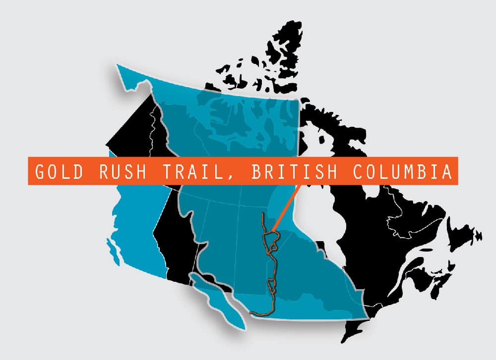
British Columbia’s Gold Rush Trail is more than 1,000 miles long, but we’re concentrating on the Cariboo portion, bordered on the east by the Cariboo Mountains and on the west by the mighty Fraser River.
After loading up on groceries, including some local blueberries at a fruit stand in Vancouver, and churning 90 minutes through suburban sprawl, we turn on Trans-Canada Highway 1 toward the town of Hope and leave the traffic behind. Almost immediately we’re surrounded by massive mountains of the Fraser River Canyon, where fishermen dot the banks of the silty green water and Bridal Veil Falls feathers the face of nearly vertical rock.
We pass through tiny Hope and cross the Fraser River. Even though we’re at an elevation of only 227 feet, we’re already deep in the mountains. This is amazingly rugged country and it’s hard to imagine miners more than a century ago navigating these steep hills.
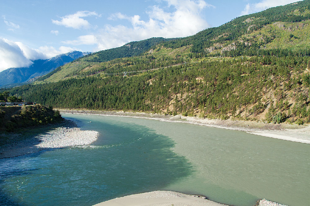
The Thompson River joins the silt-laden Fraser River at Lytton, British Columbia.
The town of Yale is equally small and easy to pass by. Instead, we turn toward the river and Yale Historic Site, with its 1870s Creighton House museum and gift shop, and the rebuilt 1863 St. John the Divine church. The museum contains gold rush items, Chinese and pioneer artifacts, railway exhibits and an impressive collection of First Nations cedar root baskets. However, it’s the living-history tent city, with its grocery, saloon and barbershop, that really illustrates what this gateway to the Cariboo goldfields was like. I try my hand at gold panning and come up with a few flecks.
Fraser River Canyon, Hell’s Gate and a Native Village
We drive out of Yale and into the canyon, now narrow and steep, with the Fraser River a thin ribbon. We pull into Hell’s Gate, the place where the canyon tapers to a mere 115 feet wide. Hell’s Gate got its colorful name from explorer Simon Fraser, who in 1808 described this passage as “a place where no human should venture, for surely these are the gates of hell.”
The Route
The author’s route began in Vancouver along Highway 1, then headed east to Hope, north to Yale and on to Lytton. Following Highway 12 north to Lillooet, the road becomes Highway 99, which leads to Highway 97. Traveling north on 97 to Williams Lake and Quesnel, the author then turned east on Highway 26 to Barkerville.
Traditionally, this was an area where First Nations people fished. It also provided access for miners on their way to the Cariboo goldfields. During the 1880s, the Canadian Pacific Railway built a railroad on the west side of the canyon. Today, it’s the site of the Hell’s Gate Airtram, which gives a bird’s-eye view of this historic landmark and the 200 million gallons of water per minute that thunder through here.
The Airtram, which is dog-friendly and operates every 10-15 minutes, whisks us across the river, where we spot huge gates constructed to help migrating salmon. In 1914 while working on new rail tunnels, the Canadian Pacific Railroad caused a huge landslide that blocked much of the river and decimated migrating salmon runs. These giant gates are an international effort to slow the water and give the fish a fighting chance.
Across the river, we explore the gift shop and an impressive exhibit on salmon life cycle. We resist the fudge and ice cream shop, but indulge in creamy salmon chowder and crispy halibut and chips in the café. After lunch, we walk a dizzying pedestrian bridge over the river before making the four-minute return tram trip.
Just up the road is Tuckkwiowhum Heritage Interpretive Village, a First Nations outdoor museum. Native peoples, including Nlaka’pamux nation (“River People”) have lived in the Fraser River Canyon for thousands of years. Our guide, Carol, dressed in a buckskin dress and ochre-painted face, leads us through traditional summer and winter lodges and exhibits of herbs and foods used by her people. She gives us a sample of “salmon candy,” super-salty air-dried salmon and, in the gift store, I purchase a jar of herbal healing salve reputed to be good for aches and pains.
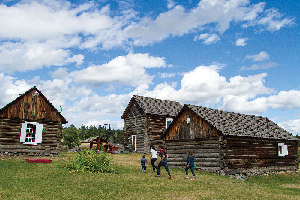
A family explores the 108 Mile House Historic Site’s log structures and exhibits.
It’s 7:30 p.m. when we pass Jackass Mountain summit (1,184 feet) and begin to descend into Lytton. The land is open and drier here, and the fir and cedar have been replaced with pine. The mountains’ granite faces are striated with ribbons of quartz.
Our berth for the night is Kumsheen Rafting Resort. Kumsheen means joining or co-mingling, and this is where the clear Thompson River joins the silt-laden Fraser. While the resort specializes in whitewater rafting, it also has a cozy RV and tent campground, where we hook up the motorhome and head to the onsite restaurant for tasty sirloin steaks.
We wake to cool and brilliant blue skies. In the village of Lytton, we stop at the bridge to take photos of the different colors of the two rivers’ kumsheen. We’re following Highway 12 now beside towering ochre-and-white cliffs, sometimes along the river, other times high above it.
Cariboo Wagon Road and Goldfields
In Lillooet (pronounced lil-LOO-it), we stop at the Miyazaki House, built in the 1880s and home to Dr. Masajiro Miyazaki, a Japanese man interned by the Canadian government during World War II. Miyazaki later became the town’s physician and councilman. The house, a tribute to Japanese Canadians, contains historic area photos as well as artifacts and antique furnishings.
We cross the Fraser into town on the Bridge of the 23 Camels. After gold discovery in 1858, horses, mules and oxen hauled goods to the goldfields. An entrepreneur thought camels would make ideal pack animals, and imported 23 of them. The ill-tempered creatures kicked, bit, and frightened other animals and were released into the wild. They didn’t survive, but this bridge is named after them.
Lillooet is a walkable town, with huge chunks of polished jade along each corner commemorating the town’s old jade mines and its reputation as Canada’s jade capital. While they don’t mine the green mineral anymore, we stop at the House of Jade, where the shop owner’s son tells us those streetside specimens are worth $1,500-2,000 each. We shell out $10 for our own sliver of souvenir jade. This is also the site of the Mile Zero cairn that marks the official beginning of the Cariboo Wagon Road to the goldfields.
We bump down a dirt road north of town and down a narrow drive to Xwisten, a heritage site of the area’s St’át’imc people. Sandra, our cultural guide, joins us for a lunch of fresh Fraser River salmon and bannock (Indian fry bread) and then leads us along a pathway to the Bridge River Fishing Grounds. Along the river are rustic pole structures for processing and drying fish. Sandra shows us how they lay out the salmon, then slice it across several times before hanging it to dry in the warm breezes.
The next morning, we drive along the sagebrush-covered canyon’s windy, steep, avalanche-prone road. We’ve turned away from the river and we’re climbing (elevation 2,529), passing several former slides and Pavilion and Crown lakes. We’re temped to stay at Marble Canyon Provincial Park Camp right on Crown Lake, but it’s early and so we drive on enjoying the white, gray and black marble of this gorgeous canyon.
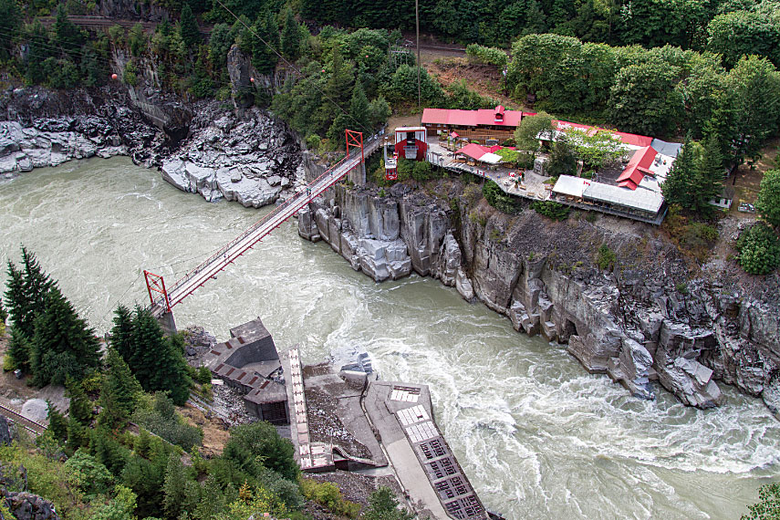
Hell’s Gate tram drops visitors 1,100-plus feet to the visitors center and offers a close-up view of the narrowest section of the Fraser River that Simon Fraser called “the gates of hell.”
We turn west onto BC Highway 97, the Cariboo Highway. At mile 47, in the village of Clinton, we meet Edith, curator of the Clinton Museum. The town grew up around the Clinton Hotel, a roadhouse on the way to goldfields in Barkerville. The hotel burned down in 1952 and the museum has plenty of its artifacts. The museum and a 1911 livery barn are chock-full of antique farm equipment, household items, Chinese artifacts, rifles and even one of those famous camel saddles. Just down the street, you can buy some of these antiques – from old wagon wheels to a child’s spaceship ride – at the Clinton Emporium.
Back on the road, we continue to climb (elevation 3,777 feet) and, just past 70 Mile House, pull into The Sugar Shack for lunch. The owner is a Frenchman from Quebec who makes killer poutine (fries, cheese curds and gravy) and Montreal smoked-meat sandwiches that we devour.
We stop at the 108 Mile House Historic Site, a collection of 1800s and early 1900s log structures, including a massive 1908 Clydesdale barn and a 1911 sod-roofed cabin. It’s Sunday so the museum and many of the buildings are closed, but we mark it on our to-do list for another time.
It’s late by the time we pull into Stampede Campground at the rodeo grounds in Williams Lake. We’ve missed the horse show today, but we’re grateful for the full hookups, level campsite and clean, coin-op showers.
It rains overnight and we wake to broken clouds. As we climb along Highway 97, we note the aspens turning yellow. Fall comes early to this rugged part of the world, and we imagine miners who traveled this route worrying about early snowfall. We’ve rejoined the Fraser River, its mighty green ribbon of silt far below us.
At the town of Quesnel, we turn east onto BC Highway 26 for our final push to the Cariboo goldfields. Fifty miles later, we pull into Barkerville, formerly the main Cariboo Gold Rush town and now a preserved site containing more than 125 historic buildings, many on their original foundations. With a population of more than 5,000, Barkerville was the largest city north of San Francisco and west of Chicago. This boomtown contained everything from live theater to coffee saloons and churches and literary societies. It also had plenty of saloons, brothels and gambling halls. Unlike other gold rush towns that have crumbled into the dirt, Barkerville’s buildings and 187,000 artifacts have been preserved in this National Historic Site.
It’s raining lightly as we stroll the mile-long Main Street. In the 1860s, Barkerville’s muddy streets filled with toxic runoff so they built wooden sidewalks. Today, I’m glad they did. We wander through the blacksmith forge, where the smithy makes iron items like fireplace pokers; visit the historic dentist’s office with its primitive dental tools; pick up cookies at Goldfields Bakery; and, at C. Strouss & Co., warm ourselves beside the wood stove with cups of hot coffee.
In the afternoon, we join in the historic games. Despite on-and-off rain, kids and adults alike happily compete in the hammer throw, egg toss, ladies’ egg/spoon race and pie-eating contest. After several burly men fail, a skinny lad wins a bottle of Canadian whiskey by clambering up a 40-foot greased pole.
Tonight, we’ll eat at Lung Duck Tong Chinese restaurant and stay at one of Barkerville’s forested campgrounds, but, for now, I’ve got to get ready for that pie-eating contest.
For More Information
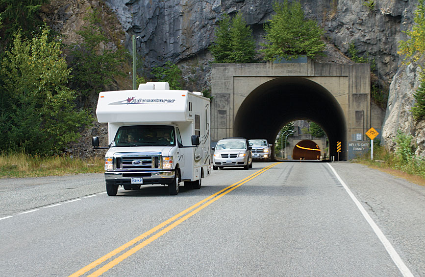
A motorhome plies Highway 1 near Hell’s Gate, British Columbia.
Barkerville Historic Town
888-994-3332 | www.barkerville.ca
Destination British Columbia
www.hellobc.com
Gold Rush Trail
www.goldrushtrail.ca
Hope Valley RV and Campground
604-869-9857 | www.hopevalleyrv.ca
Kumsheen Rafting Resort
800-663-6667 | www.kumsheen.com
Williams Lake Stampede Campground
250-398-6718 | www.williamslakestampede.com/campground