
The second part of an epic Alaska Highway trip travels south from Kluane National Park to the northern Rockies before stepping on the brakes at Milepost Zero
This year marks the 75th anniversary of the legendary Alaska Highway, making it the perfect time to explore the World War II engineering wonder. Like many RVers, traveling the legendary highway had been high on our bucket list. Driving from the highway’s northern end in Fairbanks, Alaska, we’re now halfway to its southern terminus in Dawson Creek, British Columbia.
Haines Junction to Whitehorse
Just south of Haines Junction, Yukon, we spend a night in the shadow of the imposing King’s Throne at Kathleen Lake Campground. Part of  Kluane National Park and Reserve, the no-utilities campground is one of many in Canada’s national and provincial park system offering bargain camping.
Arriving in Haines Junction, we visit Da Ku Cultural Centre, a wonderful exhibit that tells the story of Kluane National Park and the St. Elias Icefield, the largest nonpolar icefield in the world. We’re surprised to learn that glaciers and icefields cover 80 percent of the park, and the St. Elias Mountains are the youngest, fastest-growing and most seismically active on earth.
Leaving town, we spot Our Lady of the Way, an unusual Catholic church fashioned out of a Quonset hut used by the U.S. Army when building the Alaska Highway in 1942 in response to Japanese threats to the West Coast.
A church member tells us, “This is the most photographed church in the Yukon.”
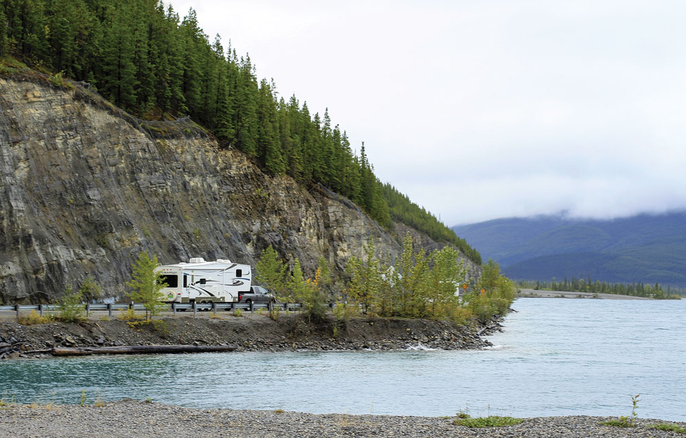
An RVer follows the shoreline of 7.5-mile-long Muncho Lake, a favorite stop for travelers on the Alaska Highway.
As we cruise toward Whitehorse, we stop at the Canyon Creek rest area at the log bridge over the Aishihik River. This historic span, rebuilt by American soldiers during the highway’s construction, is typical of bridges on the original route.
Just outside Whitehorse, the road’s elevation drops, and the land stretches into valleys and ranching country. We pull into Hi Country RV Park, a Good Sam Park in Whitehorse that offers 130 full- and partial-hookup sites, picnic tables and hot showers. We’re thrilled to see the park’s collection of old vehicles — road graders, and a military Jeep and ambulance — from building the Alaska Highway.
Despite having fewer than 30,000 residents, Whitehorse is Yukon’s largest community, and we spend the day shopping for souvenirs for friends and family. Then we stuff ourselves silly with juicy lamb slouvaki, creamy seafood fettuccini and silky tiramisu at Giorgio’s Cuccina, the capital city’s distinguished Mediterranean restaurant.
After a restful night, gray skies and sputtering rain make it a great museum day. We head to Yukon Beringia, a museum that illustrates the story of the ancient Bering land bridge linking Russia and Canada. A 17-minute video tells us this landmass allowed prehistoric people and animals to cross from Asia to North America, including Ice Age mammoths and giant bison.
Beringia’s interactive paleo lab attracts plenty of kids, and the taxidermy and skeletal displays of muskox, sloths, Arctic ground squirrels, giant short-faced bears, wooly mammoths and saber-toothed cats are fascinating.
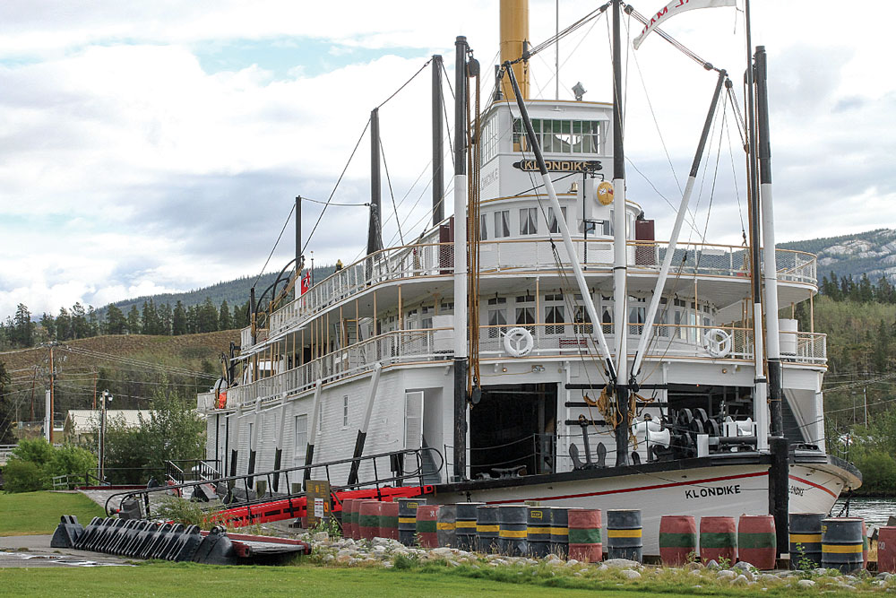
Launched in 1937, the S.S. Klondike II now docks permanently on the Yukon River in Whitehorse. A national historic site, the riverboat is a showpiece of the region’s history.
Our next stop is the Yukon Transportation Museum that displays how goods and people historically moved around Canada’s far north. The surprisingly large museum shows off old railcars, mail sleds, horse-drawn sleighs and early airplanes, including the Queen of the Yukon dramatically suspended from the ceiling. There’s also an Alaska Highway exhibit with vintage military trucks and machinery. Janna Swanks, the museum’s executive director and president of the Alaska Highway Heritage Society, says, “When the highway was built, it was difficult for many Native tribes. But today, it’s the Yukon’s Main Street, connecting all our communities.”
Following a quick lunch downtown, we head to the S.S. Klondike II, a riverboat launched in 1937 that hauled people and goods between Whitehorse and Dawson City on the Yukon River. The boat served until the 1950s and was moved here in 1966 with the help of 8 tons of Palmolive soap flakes to lubricate the skids.
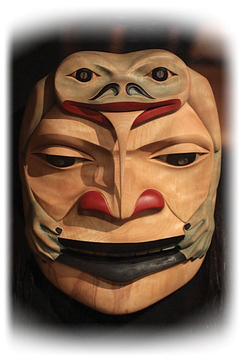
Hunter with Frogman by Tlingit carver Alex Dickson at the George Johnston Museum in Teslin, Yukon.
We take the free self-guided tour and wander the Klondike II’s narrow hold-and-climb stairs to its upper decks. Structural damage prevents us from entering, but we peer into the galley and dining room for a glimpse of past elegance.
Johnsons Crossing to Muncho Lake
The next morning, after stocking up on fuel and groceries, we drive southeast along the Yukon River under low clouds. As we gain elevation, the forest becomes thicker, lakes dot the landscape, and the Big Salmon Range and Cassiar Mountains rise like Titans on either side of the road.
A small “Get Your Buns in Here” sign catches our attention at Johnsons Crossing Lodge, a modest café, motel and campground on the Teslin River. This is the junction of the Alaska Highway and the historic Canol Road, an oil-supply route through the wilderness built at the same time as the Alaska Highway. We’re here for the giant cinnamon buns, gooey swirls we decide are the best on the highway.
After crossing the river, we travel along 78-mile-long Teslin Lake and pull in at the Teslin Tlingit Heritage Centre, an art gallery and community center that celebrates the area’s native population. The carved wood ceremonial masks painted in bright blue, red and black by renowned artists like Alex Dickson are stunning. There’s also impressive beadwork, fur mukluks, handcrafted snowshoes and a caribou-skin jacket. I purchase a carved metal salmon bracelet, and Anne buys a sweatshirt embroidered with a beautiful red wolf.
Just down the road, we stop at the George Johnston Museum. Johnston, a Tlingit photographer, was renowned for driving his 1928 Chevy in the then-roadless village. He painted the car white to use it for hunting and shuttled tribe members across frozen Teslin Lake. The museum features Johnston’s restored car and his photographs of village life.
The day turns soggy, and howling wind rocks the rig, a reminder that weather can be fierce in this lonely country. We pass stands of fire-blackened forest and enjoy peekaboo glimpses of the silvery Swift River. We also encounter moose signs but, alas, no moose.
Our nighttime berth is Nugget City, a complex that includes the Wolf It Down café, cabins, a gift shop, a 24-hour gas station and a large Good Sam Park called Baby Nugget. Most of the gravel sites are pull-throughs with 20- or 30-amp hookups, although a few have 50-amp service. We snag one with free Wi-Fi.
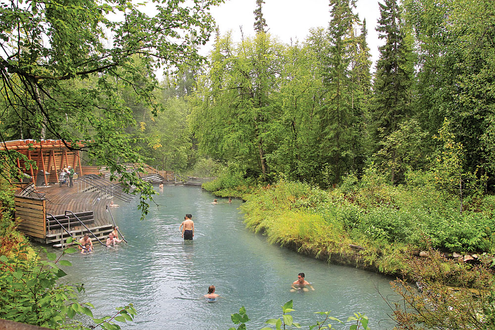
Alaska Highway travelers find warm relief at Liard River Hot Springs in northern British Columbia.
For dinner, we dine at Wolf It Down on barbecue ribs and flaky fish and chips. As we stroll back to the rig, a small bobcat scurries across the campground. While gassing up before leaving the next morning, we avoid filling the freshwater tanks with the iron-flavored water.
We cross Liard River Bridge, one of 233 built by the U.S. Army on the original highway, then stop at the Watson Lake Visitor Information Centre where we’re astounded by a forest of more than 82,000 signs. The practice of posting signs started in 1942 when a lonely soldier tacked up a direction and mileage placard for his Illinois home. Since then, visitors have posted metal, wood and plastic signs with names of friends, family, towns, states and provinces, countries and businesses. Inside the visitor center, we watch an informative video about the highway’s construction and check out the collection of historic photos.
It’s afternoon when we reach the British Columbia border and spot a lone wood bison grazing contentedly along the road. Wood bison, a separate and larger subspecies of plains bison, have been successfully reintroduced into northern boreal forests. We also pass the pullout and interpretive sign for Contact Creek where the two crews working from the north and south met to complete the Alaska Highway.
We trundle down a 9 percent grade, then cross the Liard and Coal rivers, encountering a large herd of bison that includes several mothers and babies.
After pulling in at Liard River Hot Springs Provincial Park, a campground and natural hot springs, we discover that it’s a favorite among locals as well as Alaska Highway travelers. The forested campground has no utilities but offers picnic tables, fire rings and pit toilets. We walk the 1⁄3-mile boardwalk and, after using the changing rooms, slip into warm, waist-high water that melts the road kinks. Ahhhh.
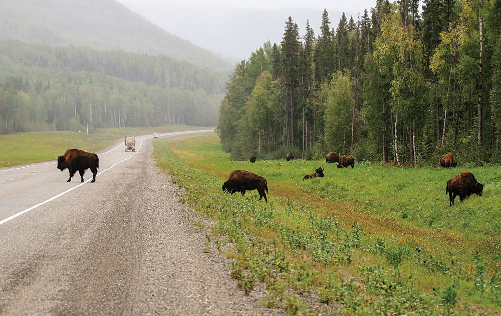
Wood bison cross the 75-year-old highway near Muncho Lake, halfway between Whitehorse, Yukon, and Fort St. John, British Columbia.
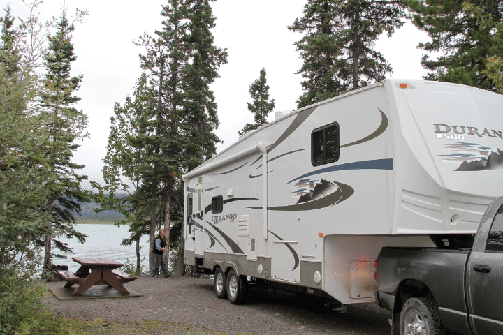
Back on the road, we climb higher, and the temperature drops. When the clouds lift, we glimpse the massive Canadian Rockies, their tops frosted with snow. After pulling into Northern Rockies Lodge, we occupy an RV site overlooking gray-green, 7.5-long Muncho Lake.
Northern Rockies Lodge is favored by hunters and fishermen who fly in from distant lakes, and we have reservations for a flight-seeing tour. However, over a Swiss-style dinner of thinly sliced pork with crispy spaetzle noodles, we learn the weather likely won’t improve. “I’ve got 16 hunters out there, and I can’t get them out,” the lodge’s pilot and owner, Urs Schildknecht, laments.
We lay over at the lodge, reading, napping and doing laundry. When Urs’ son, Daniel, the lodge’s chef, invites us to join him for a rather damp canoe paddle, Anne leaps at the chance. I opt for my novel.
Well rested by the time we leave the lodge, we head to Muncho Lake Provincial Park. At Strawberry Flats, a treed campground snugged against the lake, a hiking trail follows the original track of the Alaska Highway.
We drive higher into the heart of the Rockies and traverse the Toad and MacDonald rivers through boreal forest, the white bark of poplars stark against the spruces’ deep green. At 3,400 feet, snow gathers on the roadsides, and the rain turns to wet snow. At 3,800 feet, the snow is 4 inches deep on the road. At 4,264-foot-high Summit Lake, we pause for a lakeshore lunch.
We’re on the eastern side of the Rockies now, and as we descend, steady rain replaces snow. Along the Tetsa River, we spot two large beaver dams. Then we stop to watch two large great horned owls on a snag. Soaked, the birds look like they, too, wish the rain would retreat.
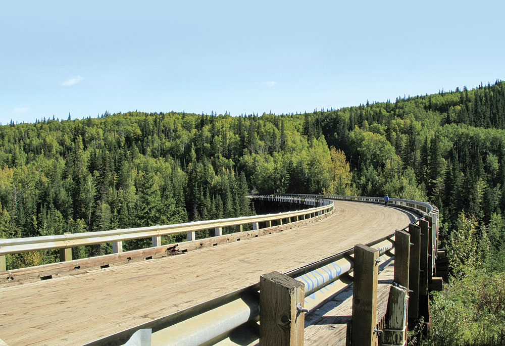
Curving 9 degrees along its 534-foot timber span, the Kiskatinaw Bridge is the only original Alaska Highway bridge still in use.
Fort Nelson to Dawson Creek
In Fort Nelson, we camp at Triple G Hideaway Campground. Our full-hookup gravel site nestles under poplars. Road-weary, we sleep deeply, then wake to blissful sunshine.
At the Fort Nelson Heritage Museum, we meet 80-plus-year-old founder and curator Marl Brown. After showing us the collection of old guns, household goods, timber equipment and taxidermy grizzlies and bobcats, Marl displays his pride and joy, a large garage filled with antique cars and trucks. He points out the 1926 Model T he drove 354 miles to Fort Simpson in the winter of 1975 to illustrate the need for paving the road. “Eleven years later, I drove that car through the opening to the newly paved highway,” he tells us proudly.
Sunbursts follow showers. The magnificent Rockies, their towering peaks in deep snow, continue to tease us before retreating behind clouds. We round a corner, and a small cinnamon-colored bear cub dashes across the highway to join its mother and two siblings. We don’t get a photo, but it’s a treasured moment.
We pull over at Sikanni River Bridge. Black soldiers built the original bridge in record time, and their performance was instrumental in integrating the Army.
At British Columbia’s Muncho Lake Provincial Park, RVers lay claim to a lakeside site at Strawberry Flats Campground.
We reach Fort St. John, an oil and gas town that’s booming. Fort St. John is the largest community on this stretch of the highway and a great place to dine out and stock up on fuel, groceries and other supplies. At Spicy Fusion, we enjoy wonderfully authentic east Indian dishes with deep, complex sauces and crispy naan flatbread.
We camp at Ross H. Maclean Rotary RV Park near Charlie Lake. This big lake was the site of a tragic Alaska Highway building accident where 12 soldiers drowned.
On our last day on the highway, the weather is cool, sunny and spectacular. Fifteen miles north of Dawson Creek, we turn and follow the original highway to the historic Kiskatinaw River Bridge. This curved wooden span is the only World War II timber bridge left along the highway. We stop and walk its truss-and-plank structure, gazing at the rushing water 100 feet below.
From the bridge, it’s a short drive to Dawson Creek. We park at Eighth Street and Alaska Avenue by the famous “Entering the Alaska Highway” sign and check out the visitor center’s rail-depot and natural-history museums. Then we walk a couple of blocks to the Alaska Highway House, a terrific museum that chronicles the building of the highway.
Finally, we stand in the center of the street at Milepost Zero for the requisite photo. We made it! It’s definitely an adventure we’ll remember.

Far-North Favorites
RV parks and public campgrounds pepper the Alaska Highway, including the following Canadian destinations where the author camped on the second half of her journey.
For more places to stay, visit www.goodsamcamping.com.
British Columbia
DAWSON CREEK
Mile 0 Campground
250-782-2590 | www.mile0park.ca/campground
FORT NELSON
Triple G Hideaway RV Park and Campground
250-774-2340 | www.tripleghideaway.com
FORT ST. JOHN
Ross H. McClean Rotary Park RV
250-785-1700 | www.rotaryrvparkfsj.com
MUNCHO LAKE
Northern Rockies Lodge RV Park
800-663-5269 | www.northernrockieslodge.com/rvpark
MUNCHO LAKE PROVINCIAL PARK
Strawberry Flats Campground
250-776-7000 | www.env.gov.bc.ca/bcparks/explore
Yukon
KLUANE NATIONAL PARK AND RESERVE
Kathleen Lake Campground
877-737-3783 | www.reservation.pc.gc.ca
NUGGET CITY
Baby Nugget RV Park
888-536-2307 | www.nuggetcity.com/baby-nugget-rv-park
WHITEHORSE
Hi Country RV Park
877-458-3806 | www.hicountryrv.com
Sesquicentennial Savings
In honor of Canada’s 150th anniversary this year, admission is free at all Parks Canada locations including Kluane National Park and Reserve, and the S.S. Klondike National Historic Site along the Alaska Highway. To take advantage of the deal, order a free Discovery Pass on the Parks Canada website. Regular fees still apply at Parks Canada campgrounds.
Parks Canada | 888-773-8888 | www.pc.gc.ca