In this land of legends, numerous hiking trails cross the range with 5,000-foot peaks rising sharply from the desert floor
It’s said that timing is everything, and ours is impeccable. My wife and I arrived at Superstition Mountain, just east of Phoenix, Arizona, on a day following two days of rain. This was preceded by a month’s worth of storms and snow, the likes of which some of the long-time residents said they’d never seen. It’s early March, the thermometer reads the mid 70s and the desert is awakening. The Superstitions are a range of mountains, with Superstition Mountain being the highest point, popular with hikers and rock climbers. The normal look of a burned-over land of extreme and uninviting terrain has turned green and lush, and is very inviting.

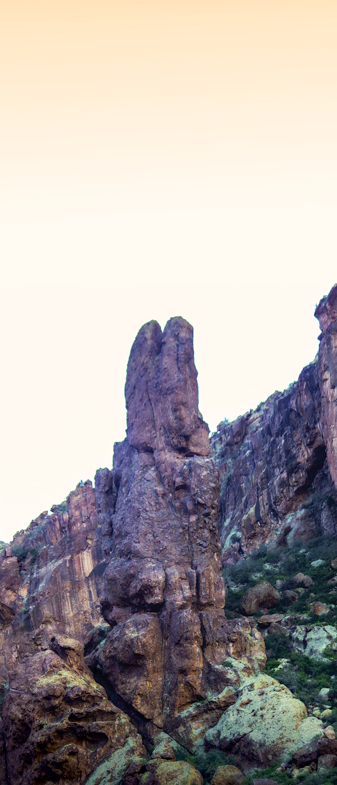
A giant “stone rabbit” watches as we work our way up the trail toward Flat Iron summit.
We’ve entered a land of great spirits, legends and powerful symbols; I know this is true, I’ve had a vision! As we were establishing our temporary fifth-wheel homestead, there was a sound from the sky. It was an engine, but not the normal whine of a turbine, or a small, single-motored propeller-driven craft; it was the deep growl of giant radial engines — not one but several. Looking to the west, there it was; heading east and passing over the majestic mountain, the spirit of a bygone warrior in flight, a B-17 World War II-era bomber. It exhibited the unmistakable profile, the large vertical stabilizer, and the plane’s silver fuselage and wings flashed in the sun. Yes, this is a place of very powerful spirits and the home of legends! And, I’ve envisioned an omen of good times to come.
In our fiberglass Conestoga we establish a claim, and like the hearty prospectors that came long ago, we chose to boondock and not use the available utilities. We camped at the base of the mysterious mountain, its massive jagged walls jutting upward, sometimes in silhouette, other times in the sun’s full reflected glory. The recent rains had produced a landscape of many different hues. The red, brown and beige of the rock and earth were carpeted green with newly sprouting grass. The old Saguaro cacti and awakening desert foliage reaped the benefits of the latest storm. With each passing hour, the shadows moved and the mountain’s appearance changed from what it was a moment ago. Mysterious and inviting, it called to us, and the ultimate challenge had to be met. But take care — legends say many have gone there and some never returned — at least while living!
Building our courage for the confrontation, we scouted the vicinity for added inspiration. Driving the Apache Trail road, we ventured into the land of the great warriors of the past. The rough, unpaved road and the incredible rocky landscape mentally toughened us. The Tonto National Monument tells the story of the cliff dwellers who built their homes and climbed over the rock walls everyday of their lives. These spirits from the past filled our hearts with inspiration.
At the Salt River my wife, Beth, spotted a Bald Eagle gliding along the ridges. Within a short distance of her it landed, and took a bird bath, fluffing its feathers, preening and cleaning itself on the river’s edge, another positive sign in this land of immense power.

The sign on this old mining shack says it all. Guided tours of the Goldfield Mine are available and take you back in time 100 years.
We decided to assault the mountain over two days, from two directions. The first day our trail took us toward 5,000-foot-high Flat Iron summit but we veered to the left. We worked our way across the face of the peak toward the east. In the 70-plus-degree heat, the wildflowers exploded — orange poppies, purple-bloomed lupines and tiny yellow desert sunflowers. Within days thousands more followed.
Leaving the well-beaten path, we clambered up the rocky trail to an altitude of 2,800 feet to the base of the Praying Hands formation. The view is dynamic! In the distance is Camelback Mountain, its triangle shape resembling the single-humped creature it’s named after. Six hours later we were back at our fiberglass-covered wagon — tired, hot and sweaty, but so inspired by the sights we had beheld.
The following day was one of rest, re-energizing and enjoying some cowboy-style grub grilled over the campfire pit. The perfect destination for our day of rest, the nearby town of Goldfield needed exploring. It’s one of the first mining towns in Arizona and flourished in the heyday of the yellow-rock extractions. Now it mines differently, as a tourist attraction. The restored ghost town is full of old wood buildings and massive, rusting mine equipment that carried us to a time when miners and prospectors worked long hours in the hot sun or deep within the earth. There’s a mercantile, a bakery, an art gallery, a sheriff’s office and a church that still holds services on Sunday. The recreational highlight of the roughshod mining town’s entertainment zone, a bordello, stands proudly on Main Street. Unlike the church, it no longer functions and is now a museum. If walking around the hot, dusty street isn’t a pleasure, then there’s the mine train where, for a pittance, one can ride around the site and listen to a guided history of the region. A sarsaparilla bar and ice cream parlor in the town’s café offers a refreshing stop.

A 3-foot western diamondback suns itself on a camp trail.
At 7 o’clock the next morning, when the sun was not yet over the horizon and the surrounding camps were quiet, we crunched the gravel and moved toward our second rendezvous with the towering giant. The climb came in three phases; the first was the lower trail. Park-Service-maintained pathways and the cool morning air made the trek easy. If this avenue continues to the top, maybe it’ll be an easy hike to Flat Iron….
The second phase was through the basin, a huge area of granite smoothed by centuries of water flowing over the surface. When a desert torrent hits this area it turns into a river,

Just outside our fiberglass-covered wagon a quail sits calmly watching us watch him.
the deluge flowing from the top of the mountain through this valley on its way to the desert floor. From the looks of the basin when it rains, it pours, as huge amounts of water have carved out this smooth-rock canyon. We’re in no danger; water flowing from the giant’s top is only a trickle on this cloudless, clear morning. It would make one great waterslide, if there weren’t so many boulders in the way, and a few cliffs to negotiate.
The climb’s final phase was the mountain’s primary resistance; it tested us greatly, but we were determined to make it to the top of the basin. The maintained trails ended, the basin was behind us and ahead lay a barely identifiable track of loose rock and a nearly vertical assent. As one hiker termed it, “It’s the stair-stepper from hell.”
A pattern of painted blue dots on an occasional rock is all that guided us and kept us on course. Flat Iron loomed above us, seemingly laughing at us as we trudged toward the top. Our hike became a series of “take 10 steps and stop to smell the desert roses” — of which there were none. We made a decision: Under a shady overhang our climb ended because my wife’s legs gave out. She encouraged me to go on to the summit, but I, too, declared a draw. From an altitude of 4,000 feet above the desert floor we enjoyed our lunch and an exquisite view into the valley.

Walking across the face of the mountain, the beauty of the desert in spring is evident.
Three hours later we staggered back to our point of departure, exhausted from a hard day’s trek in 93-degree heat. The mountain nearly defeated us in our lightweight hiking gear; I sympathize with those who, loaded down with pick, shovel, backpack and heavy equipment, searched this mountain for a legendary lost gold mine. To those who came before, I salute them and their enduring fortitude!
That evening we watched the Western horizon turn from blue to red and then to blazing orange of a classic Southwestern sunset. In the distance, we heard a cowboy with his guitar serenading the ones who had the vigor to assemble in Goldfield for an evening’s entertainment. Tomorrow, we’d pack up and abandon our claim, but the peak doesn’t care — it is patient. It has been here for thousands of years and many others after us will arrive to test themselves against the mountain of superstition!
If You Go
 Phoenix, where you’ll find numerous RV parks, is about 40 miles from where we stayed at Lost Dutchman State Park. The Lost Dutchman’s main campground takes reservations and there’s an overflow area for those hoping to get sites.
The campground has 72 campsites, a dump station, restrooms and showers, and picnic facilities. Ranger-led hikes and family oriented programs are offered, including ones on getting to know the birds in the park and medicinal plants. It’s the desert, and most of the hiking trails are challenging, so come prepared with proper footwear, plenty of water, sunscreen and protection from the sun.
520-586-2283 | http://azstateparks.com/Parks/loDU/index.html