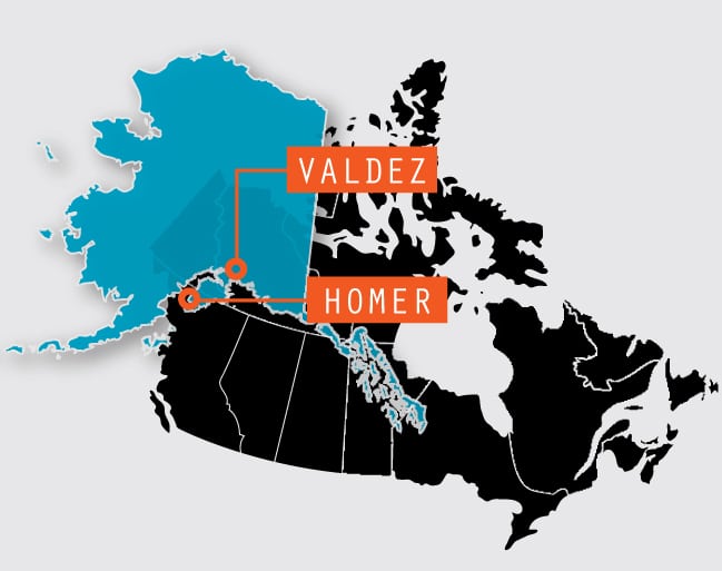
The Third Leg – Homer, Alaska, to Valdez, Alaska
![]()
Now at Homer, we’re roughly at the halfway mark of our great Alaskan adventure with 23 days, and about 2,200 miles behind us. In Part III, we will experience the spectacular scenery of an untouched wilderness and a profusion of mountains, glaciers, fjords and wildlife.
Day 26: Homer to Seward (170 miles)
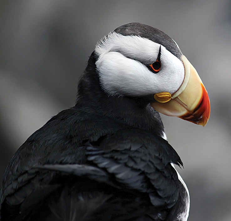
Puffins are one of the most popular Alaska seabirds and can be seen at the Alaska SeaLife Center.
Today we head for Seward. Leaving Oceanview RV Park, we’re back on Sterling Highway, the only road in and out of Homer. Retracing our journey up to Mile 131, where we turn right at the junction of Route 9 and Sterling Highway (Alaska Route 1), we keep going on Route 9 south toward Seward for the remaining 39 miles.
As we drive through the Kenai National Wildlife Refuge, clouds cloak the mountaintops and mist floats through the forest, adding an aura of mystery. Streams, silvery lakes and splendid valley scenery punctuate the rest of the distance to Seward.
 At Mile 161 we arrive at Stoney Creek Avenue, and follow the signs to Stoney Creek RV Park (877-437-6366, www.stoneycreekrvpark.com) with full hookups. Beautifully located, it’s spacious and surrounded by tall trees.
About 125 miles south of Anchorage, Seward sprang up on the shores of Resurrection Bay. Established by surveyors of the Alaska Railroad in 1902, it’s flanked by majestic snowcapped mountains and is Alaska’s northernmost ice-free port, as well as the southern terminus of the Alaska Railroad. This made Seward a vital cargo port and strategic military post during World War II. Today, tourism (especially from cruise ships) and fishing drive Seward’s economy.
Day 27: Seward
Today we visit the Alaska SeaLife Center. Located on Resurrection Bay, at Mile 0 of the Seward Highway, this world-class 115,000-square-foot facility was constructed mostly from Exxon/Valdez oil spill fines. Committed to preserving Alaska’s marine ecosystem, it’s one of the state’s main attractions. Especially popular is the Discovery Touch Pool where visitors experience the underwater world, touching sea cucumbers, sea urchins and more.
In Resurrection Bay, majestic mountains seem to plunge into the deep-blue waters.
While here, we learned that the octopus, an exceptionally intelligent creature, responds to touch. They are hand fed by staffers, who say the octopus’ suckers are gentle, soft and spongy, feeling much “like a baby sucking your thumb.” The sea lion training sessions are particularly entertaining. Anticipating human contact, the animals become noisy and frantic, pushing and climbing over each other, struggling to get close to the trainers. Peering into huge glass tanks, we see harbor seals and sea lions swimming past each other at lightning speed without colliding. The viewing sessions are a great opportunity to observe these animals, but space is limited, so reservations are recommended.
A large aviary on the second level is constructed with rocky grottos, cliffs and a pool. It’s a noisy habitat for many of the bird species that inhabit the Gulf of Alaska. Ducks, puffins, common murre, pigeon guillemot and others all hang out here, loudly claiming their piece of nesting real estate.
Affiliated with the University of Alaska, Fairbanks, the nonprofit SeaLife Center is Alaska’s only public aquarium and ocean wildlife rescue center, helping scientists examine reasons for ecological changes and declining marine populations. Injured animals are rescued and treated before being released into their natural habitat. When they cannot be released, they live here permanently.
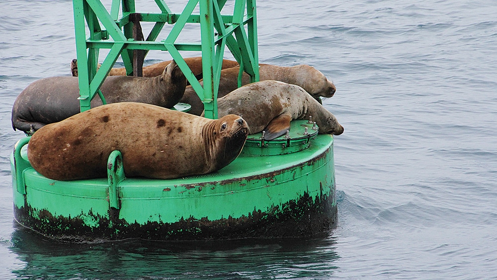
A buoy is occupied by sea lions that watch as our boat cruises by in Unakwik Inlet.
Nearby, on Fourth Avenue, is Seward’s main street, with an assortment of restaurants and shops. We stop at Alaska Nellie’s Roadhouse for some tasty Alaskan seafood chowder, and after lunch we indulge in a couple of ice cream cones.
Next to the SeaLife Center, the city park is a nice place to stroll, relax and have a sandwich. There’s also a statue commemorating the start of the Iditarod trail. Summer brings thousands of visitors here. Stretching along the waterfront, there’s a magnificent a view of the snow-covered mountains and glaciers across the bay.
Overnight RV and tent parking is permitted in the city park along the bay front. Popular and very crowded, these are tight parking spaces. There’s also a dump station nearby.
Day 28: Seward
Today we embark on a 5 ½-hour ferry trip through the world-famous Kenai Fjords National Park in Resurrection Bay. The park ranger on board explains the delicate balance of climate, geology and wildlife here. This enormous bay has some of Alaska’s most dramatic coastal scenery, surrounded by majestic mountains plunging into the deep-blue waters. Ocean waves lap the shores as we exit the harbor and head southeast.
The toe of Exit Glacier can be reached by a moderately strenuous trail.
Shrouded in mist, peace and tranquility abound in these ancient hills and islands. Stretching along the waterfront, towering snow-covered mountains, glaciers and a vast expanse of ancient old-growth forests dominate the scenery. We watch eagles soar high above the trees and sea otters float past on their backs munching seaweed. A pod of Dall’s porpoise suddenly appears, slicing through the water and shoot past the boat as we pass through the Eldorado Narrows.
A rocky outcrop is inhabited by gulls, horned and tufted puffins, all raucously screeching, staking their claim among the nooks and ledges, as their eggs lie precariously near the edge. A little farther on, a colony of seals occupy a rocky ledge lazily sunning themselves.
Suddenly, the skipper’s excited voice announces “humpback whales!” There’s a frantic rush to the outside decks as we all clamor to get photos. This is only the beginning. Later, we see more humpback whales and orcas.
Around 8:40 p.m., we head back to port. Because we are so far up north, sunset comes later and it’s still about two hours away. We enter the harbor and pass several motorhomes parked overnight along the shore at the city park. What a scenic, wildlife-viewing day it’s been!
Day 29: Seward
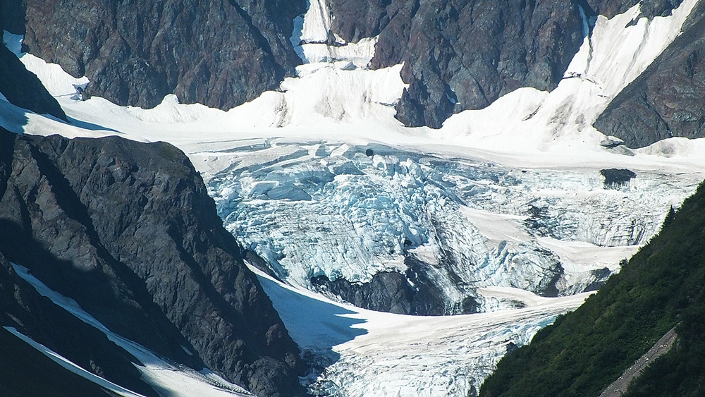
Glacier Viewing: Alaska’s most accessible glaciers include Worthington Glacier near Valdez, Matanuska Glacier near Palmer, Exit Glacier near Seward and Portage Glacier near Girdwood.
Today, our last day in Seward, we head for Exit Glacier. A 15-minute drive from Stoney Creek RV Park, we turn right onto Herman Leirer/Exit Glacier Road. Another 8.5 miles takes us to the paved parking area and Nature Center. Entrance to the park is free, and ranger-led walks to the glacier are available. The marked trail through the cottonwood forest leads to Glacier View for a breathtaking panoramic vista of the glacier spilling down from the Harding Icefield.
The toe of the glacier is reached by a moderately strenuous trail, and brings us face to face with an unforgettable, massive, brilliant-blue wall of ice soaring 200 feet into the sky. If you’re quiet, you can hear the ice crackle and snap. From here, a 1-mile trail loops back to the parking area.
This is an experience not to be missed. Wear layered clothing (it’s cold near the glacier) and comfortable walking shoes. Take drinking water, and your camera.
Day 30: Seward to Palmer (167.7 miles)
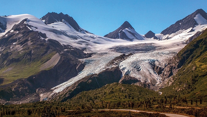
Worthington Glacier, one of the most accessible of all glaciers in Alaska, is 28 miles north of Valdez.
Shortly after leaving Stoney Creek RV Park, we turn right at the Chugach National Forest sign onto Seward Highway 9, heading inland through the dense forest. It’s cool and for the next 10 miles, heavy fog blankets the area, settling on the road, hugging the thickly wooded mountainside and creating a surreal, serene beauty. We turn on the heat in the motorhome and continue climbing. At Tern Lake Junction, we continue straight on Seward Highway, which now becomes Alaska Route 1.
Fifty miles later we’re at Portage, the apex of the Turnagain Arm. We’re here at low tide; the shallow mud flats and quick sands are clearly visible, and though they look innocent, are extremely dangerous. Heed the warning signs and under no circumstances walk out there. People and animals can get sucked in and drown when the rapidly rising high tide returns. Several fatal accidents have occurred here.
The road along Turnagain Arm is a designated scenic byway and rated as one of the world’s most beautiful drives. Snowcapped mountains line the shore, and the fragile beauty is a feast for the eyes. Multiple pullouts provide great photo opportunities.
At Mile 100, Potter Marsh is a bird viewer’s delight. The boardwalk leads from the parking area across the marsh. It’s the perfect habitat for numerous birds. From early May through September, Canada geese, trumpeter swans, and others make this wetland home, especially during the spring and fall migration. Visitors should not disturb nesting waterfowl.
Spawning salmon are seen here between May and August in Rabbit Creek, which flows under the boardwalk, but fishing is not allowed.
We turn toward Palmer at Mile 155, exit onto Old Glenn Highway and continue about 15 miles before turning left onto East Smith Road and follow the signs to Mountain View RV Park (907-745-5747 www.mtviewrvpark.com). There’s ample parking, full hookups and an impressive view of Matanuska Peak.
Day 31: Palmer
Approximately 45 miles north of Anchorage, Palmer rests in the deep, glacial valley of the Matanuska River nestled between the Matanuska and Knik glaciers.
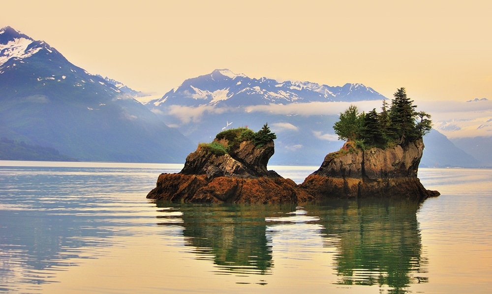
Prince William Sound, located on the east side of the Kenai Peninsula, encompasses 3,800 miles of coastline and is prized for its abundance of marine and coastal life.
Palmer began as part of FDR’s New Deal, a federal program to help stimulate the national economy after the Depression. In 1935, 203 families, mainly from Michigan, Wisconsin and Minnesota, journeyed here to begin new lives. Each family was given 40 acres of land for farming and raising cattle.
At 11 a.m. we arrive at the Palmer Colony House Museum, run by the Palmer Historical Society. Barb Thomas and Mary Ann Anderson (both originally from Wisconsin) welcome us and tell us about their early life in Palmer. Barb came here in 1935 with her parents, and their original homestead is now the Musk Ox Farm. Mary Ann arrived with her family in 1945.
Life wasn’t easy back then. The local hospital was a tent before the residents appealed to Eleanor Roosevelt, who went to the president and insisted they get a proper hospital. World War II and the military presence helped the colony prosper, and some GIs decided to make this their permanent home.
After the Historical Society visit, we sit down for a traditional lunch served at the elegant Inn Café across the street. The Inn was once the old school administration building and dormitory.
Farming is the main occupation here. The growing season is short, but during the long summer days, nearly 20 hours of daylight seems to put vegetables on steroids. Palmer has earned the nickname “land of giants” and can boast of producing a colossal 18.9-pound carrot and a 42.75-pound beet. Each year in August and September, Palmer hosts one of Alaska’s major events, the State Fair, where these gigantic, award-winning vegetables are a major attraction. A monster pumpkin once weighed in at 1,287 pounds. The world-record cabbage, grown in Palmer in 2012, tipped the scales at 138.25 pounds.
Later that day we visit the Musk Ox Farm. Our guide, Shannon, tells us about these ancient animals that once roamed alongside woolly mammoths and saber-toothed tigers in Beringia, the land bridge that joined Alaska and Siberia about 600,000 years ago. Sadly, the oxen were almost hunted to extinction in the 19th century to supply meat to Russian whaling ships.
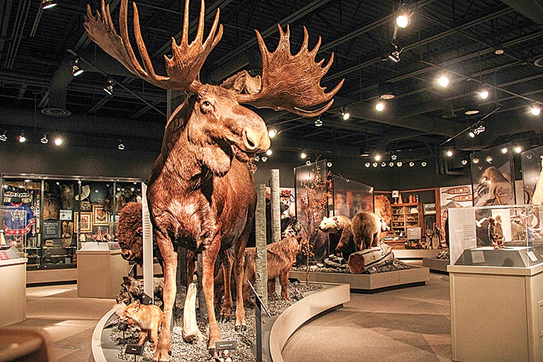
The Maxine & Jesse Whitney Museum in Valdez has one of the largest collections of Native Alaskan art and artifacts in the world.
To rescue these Ice Age survivors, Congress paid $40,000 to move 34 animals from Greenland to Alaska. They were transported by rail to New York, then to Seattle. After the boat trip to Seward, they were transported by rail to Fairbanks, before finally arriving at this farm in Palmer. Incredibly, all the animals survived the journey, and today their descendents are the only domesticated musk oxen herd in the world.
The musk oxen are called “oomingmak” or “bearded one” by the Native Alaskans. Their fur, qiviut, is eight times warmer than sheep’s wool. Collected by nonprofit cooperatives, the ultra-soft wool is distributed to Native Alaskan women, who knit the qiviut into fine garments using traditional patterns that tell stories about their village and Alaskan life. This nonprofit farm is open to the public and well worth a visit (907-745-4151, www.muskoxfarm.org).
We then drive to Wasilla and the Iditarod Museum, which is dedicated to the history of the great race. The Athabascans call their traditional hunting grounds “Haiditarod,” or “a far, distant place,” so in 1910 the trail between Seward and Nome on the Bering Sea was named “Iditarod.” In the winter of 1925, the children of Nome were stricken with diphtheria. The life-saving serum needed was run by a relay of 20 mushers and their dog sled teams, 674 miles across the Alaskan wilderness, in 5 1/2 days. The dog Togo and his musher ran the relay’s longest and most arduous stretch, while dog Balto and his musher completed the final leg through a blizzard, delivering the serum in time to save the children of Nome.
This amazing journey gave birth in 1973 to the famous race, now run through the Alaskan wilderness between Anchorage and Nome, a distance of more than 1,000 miles. Held in March with a ceremonial start in Anchorage, it’s usually completed in nine days and has earned the title “The Last Great Race on Earth.”
Day 32: Palmer to Valdez (260 miles)
Leaving Palmer on the Glenn Highway (also Alaska Highway 1), we drive along the Matanuska Valley. At the Matanuska Glacier State Recreational Site, we soak in an awesome view. It’s the largest glacier in Alaska that can be reached by vehicle. Approximately 26 miles long and 4 miles wide, Matanuska Glacier is classified as a valley glacier, a body of solid ice that flows like a river under its own weight through an existing valley.
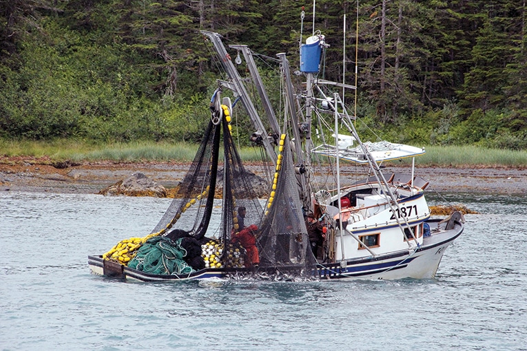
Near Valdez, a fishing boat pulls in its catch.
At Lion’s Head Mountain, an ancient volcano, we pause for an expansive view of the Chugach Mountains and surrounding valleys. Not far from here, Sheep Mountain stops us immediately. This resplendent orange, red, gold and purple mountain is an astonishing sight. Occasionally mistaken for copper and gold deposits, they are actually iron-stained gypsum and sedimentary limestone deposits.
At Eureka Summit, elevation 3,322 feet – the highest point on the Glenn Highway, we soak in the views of the Wrangell Mountain Range and Wrangell-St. Elias National Park and Preserve. This virtually untouched wilderness has the distinction of being America’s largest national park. At 13.2 million acres, it’s six times larger than Yellowstone National Park.
Mount Wrangell is a massive shield volcano and glacier. Sometimes, on a clear day, an unmistakable plume, like a faint sliver of smoke, can be seen escaping from its summit, reminding us that it’s still active!
At Glenallen, we turn right on the Richardson Highway 4, and stop at the Wrangell-St. Elias visitor center to collect information and buy a DVD.
This drive can’t be rushed. The scenery gets better, glacier after glacier, and just when we think we’ve seen it all, there’s more!
The Trans-Alaska Pipeline runs parallel to the road as we head toward Valdez. We’re approaching canyon country, and switch to low gear as we descend steeply on an 8 percent grade. This is the Thompson Pass, a 2,805-foot-high gap in the Chugach Mountains northeast of Valdez.
According to the National Climatic Center, this area holds the highest snowfall record in Alaska, averaging more than 500 inches per year, and the record for the most snow in a single day – 62 inches on Dec. 29, 1955. The world-famous extreme downhill skiing contest takes place here.
Valdez is the southern terminus of the Trans-Alaska Pipeline and Thompson Pass is the only overland link, so the state keeps the highway plowed and ice-free year-round.
Farther downhill we pass Mount Billy Mitchell, a 7,217-foot peak in the Chugach Mountains. With 23 miles to go, we pull over for a view of Worthington Glacier, one of the most accessible of all glaciers – you can walk almost up to the foot of the glacier.
After Blueberry Lake State Recreation Site, another 7-mile-long, 8 percent grade takes us into the heart of Keystone Canyon and two spectacular waterfalls. At Valdez, we check in at Bear Paw RV Park (907-835-2530, www.bearpawrvpark.com) on the shores of Prince William Sound.
Day 33: Valdez
Today we gather at the boat dock for a nine-hour wildlife cruise to Meares Glacier. Leaving Port Valdez harbor we pass through the Prince William Sound, famous for the Exxon/Valdez oil spill on March 24, 1989. Since then, specially equipped Escort Response Vessels escort tankers through Prince William Sound. We watch one tanker leave the harbor, while others wait their turn.
Cruising the bay, we scan the rugged shore looking for wildlife as the captain shares stories and local lore. Eagles make lazy circles in the sky, their keen eyes scanning the water, and occasionally swoop down, expertly snatching a fish out of the water.
After lunch we head for the main attraction of the day, Meares Glacier, located at the head of the Unakwik Inlet.
Stopping within a quarter mile of the glacier, we’re face to face with a 1-mile-wide jagged wall of ice. Suddenly, a sound like distant thunder alerts us. Turning around, we see the glacier calving, as several sections of the ice wall break off and tumble into to sea.
The captain skillfully maneuvers our boat cautiously amid the ice floes, getting in closer to an ice cave. It’s the toe of the glacier. Between our boat and the glacier, seals rest on the ice floes, watching our boat rock gently on the waves. As we head back, we pass various shaped blue icebergs drift by, some quite large. Entering Valdez harbor, we see the 800-mile-long Trans-Alaska Pipeline terminal and port. In its heyday in the 1980s, the pipeline delivered almost 2 million barrels of oil every day.
Day 34: Valdez
It’s our last day in Valdez and we drive a few miles to the Solomon Gulch Hatchery. The hatchery is permitted to incubate 230 million pink salmon eggs and 2 million Coho salmon eggs annually. It releases about 10 million adult pink salmon, while the Coho return is between 150,000-250,000.
This is a rare opportunity to see thousands of salmon, caught in a frantic struggle to return to the hatchery where they were born. We walk along a long weir and watch the fish thrash about as they’re directed toward the hatchery.
The smell of blood in the air, from injured fish, attracts wild animals. Bears, fattening up before their six-month hibernation, are a common sight here, so heed the warning signs and keep a safe distance.
Driving back on Dayville Road to the Richardson Highway, we stop at a bridge where a mama grizzly and her cub are busy catching salmon. Along with dozens of other spectators, we snap some good shots from the bridge.
Heading back to town, we take a diversion and drive through the land where the original Valdez was located. Because of its strategic location, Valdez became a prosperous city, but disaster struck at 5:36 p.m. on March 27, 1964. A devastating 9.2 earthquake, the most powerful recorded in the U.S., set off an underwater landslide, and a colossal tsunami washed away buildings; more than 120 people were killed by the earthquake and subsequent tsunami across Alaska, Oregon and California. Valdez was relocated 4 miles west to its present location. Now a deserted area, a few historical signs are posted along the rough, abandoned roads.
We return to town to visit the Valdez Museum and then head to the Maxine & Jesse Whitney Museum, which is located on Prince William Sound Community College campus and holds rare collections of Alaskan artifacts.
This marks the end of the third leg of our trip. Part IV will include historic Skagway (and the White Pass & Yukon Route Railroad), as well as a high-speed catamaran trip via the storied Inside Passage to Juneau, before completing our journey in Prince George, British Columbia.