Exploring west-central California in the path of North America’s largest birds
The range of the California condor fashions a favorable travel itinerary. Granted, they are mercurial hosts – not unlike rainbows – but when travel routes cross, the outcome is magical. The gigantic birds are both emblems of the past and symbols of survival. They are keepers of the planet and hopes for the future. The arguably ugly bird has risen to a modern-day romantic hero, attracting fanciers from across the United States and around the globe.
During a recent California trip, we were treated to the sight of three black spots gracing the sky over Pinnacles National Park. Because condors can soar up to 15,000 feet, even distant sightings are telling of the bird’s size. When next we met, it was at closer range on the Big Sur coast. Clearly, condors have great taste in travel destinations.
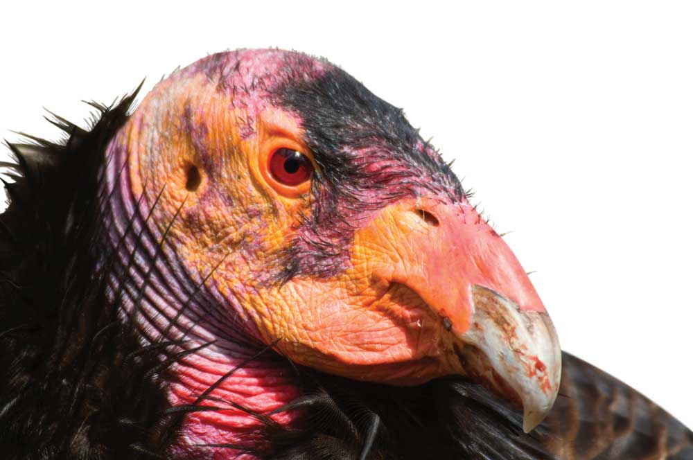
This California condor (Gymnogyps californianus) was photographed at the San Diego Zoo Safari Park in California.
Thanks to the success of the captive-breeding program, the California condor has returned to the open skies, sailing free, albeit radio-monitored. Both the Pinnacles National Park and Big Sur populations boast nesting pairs. The birds fly unrestricted between the two locations.
Our happenstance encounters brought us full circle. Our first-ever article assignment was on condor viewing in the wild in the 1980s at the Condor Watch Site in Southern California. But, before the article reached print, the remaining 22 condors were captured and sent to captive-breeding programs. In retrospect, the condor might not have been the best talisman for a budding career, but we were forever linked. Again finding ourselves together in the wild was a happy reunion.
Condors or no, these premier Central California locations treat with trails, camping, rocky heights and sights, flora and fauna, missions, history, redwoods and one of the world’s most remarkable meetings of land and sea.
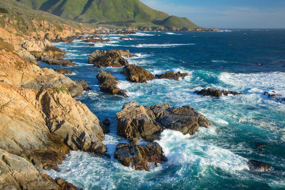
The coast is a dramatic sight from Garrapata State Park along Big Sur Coast Highway Scenic Byway.
Pinnacles National Park
Protected since 1908, this ancient volcanic field only achieved national park status in 2013. Its namesake spire-and-monolith skyline divides the park into road-distant east-west halves. The eastern half sits southeast of Hollister off State Route 25; the western day-use site sits northeast of Soledad. Visitation is high, especially on weekends, holidays and in the spring.
Locals tell me that park interest skyrocketed with the status upgrade and condors’ arrival. Binoculars, spotting scopes, birders’ guides and phone apps serve serious and casual seekers. A common conversation starter on trail or in camp is “Have you seen the condors?”
While waiting for the celebrities, 160 other feathered species may draw note. Miles of trail unfurl the park’s character, beauty and vistas. Some stretch flat, many climb.
Pinnacles, East
Meet the Condors
If you are fortunate enough to read the condors’ tags, note the color and number and go to www.condorspotter.com to learn more about that condor. We spotted female 22, Cosmo, of the Big Sur population, born April 17, 2000, raised at the San Diego Zoo. With her was male 51, Crush, also of the Big Sur population, raised in the Los Angeles Zoo.
Overnighters should point their rigs here and plan on reserving sites. Most RV sites have electric hookups, with water in camp. When temperatures climb, a seasonal swimming pool, coin-operated showers and the shade of the visitor center porch bring relief. During peak-season weekends and holidays, a free shuttle runs between the East Pinnacles Visitor Center and Bear Gulch, which has limited parking (cars only).
Although a strenuous climb to High Peaks offers the best chance for condor sightings, the birds can be seen from camp. Campers point binoculars at the ridges, with the south ridge generally a good bet. Vultures roost nightly in nearby gray pines.
Bear Gulch, with trail access to the popular Talus Caves, cries for an early start. We hiked to Lower Cave (Upper Cave was closed for the Townsend’s big-eared bats). Stairs and railings aid hikers through the rock openings. Trickling water, wet floors, low ceilings, squeezed passages and blackness necessitate flashlights.
Moses Spring, with lovely ferns, suggested a loop return. Hummingbirds fed at bush monkeyflowers, and blooms of the elegant clarkia, chokecherry and succulents held glances. Buckeye, oak, gray pine, sugarbush and toyon interspersed the chunky rock cliffs, balconies, overhangs and bowls.
Condor Gulch Overlook seemed a logical hike destination. For a 1-mile ascent, we attained a fine overlook of the oak-rock canyon and ridge skyline. Large lizards with muscular tails and leopard spots lowered glances. Hikers who mustered on toward High Peaks met up with a biologist and two radio-tracked condors – not an altogether uncommon occurrence.
Tracing Old Pinnacles Trail up a canyon bottom toward Balconies Cave (beyond our late-afternoon intent), we admired quail, butterflies and a king snake. We walked out with a researcher, ending his day, tracking wand in hand. He pointed out three tiny circling birds, more than a mile high. “Condors,” he said.
- While in the Area
- Make a stop at San Benito County Historical Park and Historical Society Village. Separately operated, this duo to the north offers a shady rest and a look at pioneer history: historical farm and ranch equipment, homespun interpretations and rescued structures. View tools for tomato, potato and bean planting, and take a guided look at the Cottage, Saloon and Sullivan House.
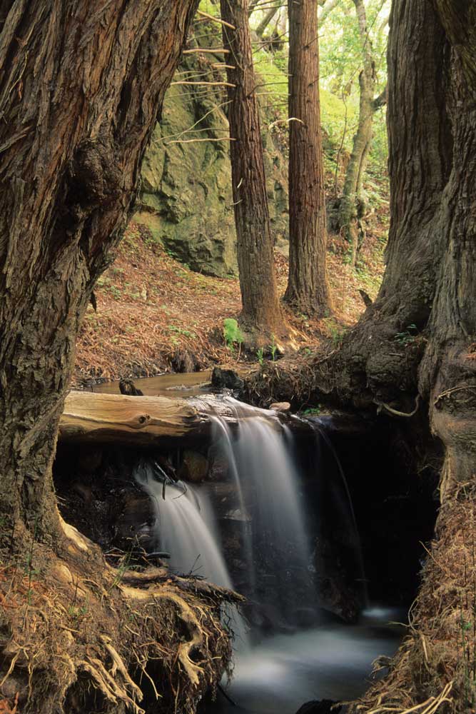
A waterfall among the coastal redwoods along Sobaranes Canyon Trail in Garrapata State Park.
Pinnacles, West
An electronic gate controls access, opening at 7:30 a.m. Visitor station hours depend on staffing. Because the access road is single-lane and winding (15-foot-length maximum), plan to arrive by dinghy vehicle.
We followed Juniper Canyon Trail toward the High Peaks area, passing among juniper, oak, buckeye, madrone, chemise and mid-April wildflowers. Bulky rock towers, boxy boulders, overhangs and ledges kept eyes moving. At the rocky top, lowered clouds and wind-animated mist gave a ghostly aura to the intricately layered temples and pinnacles. Perched on the cross-canyon cliff, we spied a living gargoyle – a condor.
-
- While in the Area
- Mission Soledad (free) invites with calming flowers, statuary, crosses, a cemetery and the covered original ruins. Inside the 1954-restored mission, a museum takes visitors through four periods of mission life: Indian, Spanish, Mexican and Ranchero. Artifacts represented each period, and write-ups discuss the changing faith, food, fun and lifestyle.
- At Mission San Antonio de Padua, (fee site) southwest of King City, pastel borders and a starry vault house the faithful. Artifacts complete the Padre’s bedroom, kitchen and music room. A tanned hide wears the brands of the 21 California missions. Compound ruins reveal daily life: living quarters; threshing floor; olive and gristmills; fields, reservoirs, aqueducts and wells; a tannery; and a Native American cemetery.
- While in the Area
Big Sur Coast
Separated from Pinnacles by the forest-and-canyon expanse of the Santa Lucia Mountains/Los Padres National Forest—Ventana Wilderness, the Big Sur coast hosts a second population of California condors. Highway 1, an American National Scenic Byway, strings its narrow, winding 90-mile length – best for small RVs. Make use of turnouts, the views are great!
McWay Canyon—Julia Pfeiffer Burns State Park called us aside with its stunning 80-foot seaward waterfall, rugged sculptural shoreline and steep redwood canyons and, as it happened, condors. For us, Partington Cove and Tan Bark Trailhead hosted the meeting. Condor watch sources recommend the flagpole area. For RV parking, use turnouts alongside Highway 1.
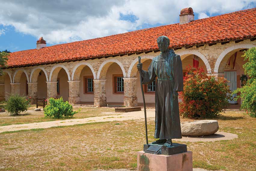
This statue of Padre Junipero Serra, one of the mission’s founders, stands in front of Mission San Antonio de Padua, at Fort Hunter Liggett Military Reservation in Monterey County.
After exploring the redwood canyons of McWay and Partington creeks, we descended the old service road to rocky Partington Cove. It extended a wonderful window to the sea and a wild collision of wave and rock. Stacked hoodoos populated its shore.
On the return hike, six vultures circled overhead, followed by a single condor. The latter returned, circling low, revealing a bright orange head, white underwing triangles, fanned tail and level flight. The vultures served as ready comparisons. While in high-five mode, three more condors glided over us, apparently unfazed by squeals and wild pointing.
Back at the turnout, a juvenile condor with a blackish head landed above Highway 1. Then two adults claimed ledges where Partington Creek meets the highway, winning our spotting scope’s focus for the next hour. The scope, in turn, attracted an entourage of the curious. A businessman motoring up the coast hurried to a stop and ran, suit and tie, down the highway, yelling, “Are they condors? Really? Great!”
Oceanside pullouts between Julia Pfeiffer Burns State Park (Milepost 36) and longtime Big Sur landmark, Nepenthe Restaurant (Milepost 44, to the north), are reportedly good condor-watch stops. An area sea lion haulout attracts the condors with stillborn pups, afterbirth and carcasses. On our visit a whale carcass reportedly raised activity. The east ridge and Discovery Center (with condor interpretation, open summer weekends) at Andrew Molera State Park (Milepost 51), too, may bid stopping. Again, RV parking is alongside Highway 1.
For camping, Pfeiffer Big Sur State Park (Milepost 47) on the Big Sur River served our needs (RVs up to 32 feet). Private campgrounds expanded opportunity. Reserve early.
When condors are absent, consider the Ventana Wildlife Society (VWS) condor cams (www.ventanaws.org/condor_cam). For serious seekers, the Society offers two-hour condor tours on the Big Sur coast for a fee and preregistration. Their use of radio telemetry improves the odds.
-
-
- While in the Area
Big Sur Station (Milepost 46) is information central for touring the coast whether camping, hiking or sightseeing. Here, you can find print materials and videos, including one on Point Sur Light Station. Ask about tours at the 19th-century light station. But know, there is no parking for large motorhomes at the meeting site.
Garrapata State Park, (Mileposts 63-67), a more primitive park, has numbered accesses for coastal and inland trails (beware of poison oak) and is suitably wild for condors. Otters, harbor seals and seabirds may also be spied.
-
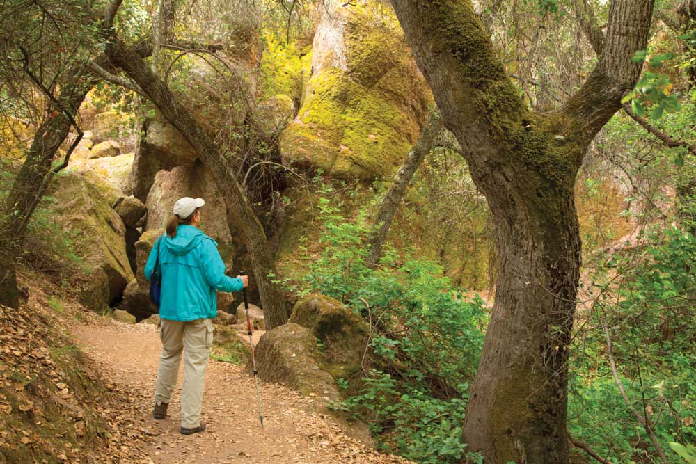
The challenging hike to High Peaks at Pinnacles NP results in a good chance for condor sightings.
Know Before You Go
– Winter 2017 storms caused mudslides that closed a portion of the Big Sur Coast Highway Scenic Byway. As of presstime, the portion of road from 4.6 miles north of Ragged Point to 10.3 miles north of Ragged Point at Mud Creek is estimated to reopen September 30, 2018.
– To reach the prime condor-watching locations, take U.S. Highway 101 to Route 68 at Salinas to Highway 1. From Carmel, the stretch of Highway 1 through Big Sur is open, but once you reach Gorda, approximately 60 miles south, you’ll have to turn around.
– For the latest information, call the Caltrans Highway Information Network (800-427-7623) or visit www.dot.ca.gov/cgi-bin/roads.cgi
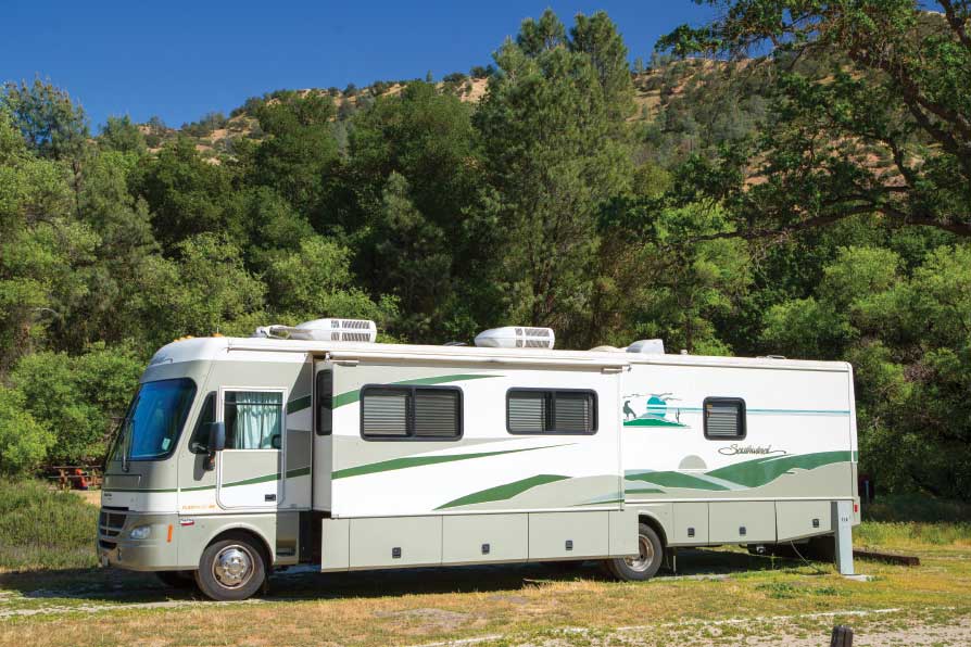
Many campgrounds in the eastern section of Pinnacles National Park offer electric hookups.
For More Information
Big Sur Chamber of Commerce | 831-667-2100 | www.bigsurcalifornia.org
California Parks | 800-777-0369 | www.parks.ca.gov
For campground reservations, contact Reserve America, 800-444-7275 or go online at www.parks.ca.gov
Pinnacles National Park |831-389-4486 | www.nps.gov/pinn
RV sites can be reserved up to six months in advance. Reserve America, 877-444-6777, www.recreation.gov
Ventana Wildlife Society | 831-455-9514 | www.ventanaws.org