A meander along the sweeping northwest coast of Lake Superior, the largest freshwater lake in the world, reveals hiking trails, a historic lighthouse and a folk school that preserves the heritage of Minnesota
On November 10, 1975, the S.S. Edmund Fitzgerald, a 719-foot cargo ship loaded with iron ore, was making headway across Lake Superior when a severe storm hit. The immense lake roiled with 30-foot waves and gale-force winds, claiming the ship and her crew of 29 and making headlines. Newsweek carried the story, inspiring singer-songwriter Gordon Lightfoot to compose his famous ballad immortalizing the shipwreck.
I was 14 years old at the time. I don’t remember the wreck, but the song about the Edmund Fitzgerald’s final hours and “the big lake they call Gitche Gumee” touched my soul. Forty-one years later, the tune remains a favorite. Last summer, after traveling the northwest shoreline of Lake Superior from Duluth to Grand Marais, Minnesota, Gitche Gumee is now a favorite camping destination as well.
My husband, Jack, and I went there on a hunch. While planning a road trip from the Adirondacks in upstate New York to our home in Montana, Lake Superior caught our eye. It’s hard to miss it on a map. The largest of the Great Lakes and the largest freshwater lake in the world by surface area (31,700 square miles), the enormous glacially carved basin on the U.S.-Canada border is 350 miles at its longest point and 160 miles at its widest. However, with 1,826 miles of shoreline (not counting islands), Lake Superior could supply a decade of pit stops on our east-west route. We never did narrow it down to just one.
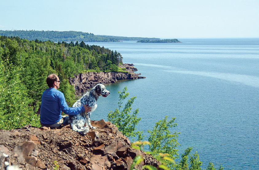
Enjoying the view of Lake Superior’s northwest shoreline, Minnesota’s answer to Big Sur.
Our road atlas revealed little at first glance, just Highway 61, which traveled close to the shoreline through a seaside-sounding town called Two Harbors, a ski town called Lutsen, French-sounding Grand Marais and a smattering of small villages sparsely spread along the 145-mile route from Duluth to Grand Portage at the Canadian border.
Upon closer inspection, Highway 61, the North Shore Scenic Drive, is considered an All-American Road Scenic Byway. The unpopulated shoreline seemed to have a state campground every dozen miles or so. Then I noticed a historic site called Split Rock Lighthouse and a nearby place called Castle Danger. A hiking trail seemed to wind its way north slightly inland from the road.
Lakeside camping, a historic lighthouse, hiking and a precariously named place — Lake Superior’s northwest shore was a destination! Once there, we discovered a mix of intriguing sites, tasty local fare and recreational opportunities, plus a traditional folk school with classes for visitors like us.
First Impression. Heading north from Duluth on Highway 61, we passed through the Silver Creek Tunnel, which cut through a rock cliff above the shoreline. Just past the tunnel exit, we pulled over at a scenic overlook for a view of the lake. During the 17th century, the Ojibwe, a Native American people also known as the Chippewa, migrated westward from the mouth of the St. Lawrence River to the Great Lakes. They called Lake Superior “Gitche,” which translates to “great water” or “great sea.” Watching the blue waves roll on and on to the horizon, Gitche Gumee looked more ocean than lake.
It acts like one, too. When the weather is fair and calm, the lake is a gentle giant, massaging its rocky shore with mellow waves and enticing sailors, motor-boaters, anglers and paddlers to enjoy its waters. But it can turn moody without warning. A strong westerly wind will coax it into a violent frenzy, which is what happened that fateful evening in November 1975 when the famed Edmund Fitzgerald sank. Luckily, the midsummer forecast during our visit was sunny and warm. The dramatic view north along the heavily timbered, cliffy shoreline and across the endless water instilled a welcome anticipation in us. To a couple who enjoys the outdoors, free of crowds and full of nature, we had found the Big Sur of Minnesota.
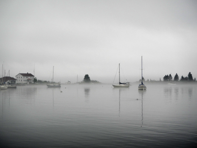
Anchored in a small cove, sailboats bob in the morning mist.
Biking. At the Silver Creek pullout, we also discovered the Gitchi-Gami bike path. About 25 miles of the proposed 88-mile paved recreation trail is complete. Several cyclists pedaled by us, along with a couple of joggers and dog walkers. The path parallels the shoreline and eventually follows it all the way to Grand Marais. Cleverly, the completed sections are adjacent to the campgrounds and towns along the lake, with most of the voids on stretches that are the farthest from the places where the average person is likely to ride.
Camping. We continued north toward our campsite at Gooseberry Falls State Park, the first of the eight state parks along Highway 61 about 40 miles north of Duluth. There are two ways to visit the northwest shore of Lake Superior, either wending one’s way up the shoreline, staying at a different campground each evening, or picking one and traveling from it to various points of interest each day. There’s no wrong choice. Each park is well maintained and near the water, with its own interesting historical and natural sites and educational programs.
We opted for Gooseberry Falls State Park for our entire visit, to take a break from our bigger cross-country trip. The 1,682-acre park is located near the mouth of the Gooseberry River and boasts five hike-to waterfalls, the largest and closest of which is handicap-accessible, and access to the Gitchi-Gami bike trail and the Superior Hiking Trail, a visitor center and several historic buildings.
Two Harbors. En route to Gooseberry Falls, we stopped in Two Harbors, a pretty waterside village overlooking Agate Bay. We took tours of the local lighthouse (the oldest operating lighthouse in Minnesota) and the Edna G, the last working coal-fed, steam-powered tugboat on the Great Lakes. After watching a couple of “lakers” (ocean-bound cargo ships) depart the bay, we poked around the cute shops in town, then stopped in at the Castle Danger microbrewery.
The brewery proved perilously tasty, whereas the actual settlement of Castle Danger, several miles north of Two Harbors, was little more than a benign blip on the highway, so-named either because the cliffs there resemble a castle or because a boat named Castle ran aground there years ago.
Superior Hiking Trail. While in Two Harbors, we picked up several section-maps for the Superior Hiking Trail at the trail association’s headquarters located on the main street (Highway 61). The Superior Hiking Trail (SHT), a 296-mile footpath, follows the ridgeline above the lake with detours inland to ponds, rivers and waterfalls. There are seemingly endless possibilities for hiking along the trail and its various spurs. A shuttle allows hikers to explore a north-south section without the need for two cars. To narrow the choices, we disregarded the shuttle and limited ourselves to loop hikes, which start and end at the same place, but even that strategy presented too many options.
“What do you want to see on your hike?” asked one of the friendly volunteers at the trail association’s office, “How far do you want to walk?”
“Something about 5 miles long with waterfalls and a view of Lake Superior would be great,” I replied.
“Rivers with fish in them,” added Jack, an avid angler. Lake Superior and its 200 tributaries support 88 different species of native and non-native fish, including trout, salmon, walleye, pike, bass and various pan fish.
We settled on the Split Rock River Loop. It offered all of our criteria, and the trailhead was near the Split Rock Lighthouse in Split Rock State Park where we wanted to go after our hike. The next morning, we drove to the trailhead at a wayside rest area just south of the mouth of the Split Rock River. The route went inland, up one side of the river then down the other, primarily on the SHT. It passed a number of pretty cascades and pools, eventually reaching two rhyolite pillars, the split rock for which the river, the lighthouse and the state park are named.
After crossing a bridge over the river, we turned back toward the lake. The path followed a ridge with breathtaking views across the water. We rested briefly at a small lean-to then dropped down to Highway 61, closing the loop by walking a short way along the bike trail. With little vertical climb and excellent footing, the hike was not difficult, and it proved a perfect SHT sampler.
Split Rock Lighthouse. The 54-foot-tall Split Rock Lighthouse was another high point of Lake Superior’s northwest coast, both literally and figuratively. Built atop a 130-foot cliff, the national historic landmark first cast its beacon, which reaches up to 22 miles, in 1910. The lighthouse was built in response to a tragic storm five years earlier during which 29 ships sank or ran aground. On the way into the visitor center, we paused by an enormous anchor, salvaged from the schooner-barge Madeira, one of the casualties of that storm.
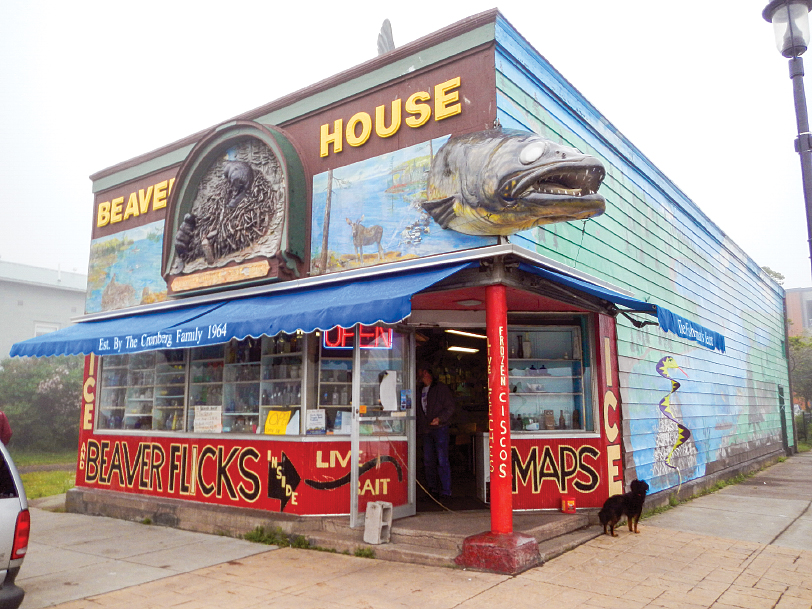
The head of a huge fiberglass walleye pokes out from one corner of the iconic Beaver House bait shop in Grand Marais, and its tail pops out the other side.
Towed like a barge but also with sails, schooner-barges evolved from wooden sailing ships on the Great Lakes in the late 1800s. Steamships towed the schooner-barges, laden with grain, ore and other commodities. As the Madeira heaved and smashed against the rocks, a brave member of the crew jumped ashore with a safety line amidst the battering waves, helping eight other men to safety. By coincidence, the tugboat Edna G rescued the stranded survivors after the storm abated.
Split Rock Lighthouse was decommissioned in 1969. Since then, the Minnesota Historical Society has maintained it as the centerpiece of Split Rock Lighthouse State Park. The lighthouse campus includes the tower, a fog-signal building with immense horns on its lakeward facade, houses and barns where the lightkeepers resided and a boathouse.
After climbing the lighthouse, we followed a path to a long concrete staircase, which sloped steeply down to the water. It descended next to the ruins of an old tramway, a rail system that was used to hoist supplies from the boathouse to the top of the cliff. Standing on the boulder-strewn beach, the lighthouse loomed above us as a stalwart landmark and a reminder of the many sailors who lost their lives to the lake in the past 150 years.
Grand Marais. The next day we continued up the coast, hoping to rent kayaks in Grand Marais for a paddle on the lake, but the day brought pea-soup fog. Lake Superior is so large that it impacts the regional weather. Like a sea, it has onshore and offshore breezes. When the wind carries warm, humid air from the land over the chilly water, it condenses, forming fog and thwarting any water-bound activities.
Instead, we visited the North House Folk School by the harbor in Grand Marais. The school offers classes in traditional arts and crafts that reflect the heritage of northern Minnesota. Anyone can sign up for classes in such time-honored skills such as bread baking, woodcarving, boatbuilding, basket weaving, blacksmithing, toolmaking and the various fiber arts. A hobbyist hideaway for those who like to work with their hands, the school offered a unique look at the region’s heritage while preserving it for future generations.
Afterward, as we headed south from Grand Marais to our campsite at Gooseberry Falls, we contemplated the school, appreciating its contribution to preserving the past. For the present, we needed to travel on. In the future, we knew we would be back. Lake Superior’s northwest shoreline is too great to limit to one visit. It’s a coastal gem loaded with delightful surprises.
Lake of Many Names
Most people believe Lake Superior is so named because it is superior in size to the other Great Lakes. That’s true, at least from the British point of view, though the lake has also been called Gitche Gumee (spelled various ways) or “the shining blue seawater,” “great water” or “great sea” by the Ojibwe (Chippewa) who inhabited the area about 500 years ago. French explorers during the 1600s and the fur trappers who followed them called it “le lac Supérieur,” which translates to “Upper Lake” — in this case, the lake above Lake Huron. Shortly after that, Jesuit missionaries in the area referred to it as “lac Tracy” after Marquis Alexandre de Prouville de Tracy, a French aristocrat who initiated the war that left the Iroquois and Mohawk nations under French rule and forced them to accept Catholicism. After the British gained control of the region following the French and Indian War, they Anglicized le lac Supérieur to Lake Superior.
Lake Superior Stats and Facts
Lake Superior is the coldest, deepest and highest in elevation of the five Great Lakes and contains 10 percent of the world’s fresh water. There is enough water in Lake Superior to submerge North and South America in 12 inches of water. Lake Superior is the western start of the 2,342-mile-long St. Lawrence Seaway, and Duluth, the westernmost point of Lake Superior, is the farthest inland of any port in the world.
It is said that this great lake “never gives up her dead” because of its low water temperature. With an average temperature of 40 degrees Fahrenheit, the water is so cold, it inhibits the growth of bacteria that causes bodies to bloat and then rise to the surface. Divers typically find victims fully preserved years afterward. During most winters, 40 to 95 percent of the lake’s surface freezes over; however, the lake freezes completely only once every 15 to 20 years.
• Surface area: 31,700 square miles
• Average depth: 489 feet
• Deepest point: 1,333 feet
• Average water temperature: 40 degrees F
• Shore length: 1,826 miles, plus 900
miles of island shoreline
• Length (at longest point): 350 miles
• Width (at widest point): 160 miles
• Number of fish species: 78
• Average underwater visibility: 24 feet
• Tallest known wave: 51 feet
• Number of shipwrecks: 350
Travel Tips and Where to Stay
Summer is prime time for vacationing on the part of the Lake Superior coastline called the North Shore, though visitors abound year-round, hunting in the fall, and ice-skating, snowshoeing, snowmobiling, and downhill and cross-country skiing in winter. The lake is calmest during June and July. October and November are the stormiest months.
Grand Marais
Grand Marais Campground and Marina
800-998-0959 | www.grandmaraisrecreationarea.com
Grand Portage
Grand Portage Marina and RV Park
218-475-2476 | www.grandportage.com/marina.php
Knife River
Knife River Campground
218-834-5044 | www.kniferivercampground.com
Two Harbors
Burlington Bay Campground (city owned)
218-834-2021 | www.bookyoursite.com/campground/harborsburling
Penmarallter Campsite
218-834-4603 | www.penmaralltercampsite.com
Minnesota State Parks
Eight state parks along Highway 61 have public campgrounds: Cascade River, George Crosby Manitou, Gooseberry Falls, Grand Portage, Judge C.R. Magney, Split Rock Lighthouse, Temperance River and Tettegouche. Reservations are highly recommended. The campgrounds fill up, especially on summer weekends.
888-646-6367 | www.dnr.state.mn.us/state_parks